Loading...

🎉 Enjoy a Free 7-Day Supporter Trial and Unlock Exclusive Perks — No Credit Card Required. Learn more.

Trimble Mountain Hike

Directions
Map
Pictures
Send to App
Distance:
4.4 Miles / 7.1 km
Type:
Loop
Difficulty:
Moderate
Time to Hike:
2 hours, ~12 minutes
Features:
Surface Type:
Dirt
Park:
George Washington National Forest
Town:
Mount Solon, Virginia
Directions:
38.362523, -79.205643
Added:
February 17, 2025
Updated:
April 05, 2025
Copy Trail Link Hiking this trail? Send a friend or family member a link to this trail guide for your own safety. Hike at your own risk (disclaimer)
Loading...
Loading...
881'

Total Change
1,191'

Ascent
1,192'

Descent

Download the Trail Route for Offline Use

Supporters get exclusive access to download trail routes to the MyHikes app for offline use. Stay prepared on your adventure, even without an internet connection! Become a Supporter today to unlock this feature and hike with confidence.

Send to App

Trimble Mountain Hike

The Trimble Mountain loop is an easy to moderate loop situated just opposite the Todd Lake Recreation Area on FDR95. There are several views of Big Bald Knob and Little Bald Knob on the western section of the loop. At the end of the circuit, the short climb up to the Todd Lake dam embankment offers a beautiful lunch spot, and view of the lake.

The Trimble Mountain Hike is just one of many hikes that are located in the Todd Lake area. A great weekend plan is to come in on a Saturday and hike Trimble Mountain, take a dip in Todd Lake, camp at the Todd Lake campground, then hike the North River Gorge circuit early Sunday before leaving.

The Todd Lake Campground has clean shower and restroom facilities, as well as a sandy beach and picnic area at the lake. The campsites are $16 per/night, and are on a first come first served basis. Reservations are not accepted. If the campsite is full, there are numerous free camping spots available along the North River off FDR95. Todd Lake Recreation Area is open from Memorial Day through Labor Day.

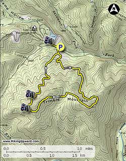
From the parking area walk up to the turnout, cross FDR95 and start up the yellow blazed Trimble Mountain Trail. In 400ft the Trimble Mountain Trail will split at a clearing. We recommend going to the left, or clockwise, as it's less steep on the ascent, and the best views are on the westerly descent of the mountain.

After turning left, the trail will gradually climb Trimble Mountain becoming steeper before arriving at the ridge in 1.2 miles. The trail will follow the ridge climbing the northern summit, before passing through a saddle and climbing over the southerly summit.

As the trail begins to descend the westerly section of Trimble Mountain, there are two good vistas of Big Bald and Little Bald Mountains to the west. The trail will then descend more steeply before arriving back at the clearing, and beginning of the loop 1.0 miles from the last vista. Stay left returning to the parking area in another 400ft.

Lake View Out/Back: After returning to the parking area make sure to continue following the yellow blazed trail up to the crest of the dam for a beautiful view of Todd Lake and lunch spot.

Explore 36 trails near Mount Solon, VA
  1. Parking

    38.362523, -79.205643
  2. Main Trailhead

    38.362287, -79.205461
No community routes found. To add your own hike as a Community Route for this Trail guide, leave a Trip Report with an attached GPX file.

Hazards

Ticks - Lyme Disease More Info (CDC)
Snakes
Poison Ivy/Oak

Seasons

All

Blaze Color

Yellow

Trip Reports

Trail Guide By:
HikingUpward user profile picture
4.4 miles / 7.1 km

Weather Forecast

In Mount Solon, VA

Explore Hiking Trails

You May Also Like

New York's Best Waterfalls - Whether you're planning a day hike, roadside stop, or a leisurely short walk, this guide provides hikers, travelers, and locals alike with 63 different locations to over 100 scenic waterfalls to help plan your next adventure!
Explore

New York's Best Waterfalls

Whether you're planning a day hike, roadside stop, or a leisurely short walk, this guide provides hikers, travelers, and locals alike with 63 different locations to over 100 scenic waterfalls to help plan your next adventure!

Read
25 Best Day Hikes in North Carolina - Discover the top 25 best day hikes in North Carolina, from breathtaking waterfalls to mountain peaks. Explore hidden gems, scenic views, and trails suitable for all skill levels, perfect for your next outdoor adventure.
Explore

25 Best Day Hikes in North Carolina

Discover the top 25 best day hikes in North Carolina, from breathtaking waterfalls to mountain peaks. Explore hidden gems, scenic views, and trails suitable for all skill levels, perfect for your next outdoor adventure.

Read

Before you boogie...

Find our trail guides useful? Consider becoming a Supporter to unlock perks!

MyHikes is an indie platform that makes exploring public trails easier for everyone. The platform has no investors, no ads, and is owned and operated by one person, Dave Miller. Dave has personally mapped and written over 1,800 trail guides on MyHikes for the public to explore. MyHikes has helped millions outdoor enthusiasts plan their next adventure.

But it takes a lot of time 🕦, money 💰, work, and espresso shots ☕ to run MyHikes, including hiking , mapping , writing , and publishing new trails with high-quality (accurate) information... along with software engineering (coding) the platform like building new features, website and mobile app development (iOS and Android), site maintainance . and much much more.

Supporters unlock website and mobile app perks with an annual one-time payment of $25 (you renew) 😎👍. Or you can simply make a Donation of your choice. Otherwise, you can support us by telling your friends about MyHikes - both quick and free 🎉

Admin user profile picture

Dave Miller
MyHikes Founder