Loading...

🎉 Enjoy a Free 7-Day Supporter Trial and Unlock Exclusive Perks — No Credit Card Required. Learn more.

Torry Ridge and White Rock Falls Hike

Directions
Map
Pictures
Send to App
Distance:
9.4 Miles / 15.1 km
Type:
Loop
Difficulty:
Hard
Time to Hike:
4 hours, ~42 minutes
Features:
Surface Type:
Dirt
Park:
George Washington National Forest
Town:
Vesuvius, Virginia
Directions:
37.896258, -79.045367
Added:
February 17, 2025
Updated:
April 05, 2025
Copy Trail Link Hiking this trail? Send a friend or family member a link to this trail guide for your own safety. Hike at your own risk (disclaimer)
Loading...
Loading...
1,110'

Total Change
1,855'

Ascent
1,852'

Descent

Download the Trail Route for Offline Use

Supporters get exclusive access to download trail routes to the MyHikes app for offline use. Stay prepared on your adventure, even without an internet connection! Become a Supporter today to unlock this feature and hike with confidence.

Send to App

Torry Ridge and White Rock Falls Hike

The Torry Ridge hike, just south of Waynesboro VA, passes through one of the premier campgrounds in the GWNF, Sherando Lake. With both camper and tent camping as well as a fantastic lake with a man made beach, this hike plus other trails in the area such as St Mary's Wilderness, this makes for a great weekend getaway spot.

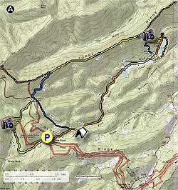
This circuit has three possible start points. Sherando Lake, The Slacks Overlook, or how we have it mapped here, from White Rock Gap. Cross the Blue Ridge Parkway (BRP) and start south down the yellow blazed White Rock Falls trail. In 1.2 miles cross White Rock Creek then start the steepest section of the hike as the trail makes several switchbacks. In 0.2 miles after crossing the creek, look for a faint unmarked trail that leads down to a 30ft waterfall.

Continue up the yellow blazed trail and 0.3 miles from the waterfall are two vistas of the White Rock Creek gorge. From this point the trail will become less steep and arrive at the BRP in another 0.4 miles. Cross the BRP and follow the unmarked connector trail behind the picnic table for 100 yards to the intersection of the Slacks trail.

Turn left on the blue blazed Slacks trail and follow it 0.9 miles to the intersection of the Torry Ridge trail. Turn right on the yellow blazed Torry Ridge trail and follow it 2.0 miles to the intersection off the blue blazed trail that leads down to Sherando lake. the Torry Ridge Trail has several nice views of Bald Mountain and Kelly Mountain.

Turn right down the blue blazed trail and arrive at the Sherando Lake overlook in 0.2 miles. Continue down the trail for another 0.1 miles to the Dam trail intersection. Stay left on the Dam trail for 0.3 miles where it ends at the orange blazed Lake trail and Sherando Lake. Turn right following the orange blazed trail around the lake to where the orange trail ends at the picnic area.

For the next 0.9 miles follow the campground roads to the south end of the recreation area and upper dam. Climb to the crest of the dam, then turn right and follow it all the way to the right side. Do Not go down the steps on the water side of the dam.

At the end of the dam turn left on the orange blazed White Rock Gap trail and in 1.8 miles pass the one good campsite on the circuit. From the campsite it is another 0.3 miles to the intersection of the blue blazed Slacks Trail.

Stay straight on the orange blazed trail for the remaining 0.4 miles back to the BRP, and White Rock Gap parking area.

Explore 35 trails near Vesuvius, VA
  1. Parking

    37.896258, -79.045367
  2. Main Trailhead

    37.896139, -79.045644
No community routes found. To add your own hike as a Community Route for this Trail guide, leave a Trip Report with an attached GPX file.

Hazards

Ticks - Lyme Disease More Info (CDC)
Snakes
Poison Ivy/Oak

Seasons

All

Trip Reports

Trail Guide By:
HikingUpward user profile picture
9.4 miles / 15.1 km

Weather Forecast

In Vesuvius, VA

Explore Hiking Trails

You May Also Like

New York's Best Waterfalls - Whether you're planning a day hike, roadside stop, or a leisurely short walk, this guide provides hikers, travelers, and locals alike with 63 different locations to over 100 scenic waterfalls to help plan your next adventure!
Explore

New York's Best Waterfalls

Whether you're planning a day hike, roadside stop, or a leisurely short walk, this guide provides hikers, travelers, and locals alike with 63 different locations to over 100 scenic waterfalls to help plan your next adventure!

Read
25 Best Day Hikes in North Carolina - Discover the top 25 best day hikes in North Carolina, from breathtaking waterfalls to mountain peaks. Explore hidden gems, scenic views, and trails suitable for all skill levels, perfect for your next outdoor adventure.
Explore

25 Best Day Hikes in North Carolina

Discover the top 25 best day hikes in North Carolina, from breathtaking waterfalls to mountain peaks. Explore hidden gems, scenic views, and trails suitable for all skill levels, perfect for your next outdoor adventure.

Read

Before you boogie...

Find our trail guides useful? Consider becoming a Supporter to unlock perks!

MyHikes is an indie platform that makes exploring public trails easier for everyone. The platform has no investors, no ads, and is owned and operated by one person, Dave Miller. Dave has personally mapped and written over 1,800 trail guides on MyHikes for the public to explore. MyHikes has helped millions outdoor enthusiasts plan their next adventure.

But it takes a lot of time 🕦, money 💰, work, and espresso shots ☕ to run MyHikes, including hiking , mapping , writing , and publishing new trails with high-quality (accurate) information... along with software engineering (coding) the platform like building new features, website and mobile app development (iOS and Android), site maintainance . and much much more.

Supporters unlock website and mobile app perks with an annual one-time payment of $25 (you renew) 😎👍. Or you can simply make a Donation of your choice. Otherwise, you can support us by telling your friends about MyHikes - both quick and free 🎉

Admin user profile picture

Dave Miller
MyHikes Founder