The Timber Creek Overlook Trail at Zion National Park in New Harmony, Utah is an easy 1.2-mile out-and-back trail that leads to one of the best lookout points in the park.
Temporarily Closed
Note that as of September 2023, this section of Zion National Park is closed due to necessary road repairs after recent landslides. The road is not slated to be open to the public until sometime in 2024.
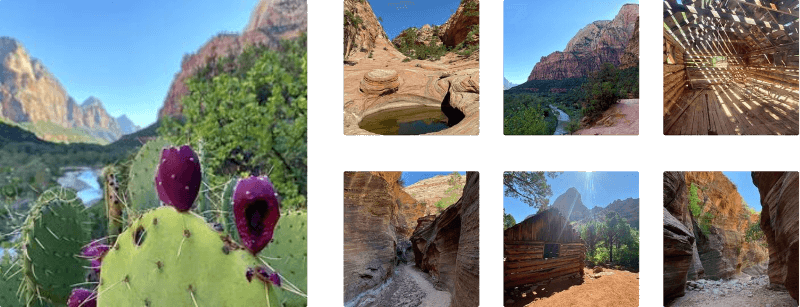
This little trail is one of the best trails in Zion, also it is the easiest trail in Zion. The scenery from the top is magnificent and you can see for miles across the canyon. Once you reach the top of the climb, you might gasp as you look out across the vast beauty that awaits your arrival at the overlook for such an easy hike.
Permits: You must purchase a wilderness permit at the Kolob Canyon Visitor Center before accessing the park.
Directions: The Overlook trail is the third and finial trail on the Kolob Canyon Road. You will find plenty of parking and facilities at the trail-head.
Warning: Bring plenty of water to stay hydrated.
Pets: Dogs are not allowed in the wilderness section of Zion. Please see the park site link for more details about where dogs are allowed.
Tips: Don't forget your camera - you'll be stopping often to take photos in an effort to capture this wonder.
Temporarily Closed
Note that as of September 2023, this section of Zion National Park is closed due to necessary road repairs after recent landslides. The road is not slated to be open to the public until sometime in 2024.
This little trail is one of the best trails in Zion, also it is the easiest trail in Zion. The scenery from the top is magnificent and you can see for miles across the canyon. Once you reach the top of the climb, you might gasp as you look out across the vast beauty that awaits your arrival at the overlook for such an easy hike.
Permits: You must purchase a wilderness permit at the Kolob Canyon Visitor Center before accessing the park.
Directions: The Overlook trail is the third and finial trail on the Kolob Canyon Road. You will find plenty of parking and facilities at the trail-head.
Warning: Bring plenty of water to stay hydrated.
Pets: Dogs are not allowed in the wilderness section of Zion. Please see the park site link for more details about where dogs are allowed.
Tips: Don't forget your camera - you'll be stopping often to take photos in an effort to capture this wonder.