Loading...

🔥 End of Summer sale! 50% off on Supporter Accounts — now through September 1st. Learn More.

Tibbet Knob Hike

Directions
Map
Pictures
Send to App
Distance:
3.2 Miles / 5.1 km
Type:
Out-and-Back
Difficulty:
Hard
Time to Hike:
1 hour, ~36 minutes
Features:
Surface Type:
Dirt
Park:
George Washington National Forest
Town:
Edinburg, Virginia
Directions:
38.923483, -78.689517
Added:
February 17, 2025
Updated:
April 05, 2025
Guide by:
Copy Trail Link Hiking this trail? Send a friend or family member a link to this trail guide for your own safety. Hike at your own risk (disclaimer)
Loading...
Loading...
687'

Total Change
1,087'

Ascent
1,086'

Descent

Download the Trail Route for Offline Use

Supporters get exclusive access to download trail routes to the MyHikes app for offline use. Stay prepared on your adventure, even without an internet connection! Become a Supporter today to unlock this feature and hike with confidence.

Send to App

Tibbet Knob Hike

Tibbet Knob is the sister hike to Big Schloss. Starting from the same parking location at the Wolf Gap Campground the hike heads in the opposite direction along the Tibbet Knob Trail. Although shorter, this hike is not as family friendly because of two short, steep scrambles to the main Tibbet Knob summit.

Big Schloss is one of the most well known, and most panoramic hikes in the region, with an almost 270° vista from the main overlook. Tibbet Knob is nearly identical in distance to the Big Schloss hike, and is every bit as spectacular. Boasting a wider and more spectacular panorama to the north and west, a wonderful vista just below the high point to the east, and probably the most perfectly placed campsite in the whole Great North Mountain area!

Where the Big Schloss hike can draw many people on nicer days, the Tibbet Knob hike generally has a fraction the number of hikers. For vista after vista, without the crowds, this hike is hard to beat.

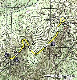
From the parking area cross VA675 and start up the yellow blazed Tibbet Knob Trail. In 0.5 miles cross over a small summit that provides great views of Big Schloss and Mill Mountain to the northeast.

After crossing the small summit the trail descends, then veers right between the ridges, before turning back to the left steeply uphill. In 0.4 miles from starting up the main ridge, climb the first of two steep sections that may require hand over hand climbing. Both are only 20-30 yards in length.

At the top of the first steep section the trail passes through a flat area before you reach the second steep area. After reaching the top of this scramble follow the trail for the remaining 200 yards to the top of Tibbet Knob, and pass through a thicket to one of the most spectacular overlooks in the whole region. Twenty feet past the overlook there is a great campsite that could accommodate two small tents.

To return just follow the trail back to the Wolf Gap Campground.

Note: To incorporate this out and back hike into a more strenuous 13.3 mile shuttle hike see MidAtlanticHikes.com Long Mountain/Tibbet Knob Shuttle Hike.
Explore 79 trails near Edinburg, VA
  1. Parking

    38.923483, -78.689517
  2. Main Trailhead

    38.923693, -78.689661
No community routes found. To add your own hike as a Community Route for this Trail guide, leave a Trip Report with an attached GPX file.

Hazards

Ticks - Lyme Disease More Info (CDC)
Snakes
Poison Ivy/Oak

Seasons

All

Blaze Color

Yellow

Trip Reports (Reviews)

Rated 4.17 out of 5 based on 76 ratings.
By: Yoda
3.2 miles / 5.1 km
November 17, 2019
Great hike. A little steeper then I remember. The GPS seems to miss the last turn up Wolf Gap rd for some reason. Look for the Wolf Gap sign. Watch out for black ice on the roads near Wolf Gap. Those mountain roads get cold and are in the shade. Trail was fogged out the entire time and a snow dusting on the trail. I thought this hike was a little more difficult than Big Schloss because the trail continually goes up and down. I didn't remember the path being so hilly. Wondering if the route got changed a little. On the way back to the parking lot a couple asked us if we lost an axe they found on the trail. Not ours but it belonged to two backpackers who passed us on the way up. The Lee Ranger station has info on how to get the axe back. We believe the axe belongs to some backpackers with a black SUV.
Legacy Review
By: Karen
3.2 miles / 5.1 km
August 31, 2019
Enjoyed this hike. Started early so we didn’t have any parking problems. The view was beautiful at the top and not crowded going up or coming down. The trail was rocky enough I’m glad I had my hiking poles for better footing. The two scrambles across the larger rocks at the top were not bad since there was no waiting, but good to know they were there to have to climb over and then back down. Just before the first rock scramble, off through some brush to the right, is a cave opening. At the top, off to the left, someone had gathered some nice size rocks to make a fire pit and there were two primitive flat areas where tents had recently been set. We saw a beautiful deer near the overlook toward the east when we were coming back down and a yellow ringneck snake on the way up. No squirrels or other wildlife although there were lots of nuts in various places on the trail.
Legacy Review
By: Chris
3.2 miles / 5.1 km
March 18, 2018
This is a nice little warm-up jaunt prior to hiking Big Schloss. Based on the description from this excellent website (which I support with an annual donation because it's so fantastic) I was planning to just hike Tibbet Knob, but honestly...it was a little disappointing. After knocking it out in 1.5 hours total (including sitting at the top for about 20 minutes) I decided to do Big Schloss as well. I'm going to have to disagree with the above description and state that the views were much, much better on Big Schloss, not just at the end but also all the views along the trail, much of which is ridgeline hiking. Fewer hikers on Tibbet Knob, sure--but if you time it so you arrive at the "top" about an hour before sunset, you'll maybe have the top to yourself like I did.
Legacy Review

Weather Forecast

In Edinburg, VA

Explore Hiking Trails

You May Also Like

New York's Best Waterfalls - Whether you're planning a day hike, roadside stop, or a leisurely short walk, this guide provides hikers, travelers, and locals alike with 63 different locations to over 100 scenic waterfalls to help plan your next adventure!
Explore

New York's Best Waterfalls

Whether you're planning a day hike, roadside stop, or a leisurely short walk, this guide provides hikers, travelers, and locals alike with 63 different locations to over 100 scenic waterfalls to help plan your next adventure!

Read
25 Best Day Hikes in North Carolina - Discover the top 25 best day hikes in North Carolina, from breathtaking waterfalls to mountain peaks. Explore hidden gems, scenic views, and trails suitable for all skill levels, perfect for your next outdoor adventure.
Explore

25 Best Day Hikes in North Carolina

Discover the top 25 best day hikes in North Carolina, from breathtaking waterfalls to mountain peaks. Explore hidden gems, scenic views, and trails suitable for all skill levels, perfect for your next outdoor adventure.

Read

Before you boogie...

Find our trail guides useful? Consider becoming a Supporter to unlock perks!

MyHikes is an indie platform that makes exploring public trails easier for everyone. The platform has no investors, no ads, and is owned and operated by one person, Dave Miller. Dave has personally mapped and written over 1,800 trail guides on MyHikes for the public to explore. MyHikes has helped millions outdoor enthusiasts plan their next adventure.

But it takes a lot of time 🕦, money 💰, work, and espresso shots ☕ to run MyHikes, including hiking , mapping , writing , and publishing new trails with high-quality (accurate) information... along with software engineering (coding) the platform like building new features, website and mobile app development (iOS and Android), site maintainance . and much much more.

Supporters unlock website and mobile app perks with an annual one-time payment of $25 (you renew) 😎👍. Or you can simply make a Donation of your choice. Otherwise, you can support us by telling your friends about MyHikes - both quick and free 🎉

Admin user profile picture

Dave Miller
MyHikes Founder