The Three Falls Trail at Three Falls Public Open Space in Alpine, Utah is a moderate 0.9-mile out-and-back hike that explores several creeks and waterfalls within Lower Fort Creek and Fortknocker Creek.
Hike
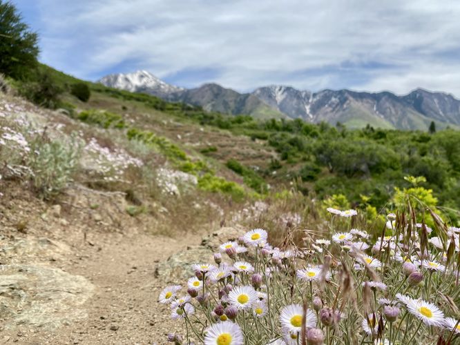
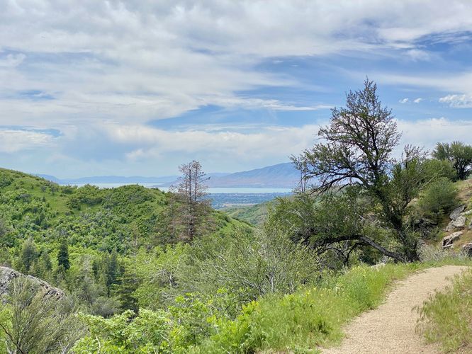
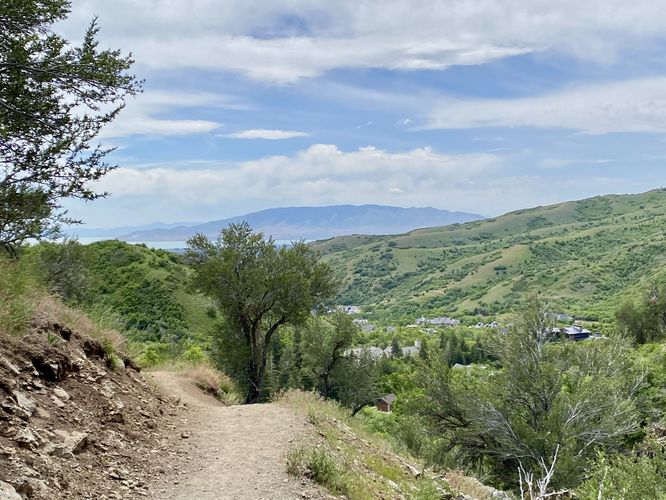
This hike begins along the north side of North Three Falls Drive in Alpine, Utah and follows the dirt path as it leads up the southern foothills of Enniss Peak. This hike first heads down the Forbidden Trail to explore the creek to the east. During my hike here in late May 2024, I found the eastern creek to be totally dry (dry run?) with no sights of ledges or cliffs for waterfalls. If you choose to follow the Forbidden Trail, you'll find beautiful mountain views along the way. During Spring and Summer, you'll also find plenty of wildflowers on the Forbidden Trail.
Three Falls Trail to Waterfalls - Mile 0.45 to 0.8
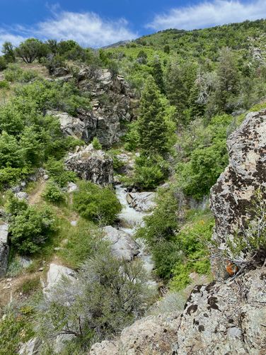
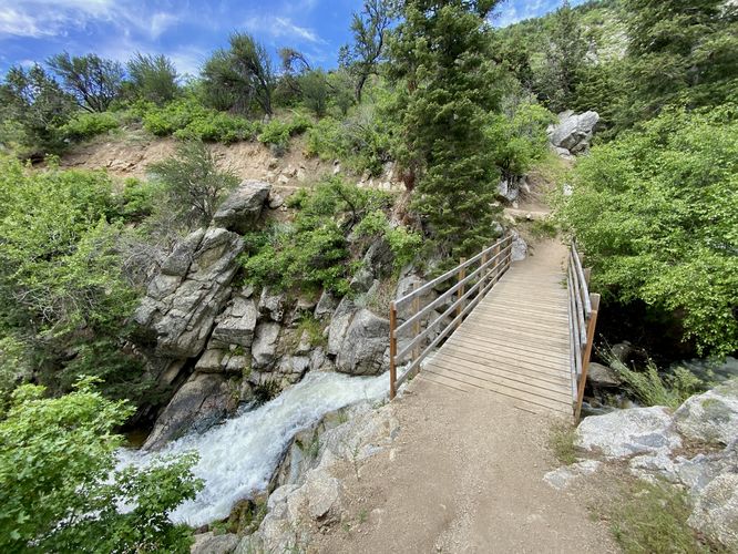
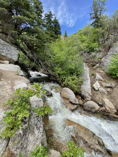
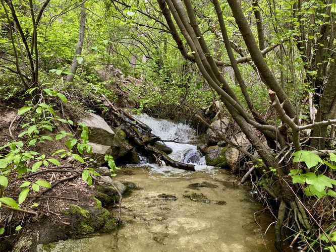
After exploring the optional Forbidden Trail, this route takes hikers to view five different waterfalls, despite the trail's name. It leads up a fairly-steep hill to where it reaches a footbridge. Just below the footbridge is a ~15-foot waterfall around mile 0.5 in this GPS route. Just up the creek, on the right-hand side, is a ~4 or 5-foot waterfall that I didn't photograph due to swimmers. Upstream from that is another series of cascades that you can check out before the trail follows a bend in the hillside. If you hike further along this route, the track ends at Fortknocker Creek where you'll find very small cascades. There's a nice ~4-foot tall waterfall that spills down this creek located just south of where the track ends, around mile 0.6. Follow the trail back downhill and if you want, you can explore the sketchy and dangerous off-trail hike to reach a view of the Lower Fort Creek falls around mile 0.8. You must be extremely careful as the best view of this waterfall sits along a sloped incline with a steep cliff drop-off near the end -- the incline also includes loose rocks.
After exploring the waterfalls along the Three Falls Trail, the hike leads back to parking for a 0.9-mile out-and-back hike.
Parking
Hikers will find street parking near the coordinates provided on North Three Falls Drive in Alpine, Utah. There's enough room for less than 10 vehicles that can line the south side of the road. This is a busy road, so watch on-coming traffic.
Pets
Dogs are allowed only if leashed and must be cleaned up after.
Warning
Steep cliffs: This trail follows steep cliffs, especially near the creek's gorge. Hike at your own risk if you choose to head off-trail to view waterfalls.
Hike
This hike begins along the north side of North Three Falls Drive in Alpine, Utah and follows the dirt path as it leads up the southern foothills of Enniss Peak. This hike first heads down the Forbidden Trail to explore the creek to the east. During my hike here in late May 2024, I found the eastern creek to be totally dry (dry run?) with no sights of ledges or cliffs for waterfalls. If you choose to follow the Forbidden Trail, you'll find beautiful mountain views along the way. During Spring and Summer, you'll also find plenty of wildflowers on the Forbidden Trail.
Three Falls Trail to Waterfalls - Mile 0.45 to 0.8
After exploring the optional Forbidden Trail, this route takes hikers to view five different waterfalls, despite the trail's name. It leads up a fairly-steep hill to where it reaches a footbridge. Just below the footbridge is a ~15-foot waterfall around mile 0.5 in this GPS route. Just up the creek, on the right-hand side, is a ~4 or 5-foot waterfall that I didn't photograph due to swimmers. Upstream from that is another series of cascades that you can check out before the trail follows a bend in the hillside. If you hike further along this route, the track ends at Fortknocker Creek where you'll find very small cascades. There's a nice ~4-foot tall waterfall that spills down this creek located just south of where the track ends, around mile 0.6. Follow the trail back downhill and if you want, you can explore the sketchy and dangerous off-trail hike to reach a view of the Lower Fort Creek falls around mile 0.8. You must be extremely careful as the best view of this waterfall sits along a sloped incline with a steep cliff drop-off near the end -- the incline also includes loose rocks.
After exploring the waterfalls along the Three Falls Trail, the hike leads back to parking for a 0.9-mile out-and-back hike.
Parking
Hikers will find street parking near the coordinates provided on North Three Falls Drive in Alpine, Utah. There's enough room for less than 10 vehicles that can line the south side of the road. This is a busy road, so watch on-coming traffic.
Pets
Dogs are allowed only if leashed and must be cleaned up after.
Warning
Steep cliffs: This trail follows steep cliffs, especially near the creek's gorge. Hike at your own risk if you choose to head off-trail to view waterfalls.