Loading...

๐ŸŽ† 50% off 4th of July sale on Supporter Accounts โ€” now through July 6! Learn More.

Thornton Thruway Trail

Directions
Map
Pictures
Send to App
Distance:
0.5 Miles / 0.8 km
Type:
One-Way
Difficulty:
Moderate
Time to Hike:
~15 minutes
Features:
Surface Type:
Dirt
Park:
Pfeiffer Nature Center - Lillibridge Property
Town:
Portville, New York
Directions:
42.09415, -78.327642
Added:
October 31, 2019
Updated:
October 31, 2019
Copy Trail Link Hiking this trail? Send a friend or family member a link to this trail guide for your own safety. Hike at your own risk (disclaimer)
Loading...
Loading...
302'

Total Change
5'

Ascent
302'

Descent

Download the Trail Route for Offline Use

Supporters get exclusive access to download trail routes to the MyHikes app for offline use. Stay prepared on your adventure, even without an internet connection! Become a Supporter today to unlock this feature and hike with confidence.

Send to App

Thornton Thruway Trail

The Thornton Thruway Trail at Pfeiffer Nature Center's Lillibridge Property in Portville, New York is an easy to moderate 0.5-mile one-way trail that features a beautiful woodland hike through the park.

This trail, when hiked east to west is easy as it makes its way gradually downhill. The trail, however, is moderate when hiked west to east as the trail ascends the neighboring hill. The difficulty listed here is moderate for that reason.

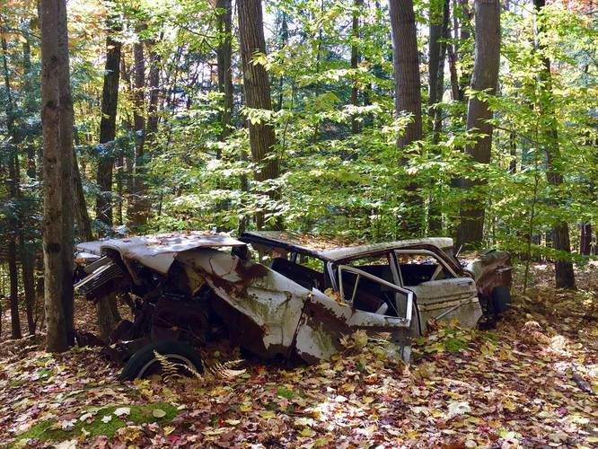
The Thornton Thruway connects to three trails including the Hog's Back Trail, Emery Trail, and Warner's Way. This recording begins at the eastern terminus (junction with the Hog's Back) and ends at the Emery Trail to the west. Along the trail, just a stones-throw distance off of the actual path, is an old rusty car wasting away in the woods. This is a neat feature that hikers can stop at; however, it's difficult to tell if this old car is on private property or on the Lillibridge Property - hence why there is no spur trail on the map that leads to the car itself.

Parking
Hikers can find parking at the coordinates provided. The parking lot is large enough to fit about 8 large vehicles.

Pets
Dogs are allowed if leashed and their waste must be carried out by the hiker.

Blaze Color
This trail follows white blazes much like the rest of the trails at the Lillibridge Property, which can be confusing.
Explore 11 trails near Portville, NY
  1. Parking

    42.09415, -78.327642
  2. Main Trailhead

    42.089021, -78.319032
  3. Rusty old car off of the trail

    42.088806, -78.323411
    Rusty old car off of the trail
No community routes found. To add your own hike as a Community Route for this Trail guide, leave a Trip Report with an attached GPX file.

Hazards

Ticks - Lyme Disease More Info (CDC)

Seasons

All

Weather Forecast

In Portville, NY

Explore Hiking Trails

You May Also Like

Colorado's Million Dollar Highway - Plan a day's drive adventure along the iconic Million Dollar Highway in Colorado. Explore the best short trails, roadside stops, waterfalls, vistas, ghost towns, and hot springs within a ~6 hour road trip.
Explore

Colorado's Million Dollar Highway

Plan a day's drive adventure along the iconic Million Dollar Highway in Colorado. Explore the best short trails, roadside stops, waterfalls, vistas, ghost towns, and hot springs within a ~6 hour road trip.

Read
Glacier's Going-to-the-Sun Road - Discover the breathtaking beauty of Glacier National Park along the iconic Going-to-the-Sun Road. From stunning roadside stops to picturesque waterfalls and vistas, this engineering marvel offers endless opportunities for exploration.
Explore

Glacier's Going-to-the-Sun Road

Discover the breathtaking beauty of Glacier National Park along the iconic Going-to-the-Sun Road. From stunning roadside stops to picturesque waterfalls and vistas, this engineering marvel offers endless opportunities for exploration.

Read
New York's Best Waterfalls - Whether you're planning a day hike, roadside stop, or a leisurely short walk, this guide provides hikers, travelers, and locals alike with 63 different locations to over 100 scenic waterfalls to help plan your next adventure!
Explore

New York's Best Waterfalls

Whether you're planning a day hike, roadside stop, or a leisurely short walk, this guide provides hikers, travelers, and locals alike with 63 different locations to over 100 scenic waterfalls to help plan your next adventure!

Read

Before you boogie...

Find our trail guides useful? Consider becoming a Supporter to unlock perks!

MyHikes is an indie platform that makes exploring public trails easier for everyone. The platform has no investors, no ads, and is owned and operated by one person, Dave Miller. Dave has personally mapped and written over 1,800 trail guides on MyHikes for the public to explore. MyHikes has helped millions outdoor enthusiasts plan their next adventure.

But it takes a lot of time ๐Ÿ•ฆ, money ๐Ÿ’ฐ, work, and espresso shots โ˜• to run MyHikes, including hiking , mapping , writing , and publishing new trails with high-quality (accurate) information... along with software engineering (coding) the platform like building new features, website and mobile app development (iOS and Android), site maintainance . and much much more.

Supporters unlock website and mobile app perks with an annual one-time payment of $25 (you renew) ๐Ÿ˜Ž๐Ÿ‘. Or you can simply make a Donation of your choice. Otherwise, you can support us by telling your friends about MyHikes - both quick and free ๐ŸŽ‰

Admin user profile picture

Dave Miller
MyHikes Founder