Loading...

WINTER SALE! 50% OFF Supporter Accounts — now through January 31st. Learn More.

Thornton River Hike

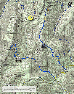
This hike winds along scenic Thornton River, one of the Shenandoah National Park's North District's prime attractions, passing remnants of old homesteads left over from before the Park's creation. There are also small pools on Thornton River, and a nice vista on Piney Ridge. The trail starts and ends at Elkwallow Wayside on Skyline Drive, making it easy to pick up supplies or some cool refreshments at the end of a summer’s day hike.

  • Mile 0.0 - From the eastern end of the Elkwallow Wayside parking area, cross Skyline Drive to join the white-blazed Appalachian Trail (AT).
  • Mile 0.9 - The AT comes to a four-way intersection with the Range View Fire Road. Turn right onto the Range View Fire Road and in 150 feet take a second right onto the blue-blazed Piney Ridge Trail.
  • Mile 2.8 - Piney Ridge Trail descends along the ridgeline to an intersection with Fork Mountain Trail. Keep right onto Fork Mountain Trail and continue to descend along the ridge.
  • Mile 4.0 - Fork Mountain Trail passes through a grove of redbuds before ended at a T-intersection with the yellow-blazed Thornton Hollow Trail at the foot of Fork Mountain. Turn rightand take Thornton Hollow Trail down into the valley below.
  • Mile 4.6 - In 0.6 miles the Thornton Hollow Trail meets Thornton River Trail and Hull School Trail at a four-way intersection. Turn right onto Thornton River Trail as it begins to climb back up the valley. There are several crossing points of Thornton River over the next 0.5 miles - after heavy rains or snowmelt these crossings may require getting your feet wet. Many small streams and tributaries run alongside the trail. Scattered flowering crabapple trees can be found along the valley, which are often a sign of old settler homesteads.
  • Mile 5.0 - The trail passes a series of intact stone walls left over from before the SNP that once marked farm fields.
  • Mile 6.4 - Another relic from before the Park - a rusted and overgrown car chassis sits beside the trail as a reminder of the valley’s previous inhabitants.
  • Mile 7.4 - Thornton River Trail ends at a parking lot on Skyline Drive. Continue straight ~100 yards along Skyline Drive and cross to an AT connector trail. Follow the connector trail uphill to reach the AT.
  • Mile 7.7 - The connector trail ends at the AT. Turn right onto the AT to head north towards Elkwallow Wayside.
  • Mile 9.8 - After a sharp bend the AT intersects with Jeremy’s Run Trail on the left. Keep right and continue following the AT.
  • Mile 10.0 - Keep left and pass by a side trail that goes to the Elkwallow picnic area on the right.
  • Mile 10.2 - Keep right at a split in the trail to take a short connector trail back to the Elkwallow Wayside parking lot.
  • Mile 10.3 - Return to the trail start at Elkwallow Wayside.
By HikingUpward Contributor: Michael Gergely
Explore 100 trails near Rileyville, VA

Know Before You Go

  • The Thornton River Hike is a 10.3-mile loop in Shenandoah National Park that starts and ends at Elkwallow Wayside, offering convenient access to supplies and refreshments.
  • The trail follows a diverse route along the Thornton River, up Piney Ridge, and features remnants of old homesteads and a vista point.
  • The hike involves multiple water crossings on the Thornton River, potentially requiring wet feet after heavy rain, and includes sections on the Appalachian Trail and other marked trails.
Interactive topographic map for Thornton River Hike located in Rileyville, VA. Click the "View Map" button to load GPS coordinates and trail markers.
Get directions
Distance
10.3 mi
Difficulty
Moderate
Type
Loop
Est. Time
5.2 hrs
Elev. Gain
2,270'
Rating
3.4
Added
March 19, 2025
Updated
April 06, 2025

Weather Forecast

Loading...
Total Change
1,654'
Ascent
2,270'
Descent
2,270'
Loading...

Download the GPX Data for Offline Use

Supporters get exclusive access to download trail routes to the MyHikes app for offline use. Stay prepared on your adventure, even without an internet connection! Become a Supporter today to unlock this feature and hike with confidence.

Download Thornton River Hike GPX Data to the MyHikes Mobile App

Features

Vista / Lookout Point
Dogs
Camping
Water Source
Appalachian Trail logo Appalachian Trail hike

Points of interest

  1. Parking

    38.73858, -78.309499
  2. Main Trailhead

    38.73858, -78.309499

Safety information

For your own safety: plan ahead, let someone know where you'll be, and hike at your own risk.

Hazards

Snakes (Rattlesnakes, Copperheads, others)
Poison Ivy or Poison Oak

Availability

All seasons

Surface type

Dirt

Trip Reports (Reviews)

Rated 3.4 out of 5 based on 5 ratings.

Ready to help fellow hikers? Add a trip report to share your experience and provide valuable insights for other hikers!

By: Jamey
10.3 miles / 16.6 km
April 28, 2018
I did an eight-mile variation. I parked at the Hull School Trail lot on Skyline Drive, headed up the AT, down the Thornton River Trail, and up Hull School. The AT section was pretty, and the Thornton River Trail is very easy. Except for the first one, the river crossings were tricky with high, fast water covering most of the stepping stones by a couple inches. Careful steps, poles, and good, waterproof boots kept me dry. At the post at end of the Thornton River Trail, it's a sharp right onto the Hull School Trail to ascend back to Skyline Drive. I took the second, more obvious right and went a ways in the wrong direction on Hull School before realizing my mistake. I crossed paths with two hiking parties that had also taken a wrong turn at the post, although they had meant to head up Thornton River. After getting back to the correct turn, which was narrow and flooded and thus easy to miss, I had a tough river crossing, because several large trees had fallen and crisscrossed the river. Going up the Hull School Trail, there were several more windfalls to go over, under, and around.
Legacy Review
By: Hatchet
10.3 miles / 16.6 km
March 10, 2018
Very nice conditioning hike, not rocky, good trail tread, runs along the Thornton River which is nice. There are a couple of river crossings but nothing hard. I went counter-clockwise from the Elkwallow Picnic Area and my GPS logged it at 11 miles. Water is good (for filtering). Near the end is a long, steady, not too steep climb great for a cardio/endurance workout. Parking is great with a bathroom. As of 10 March 2018 there was some significant blow-down from the great Northern Virginia windstorm of 2018, we cleared as much as we could during the hike. The trail is definitely passable, but some big trees came down taking out other big trees. It was a sight for sure. I'll be doing this hike again.
Legacy Review
By: Hobo Hiker
10.3 miles / 16.6 km
January 16, 2017
The highlight of this hike is Thorton river and the rippling mountain water sounds. I hiked this on a cold 30 degree morning with an overcast. Skyline had a recent snow so it had just been re-opened. I started at 7:30am and the parking lot was completely empty. In January the Elkwallow Wayside store and food deli is closed. It's possible the bathrooms located at the trailhead are also closed. I didn't try the bathrooms. I had a small problem finding the trailhead to start. The trailhead is located towards the northern entrance of the parking lot near the front corner of lot(maybe three spaces from the road) but no real sign. The leaves were off the trees but I never found a clear view of any good valley vistas. The first parts starts out in a pine grove so it was nice to smell some pine. I didn't see any bears, just some deer. It rained/snowed two days before so Thorton river had some nice mini waterfalls and the sound of water could be heard long before seeing the actual river/stream. You do have to cross the river with no bridges. Parts of the river are 12 feet wide with no real way to cross. You have to wander up or down the river looking for a good set of rocks to cross on or just go for it and get your feet wet. The rocks are very slick so be careful. The climb up and over to the AT trail was a little steeper than I expected from the elevation profile. Nothing that needs the use of hands or rock scrambling but for some reason seemed more challenging than I expected. I gave it 4 stars for the river.
Legacy Review
No community routes found. To add your own hike as a Community Route for this Trail guide, leave a Trip Report with an attached GPX file.

Popular categories

Scenic mountain view representing vista trails
Vista trails
Scenic gorge of cascades representing waterfall trails
Waterfall hikes
Rugged mountain terrain representing summit trails
Summit trails
Scenic mountain view representing dog-friendly trails
Dog-friendly
Scenic campsite with a view representing camping trails
Camping trails
Appalachian Trail logo representing A.T. hikes
A.T. hikes

You May Also Like

25 Best Day Hikes in North Carolina - Discover the top 25 best day hikes in North Carolina, from breathtaking waterfalls to mountain peaks. Explore hidden gems, scenic views, and trails suitable for all skill levels, perfect for your next outdoor adventure.
Explore

25 Best Day Hikes in North Carolina

Discover the top 25 best day hikes in North Carolina, from breathtaking waterfalls to mountain peaks. Explore hidden gems, scenic views, and trails suitable for all skill levels, perfect for your next outdoor adventure.

Read
🍪 We use cookies to learn about site usage and to serve map tiles. You may block cookies manually in the browser. By continuing you agree. Learn more