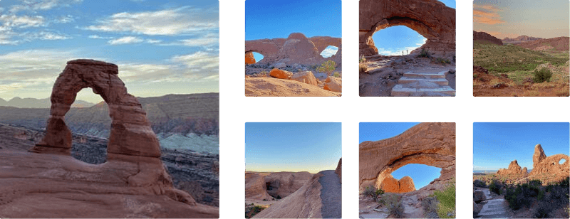
The Windows Trail at Arches National Park near Moab, Utah is an easy 1.2-mile loop hike that features three named arches -- North Window, South Window, and the Turret Arch.
Hike Description
This hike begins at the main (southern-most) trailhead and follows the trail as it heads eastward to reach the North Window Arch. Along the way, hikers will get immediate views of the Windows straight ahead in addition to the Turret Arch as it makes its appearance to the south as you approach the North Window Arch.
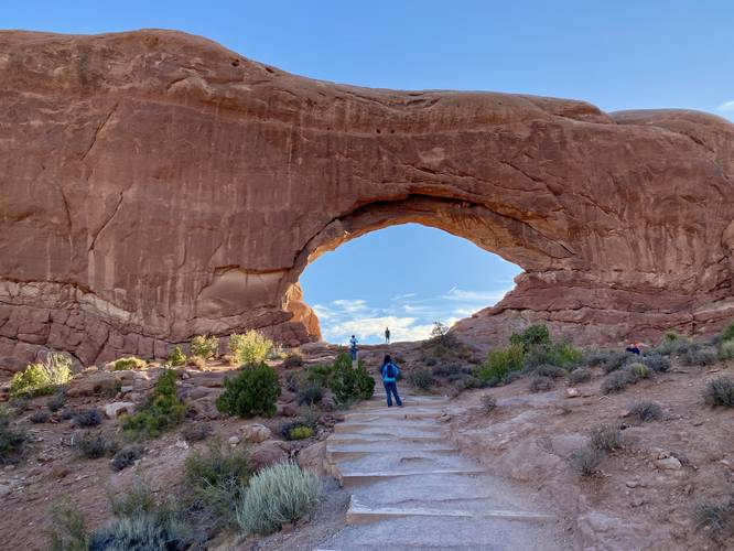
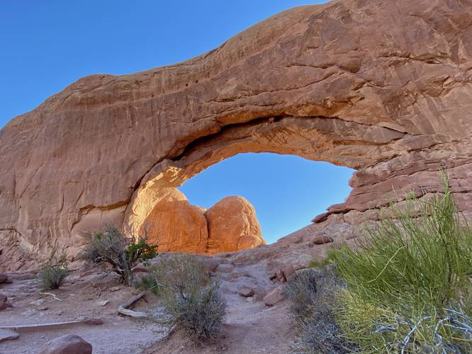
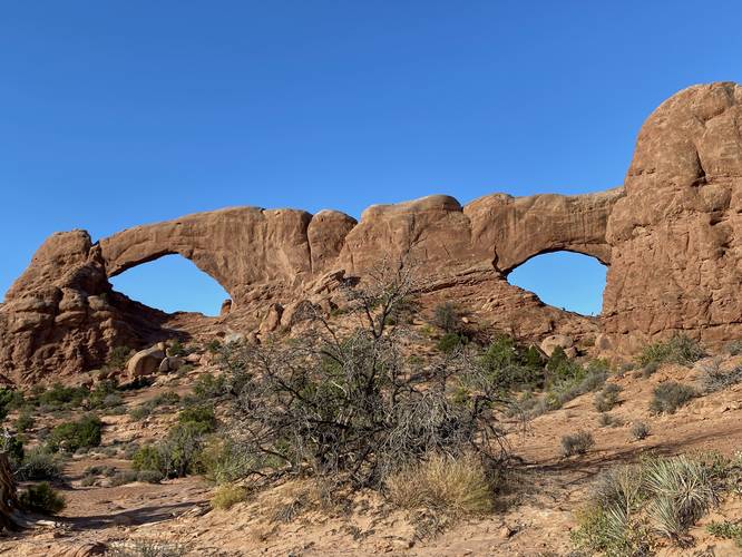
North Window Arch - Mile 0.25
Hikers will head up the short series of trail steps to reach the base of the North Window Arch around mile 0.25. There's a nice view facing eastward from the base of the arch; however, the best view is located back down the trail where you came from -- the view of North Window Arch.
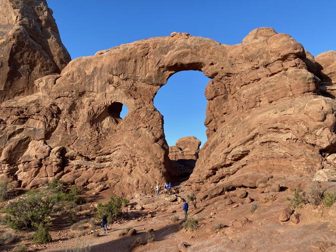
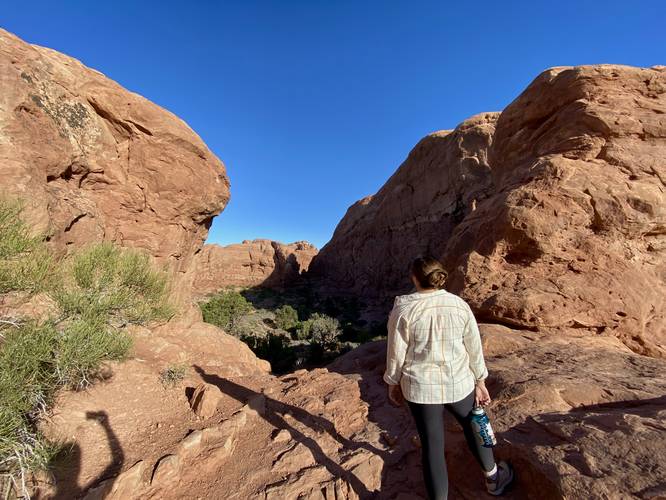
Turret Arch View - Mile 0.4
The next stop on the hike is the Turret Arch, located southwest from the North Window. Hikers will follow the path to reach the base of Turret Arch; however, on this hike we stopped before the arch itself to enjoy the rock formation from afar. Note that the Turret Arch is not the large arch/opening in the rock but rather the smaller window/arch located in the wall of the rock formation -- shaped like a gun turret, hence its name.
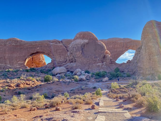
North & South Window Arch View - Mile 0.4
Before hiking onward, turn around to view the North and South Window Arches in a view together. You'll find one more view of both of these arches together if you choose to hike the complete loop; however, the western view is by far the most scenic.
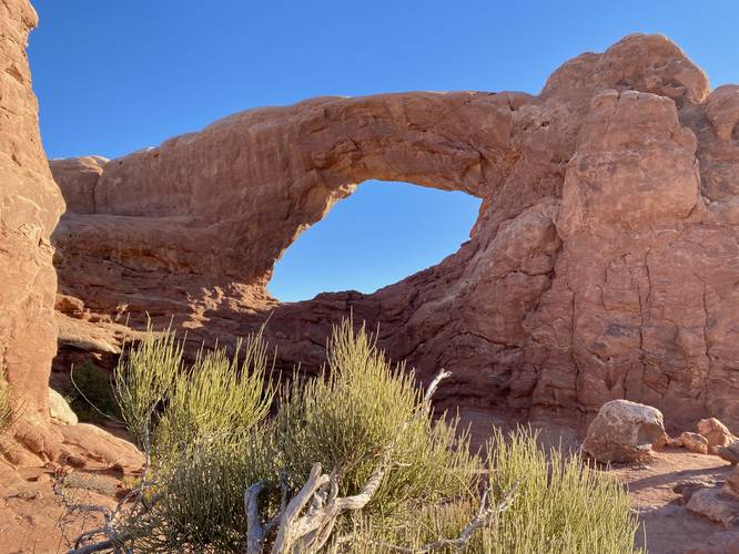
South Window Arch - Mile 0.53
The final point-of-interest (POI) on this hike is the South Window Arch, which can be best-viewed from mile 0.53. The South Window Arch is the last large arch to view on the hike and this viewing area is by far the best spot to take in the scenery. Hikers will also get a neat view of South Window from below it, on-trail as well.
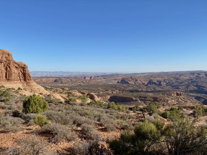
Hiking the Rugged Loop Out - Mile 0.53 to 1.2
This hike follows the loop in its entirety, which also means following the less-defined and more-rugged trail that meanders its way along sand and bedrock to make its way back to parking. Note that if you're looking for seclusion and to get away from the crowds, this section of the loop is definitely for you -- we saw no other hikers on this part of the loop despite hiking relatively slow through it. Hikers will get another view of both South and North Window Arches from the backside of the loop as well, however, the views aren't as nice as the western side. There's also one small rock scramble that hikers will encounter. After the short scramble, the trail leads down the bedrock and out along the open desert landscape to reach the parking lot.
How to Get Into Arches National Park
Note that Arches National Park, as of September 2023 (and earlier) only allows vehicles to enter the park during scheduled time slots. You can read all about Arches' timed entry here and you can find reservation information here. Reservations are grabbed quickly, so be sure to log onto the reservation website when the date opens up to grab your timed entry ticket. Note that vehicles can enter the park outside of the timed entry slots (i.e. before 7AM or after 4PM each day, as of September 2023). If you do not have a timed entry ticket between 7AM and 4PM, do not wait in line to enter the park as you will be turned away and will slow everyone else down. The vehicle line to enter the park is very long and wait-times to enter can be a pain so show up prepared.
Parking
Hikers will find a massive parking lot at the coordinates provided at the end of Windows Road in Arches National Park. The lot is large enough to fit several dozen vehicles. Parking here fills up very quickly -- generally by late morning.
Popularity
This is a very-popular hike at Arches National Park, so you'll likely see plenty of other people on the trail.
Pets
Dogs are not allowed on any trails at Arches National Park. Please do not bring your dog here.
Fees
As of September 2023, there's a $30 fee per vehicle to enter Arches National Park.
Warnings
Sun exposure: This trail has very little shade and no water sources. Pack-in all water and wear sun screen and a hat to protect against sun exposure. It's smart to hike either in the early morning or late afternoon to avoid the intense desert sun.
No water: This trail has no water sources so you must pack-in all water. A general rule of thumb in the desert is 1 gallon of water per person per day.
Rattlesnakes: This is rattlesnake territory, so be on the lookout and give any rattlers you find plenty of space.
Hike Description
This hike begins at the main (southern-most) trailhead and follows the trail as it heads eastward to reach the North Window Arch. Along the way, hikers will get immediate views of the Windows straight ahead in addition to the Turret Arch as it makes its appearance to the south as you approach the North Window Arch.
North Window Arch - Mile 0.25
Hikers will head up the short series of trail steps to reach the base of the North Window Arch around mile 0.25. There's a nice view facing eastward from the base of the arch; however, the best view is located back down the trail where you came from -- the view of North Window Arch.
Turret Arch View - Mile 0.4
The next stop on the hike is the Turret Arch, located southwest from the North Window. Hikers will follow the path to reach the base of Turret Arch; however, on this hike we stopped before the arch itself to enjoy the rock formation from afar. Note that the Turret Arch is not the large arch/opening in the rock but rather the smaller window/arch located in the wall of the rock formation -- shaped like a gun turret, hence its name.
North & South Window Arch View - Mile 0.4
Before hiking onward, turn around to view the North and South Window Arches in a view together. You'll find one more view of both of these arches together if you choose to hike the complete loop; however, the western view is by far the most scenic.
South Window Arch - Mile 0.53
The final point-of-interest (POI) on this hike is the South Window Arch, which can be best-viewed from mile 0.53. The South Window Arch is the last large arch to view on the hike and this viewing area is by far the best spot to take in the scenery. Hikers will also get a neat view of South Window from below it, on-trail as well.
Hiking the Rugged Loop Out - Mile 0.53 to 1.2
This hike follows the loop in its entirety, which also means following the less-defined and more-rugged trail that meanders its way along sand and bedrock to make its way back to parking. Note that if you're looking for seclusion and to get away from the crowds, this section of the loop is definitely for you -- we saw no other hikers on this part of the loop despite hiking relatively slow through it. Hikers will get another view of both South and North Window Arches from the backside of the loop as well, however, the views aren't as nice as the western side. There's also one small rock scramble that hikers will encounter. After the short scramble, the trail leads down the bedrock and out along the open desert landscape to reach the parking lot.
How to Get Into Arches National Park
Note that Arches National Park, as of September 2023 (and earlier) only allows vehicles to enter the park during scheduled time slots. You can read all about Arches' timed entry here and you can find reservation information here. Reservations are grabbed quickly, so be sure to log onto the reservation website when the date opens up to grab your timed entry ticket. Note that vehicles can enter the park outside of the timed entry slots (i.e. before 7AM or after 4PM each day, as of September 2023). If you do not have a timed entry ticket between 7AM and 4PM, do not wait in line to enter the park as you will be turned away and will slow everyone else down. The vehicle line to enter the park is very long and wait-times to enter can be a pain so show up prepared.
Parking
Hikers will find a massive parking lot at the coordinates provided at the end of Windows Road in Arches National Park. The lot is large enough to fit several dozen vehicles. Parking here fills up very quickly -- generally by late morning.
Popularity
This is a very-popular hike at Arches National Park, so you'll likely see plenty of other people on the trail.
Pets
Dogs are not allowed on any trails at Arches National Park. Please do not bring your dog here.
Fees
As of September 2023, there's a $30 fee per vehicle to enter Arches National Park.
Warnings
Sun exposure: This trail has very little shade and no water sources. Pack-in all water and wear sun screen and a hat to protect against sun exposure. It's smart to hike either in the early morning or late afternoon to avoid the intense desert sun.
No water: This trail has no water sources so you must pack-in all water. A general rule of thumb in the desert is 1 gallon of water per person per day.
Rattlesnakes: This is rattlesnake territory, so be on the lookout and give any rattlers you find plenty of space.