Loading...

🎉 Enjoy a Free 7-Day Supporter Trial and Unlock Exclusive Perks — No Credit Card Required. Learn more.

The Priest Hike

Directions
Map
Pictures
Send to App
Distance:
8.4 Miles / 13.5 km
Type:
Out-and-Back
Difficulty:
Strenuous
Time to Hike:
4 hours, ~12 minutes
Features:
Appalachian Trail hike
Surface Type:
Dirt
Park:
George Washington National Forest
Town:
Tyro, Virginia
Directions:
37.838311, -79.023276
Added:
February 17, 2025
Updated:
April 05, 2025
Copy Trail Link Hiking this trail? Send a friend or family member a link to this trail guide for your own safety. Hike at your own risk (disclaimer)
Loading...
Loading...
3,099'

Total Change
3,267'

Ascent
3,266'

Descent

Download the Trail Route for Offline Use

Supporters get exclusive access to download trail routes to the MyHikes app for offline use. Stay prepared on your adventure, even without an internet connection! Become a Supporter today to unlock this feature and hike with confidence.

Send to App

The Priest Hike

Many folks express great fear when thinking about hiking The Priest from VA 56. Although The Priest isn’t found on the list of the 50 highest mountains in Virginia, it rises straight up from the valley floor and forms part of an impressive skyline when driving in from the Tye River Valley. This hike involves a 3000 foot elevation gain (higher than any trail in West Virginia), however the trail is seldom steep along the way, and can be better characterized as “unrelenting” rather than difficult.  Once the trail starts climbing, it maintains a remarkably constant 13% grade for 3.6 miles before steepening slightly for the last 0.3 mile to the summit.

Coordinating with a second vehicle as a shuttle, you can combine this hike with a descent along the Crabtree Falls Trail to check off two great hiking destinations in less than 10 miles with less downhill stress on the knees (and more company) than hiking back down The Priest.

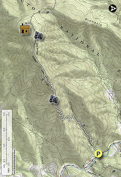
  • Mile 0.0 – The hike starts at an A.T. parking area on Virginia Route 56. The lot holds about 20 vehicles, and can be crowded on nice weekends. From this spot, southbound hikers climb The Priest and northbound hikers climb Three Ridges. Be sure to lock your vehicle and keep anything of value out of sight – stories abound of occasional break-ins here through the years. And, if climbing The Priest, go the correct way - don’t cross the highway! Enter the woods to the left of the information kiosk.
  • Mile 0.1 – Enter into The Priest Wilderness after passing the wilderness boundary sign and begin climbing. Remember, federal wilderness regulations prohibit parties of more than 10 people within wilderness areas. Leave no trace!
  • Mile 0.6 – After ascending via several switchbacks, the A.T. cuts left on an old woods road.
  • Mile 1.2 – The A.T. crosses Cripple Creek. This stream crossing can be dry in late summer or more challenging during Spring runoffs. It is your last water source before the summit.
  • Mile 2.6 – After ascending via multiple switchbacks through the mixed woods of oak and rhododendron, leaf cover gives way to a wonderful overlook to the east. Stopping for a snack and water here, while admiring the view and expressing amazement at how much elevation you have gained, is pretty much mandatory at this spot. For good reason – this overlook is nearly 2000 feet above the trailhead! The view includes Three Ridges summit to the north (left) and many area apple orchards in the valley.
  • Mile 3.9 – Reach the summit after numerous false summits and switchbacks. If you hiked here in late May or early June, you may have seen the Eastern Turkeybeard flower, which grows above 3500 feet elevation along the trail, along with a few thru-hikers. Continue on the A.T. for approximately 0.4 mile, over level ground.
  • Mile 4.3 – After passing numerous smaller trails that lead to potential campsites and dead ends, follow a well worn trail right to a large set of rocks on the western edge of the summit. These rocks give an overview to the west and north, including Three Ridges and mountains in Shenandoah National Park. By looking carefully, you can see the Blue Ridge Parkway knifing through the mountains several miles away. Return the way you came if you have a single vehicle.
  • Mile 8.4 – Return to your vehicle after following the same route back down the mountain.
By HikingUpward Contributor: Jeff Monroe
Explore 31 trails near Tyro, VA
  1. Parking

    37.838311, -79.023276
  2. Main Trailhead

    37.838311, -79.023276
No community routes found. To add your own hike as a Community Route for this Trail guide, leave a Trip Report with an attached GPX file.

Hazards

Ticks - Lyme Disease More Info (CDC)
Snakes
Poison Ivy/Oak

Seasons

All

Blaze Color

White

Trip Reports

Trail Guide By:
HikingUpward user profile picture
8.4 miles / 13.5 km

Weather Forecast

In Tyro, VA

Explore Hiking Trails

You May Also Like

New York's Best Waterfalls - Whether you're planning a day hike, roadside stop, or a leisurely short walk, this guide provides hikers, travelers, and locals alike with 63 different locations to over 100 scenic waterfalls to help plan your next adventure!
Explore

New York's Best Waterfalls

Whether you're planning a day hike, roadside stop, or a leisurely short walk, this guide provides hikers, travelers, and locals alike with 63 different locations to over 100 scenic waterfalls to help plan your next adventure!

Read
25 Best Day Hikes in North Carolina - Discover the top 25 best day hikes in North Carolina, from breathtaking waterfalls to mountain peaks. Explore hidden gems, scenic views, and trails suitable for all skill levels, perfect for your next outdoor adventure.
Explore

25 Best Day Hikes in North Carolina

Discover the top 25 best day hikes in North Carolina, from breathtaking waterfalls to mountain peaks. Explore hidden gems, scenic views, and trails suitable for all skill levels, perfect for your next outdoor adventure.

Read

Before you boogie...

Find our trail guides useful? Consider becoming a Supporter to unlock perks!

MyHikes is an indie platform that makes exploring public trails easier for everyone. The platform has no investors, no ads, and is owned and operated by one person, Dave Miller. Dave has personally mapped and written over 1,800 trail guides on MyHikes for the public to explore. MyHikes has helped millions outdoor enthusiasts plan their next adventure.

But it takes a lot of time 🕦, money 💰, work, and espresso shots ☕ to run MyHikes, including hiking , mapping , writing , and publishing new trails with high-quality (accurate) information... along with software engineering (coding) the platform like building new features, website and mobile app development (iOS and Android), site maintainance . and much much more.

Supporters unlock website and mobile app perks with an annual one-time payment of $25 (you renew) 😎👍. Or you can simply make a Donation of your choice. Otherwise, you can support us by telling your friends about MyHikes - both quick and free 🎉

Admin user profile picture

Dave Miller
MyHikes Founder