Loading...

Distance:
0.7 Miles / 1.1 km
Type:
Out-and-Back
Difficulty:
Easy
Time to Hike:
~21 minutes
Features:
Surface Type:
Dirt
Park:
Cumberland Gap National Historical Park
Town:
Ewing, Virginia
Directions:
36.600985, -83.669439
Added:
September 06, 2017
Updated:
October 25, 2018
Loading...
Loading...
121 '

Total Change
77 '

Ascent
80 '

Descent

The Tennessee Road Trail to the Iron Furnace at Cumberland Gap National Historical Park near Cumberland Gap, Virginia is an easy 0.7 mile out-and-back hike from the parking lot up to the Iron Furnace and Wilderness Road Trail and back.

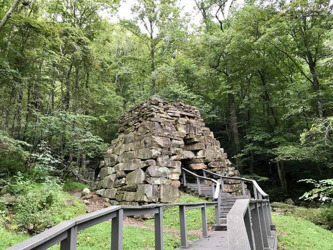
The trail head, shown on the opposite end in the GPS data, starts on the border of Tennessee and Virginia, but technically lies in Virginia. You'll pass the Iron Furnace after about 0.1 or 0.2 miles on the trail (you can't miss it) before heading up a couple of switchbacks to the Wilderness Road Trail.

Explore 4 trails near Ewing, VA
  1. Parking

    36.600985, -83.669439
  2. Main Trailhead

    36.6023, -83.669613
  3. Iron furnace

    36.601289, -83.668281
    Iron furnace
No community routes found. To add your own hike as a Community Route for this Trail guide, leave a Trip Report with an attached GPX file.

Hazards

Ticks - Lyme Disease More Info (CDC)

Season

Summer

Photo Albums

2 Trip Reports

No Star-Ratings
Trail Guide By:
Admin user profile picture
0.7 miles / 1.1 km
Trail added
September 06, 2017
Hiked on
September 02, 2017
Updated on
October 25, 2018
0.7 miles / 1.1 km
September 02, 2017
Hiking

Weather Forecast

In Ewing, VA

Explore Hiking Trails

New Hikes

Catawba Falls Trail
2.9 Miles
4.7 km
Moderate
Out-and-Back
Shortoff Trail
5.5 Miles
8.9 km
Hard
Out-and-Back
Knoll-Willows Overlook Trail
0.2 Miles
0.3 km
Easy
One-Way
Gorge Trail (Stony Brook)
0.8 Miles
1.3 km
Moderate
One-Way

Before you boogie...

Find our trail guides useful? Consider becoming a Supporter to unlock perks!

MyHikes is an indie platform that makes exploring public trails easier for everyone. The platform has no investors, runs no ads, and is owned and operated by one person, Dave Miller. Dave has personally mapped and written over 1,600 trail guides on MyHikes for the public to explore. As of 2024, MyHikes has helped over 1,300,000 outdoor enthusiasts plan their next adventure.

But it takes a lot of time 🕦, money 💰, and work, and espresso shots ☕ to run MyHikes, including hiking , mapping , writing , and publishing new trails with high-quality (accurate) information... along with software engineering (coding) the platform like building new features, site and mobile app development for iOS and Android, site maintainance . and much much more.

Supporters unlock website and mobile app perks with an annual one-time payment of $25 (you renew) 😎👍. Or you can simply make a Donation of your choice. Otherwise, you can support us by telling your friends about MyHikes - both quick and free 🎉

Admin user profile picture

Dave Miller
MyHikes Founder