Loading...

WINTER SALE! 50% OFF Supporter Accounts — now through January 31st. Learn More.

Tar Jacket Ridge Hike

The beautiful views on Tar Jacket Ridge are often overlooked with the spectacular vistas from Mount Pleasant and Cold Mountain just next door. The vista from Tar Jacket Ridge offers views of The Cardinal,The Friar, and The Little Friar. This hike is at its best as a two day backpack in the Fall or Spring when the leaves are off the trees.

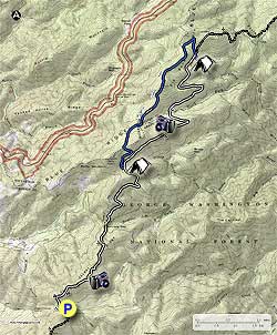
From the parking area at Log Camp Gap head north on the white blazed Appalachian Trail (AT) as it ascends Tar Jacket Ridge where in 0.5 miles you arrive at a view to the west of Big Butt and Jump Mountains west of I81. Continue to the top of Tar Jacket Ridge for one of the best vistas on this section of the AT. The vista north is of The Cardinal, The Friar, and the Little Friar; along with the views east of Mount Pleasant.

Continue down Tar Jacket Ridge for 1.1 miles where the AT crosses FR634 at Salt Log Gap. If you are doing this hike in the Fall there are numerous apple trees of different flavors here. Continue north on the AT and cross another forestry road in 1.1 miles.

From this point the AT will cross over a small spur and reach the intersection of the blue blazed Lovingston Spring Trail in another 0.5 miles. The Lovingston Spring Trail is a shorter route to the Seely/Woodworth Shelter that loops around back to the AT, and is the return route for the hike listed here.

Again continue north on the AT for 4.0 miles where you arrive at the four way intersection of the AT, Lovingston Spring Trail, and Seely/Woodworth Shelter Trail. Turn right for the short walk down to the shelter.

On the return route take the blue blazed Lovingston Spring Trail for some different scenery. The trail heads north for 0.3 miles where it makes an abrupt turn to the southwest at Twin Springs. The trail climbs over Elk Pond Mountain and in 1.3 miles passes an old hunting trailer then joins a narrow forestry road.

Continue to follow the blue blazes and forestry road for 0.5 miles where the blue blazed trail turns off the road to the right. From this intersection it is 0.2 miles before the trail crosses the same forestry road and climbs over a spur of Rocky Mountain then arriving back at the intersection of the AT.

Turn right/south on the AT to follow the trail back past Salt Log Gap, along Tar Jacket Ridge before arriving back at the parking area at Log Camp Gap.
Explore 37 trails near Vesuvius, VA

Know Before You Go

  • The 14.5-mile Tar Jacket Ridge hike in Vesuvius, VA offers scenic views of The Cardinal, The Friar, and The Little Friar, often overshadowed by nearby popular destinations.
  • The recommended two-day backpacking trip, best enjoyed in Fall or Spring, follows the white-blazed Appalachian Trail (AT) north from Log Camp Gap, incorporating a loop via the blue-blazed Lovingston Spring Trail for varied scenery.
  • The hike features diverse terrain, including ridge ascents with vistas, crossings of forestry roads (FR634), and access to the Seely/Woodworth Shelter, with potential for apple picking at Salt Log Gap in the fall.
Interactive topographic map for Tar Jacket Ridge Hike located in Vesuvius, VA. Click the "View Map" button to load GPS coordinates and trail markers.
Get directions
Distance
14.5 mi
Difficulty
Strenuous
Type
Out-and-Back
Est. Time
7.3 hrs
Elev. Gain
3,044'
Rating
4.0
Added
February 17, 2025
Updated
April 05, 2025

Weather Forecast

Tonight
Low 13°F
Isolated Snow Showers
Thursday
High 21°F
Mostly Sunny then Isolated Snow Showers
Thursday Night
Low 15°F
Mostly Clear
Friday
High 29°F
Mostly Sunny
Friday Night
Low 26°F
Mostly Cloudy
Saturday
High 35°F
Chance Light Snow
Saturday Night
Low 20°F
Chance Light Snow then Mostly Cloudy
Sunday
High 21°F
Slight Chance Light Snow
Sunday Night
Low 12°F
Mostly Clear
M.L. King Jr. Day
High 25°F
Sunny
Monday Night
Low 12°F
Partly Cloudy
Tuesday
High 19°F
Mostly Sunny
Tuesday Night
Low 11°F
Mostly Clear
Wednesday
High 29°F
Sunny
Loading...
Total Change
800'
Ascent
3,044'
Descent
3,043'
Loading...

Download the GPX Data for Offline Use

Supporters get exclusive access to download trail routes to the MyHikes app for offline use. Stay prepared on your adventure, even without an internet connection! Become a Supporter today to unlock this feature and hike with confidence.

Download Tar Jacket Ridge Hike GPX Data to the MyHikes Mobile App

Features

Vista / Lookout Point
Dogs
Mountain Summit
Camping
Water Source
Appalachian Trail logo Appalachian Trail hike

Points of interest

  1. Parking

    37.759696, -79.195594
  2. Main Trailhead

    37.759689, -79.195354

Safety information

For your own safety: plan ahead, let someone know where you'll be, and hike at your own risk.

Hazards

Snakes (Rattlesnakes, Copperheads, others)
Poison Ivy or Poison Oak

Markers

Blaze Color

White

Availability

All seasons

Surface type

Dirt

Trip Reports (Reviews)

Rated 4.0 out of 5 based on 18 ratings.

Ready to help fellow hikers? Add a trip report to share your experience and provide valuable insights for other hikers!

By: Stuart
14.5 miles / 23.3 km
November 16, 2019
Our group did this as a one-night backpack, camping at the Seeley-Woodworth Shelter. We were treated to beautiful views from Tarjacket Ridge both days. The shelter was a great place to camp with plenty of flat(ish) tent spots. The piped spring was gushing out of the mountain. The privy is a pit toilet in pretty good shape with translucent roof panels for light. We had a problem finding the 0.3mi Lovingston Spring connector trail leaving the shelter first thing in the morning. The trail was almost non-existent and obscured by newly fallen leaves. The blazes were infrequent and some were only on one side of the tree. Once we found the main Lovingston Spring Trail it was much easier to follow. The trail appears to go back and forth on private property so you probably don't want to try camping back there. And probably want to avoid it altogether during hunting season. We did it in rifle season but on a Sunday. The hunting trailer in the photos is still there but has been completely destroyed and ripped to pieces. Overall this was a great hike with great views in a less traveled area compared to Cole Mountain/Mount Pleasant.
Legacy Review
By: John
14.5 miles / 23.3 km
March 12, 2019
Following up on my prior review, we did the "front half" of the hike today - an out/back to the Wiggins Springs Road AT junction. What a great hike! The two vistas on the ridge were outstanding...and one does not need to leave the AT to reach them. They just appear. Great views of Mt. Pleasant, the bald on top of Cold Mountain, Jump Mountain and the religious range. The ascent up the sou h slope is much easier than the return ascent up the north slope (which was draining). The USFS has done some bush-hogging around the vistas to keep the scrub down which otherwise might block the views. The AT was the AT...always a pleasure. This goes on our list for a late fall do-over where the colors should be terrific. Registered 6.8 miles with 1,600' of ascent. Between the two hikes, 17.3 miles w/ 3,800' ascent vs HU's 14.9 miles w/ 3,150' ascent. As we duplicated the out/back between Salt Log Gap and Wiggins Springs Road - 2.5 miles w/ 500' ascent, the stats line up nicely. Looking forward to doing this one again.
Legacy Review
By: John
14.5 miles / 23.3 km
March 07, 2019
Did an abridged version as a day hike starting at Salt Log Gap and hiking the loop to the north - will save the Tar Jacket Ridge portion for another day. Hiking on the AT has always been a pleasure - this 5 mile stretch to the Seely Shelter was no exception. We connected easily to the LST for the return trip and found it very pleasant although it could use some new blazes. We blew the turnoff mentioned in the hike description and, even more amazingly, did not notice the trail crossing over the fire road a bit later. By that time, my GPS was telling me that I was off-track and I finally listened. We bushwhacked less than 100' to the LST and followed it down to the AT junction and home. Great hike. 10.8 miles which would be a bit less if we had paid attention to the hike description on this website. 2,200' of ascent which is quite a bit for our group but there was really no steep ascents...fairly pleasant gradual ascents. We'll do it again next year and follow the instructions this time.
Legacy Review
No community routes found. To add your own hike as a Community Route for this Trail guide, leave a Trip Report with an attached GPX file.

Popular categories

Scenic mountain view representing vista trails
Vista trails
Scenic gorge of cascades representing waterfall trails
Waterfall hikes
Rugged mountain terrain representing summit trails
Summit trails
Scenic mountain view representing dog-friendly trails
Dog-friendly
Scenic campsite with a view representing camping trails
Camping trails
Appalachian Trail logo representing A.T. hikes
A.T. hikes

You May Also Like

25 Best Day Hikes in North Carolina - Discover the top 25 best day hikes in North Carolina, from breathtaking waterfalls to mountain peaks. Explore hidden gems, scenic views, and trails suitable for all skill levels, perfect for your next outdoor adventure.
Explore

25 Best Day Hikes in North Carolina

Discover the top 25 best day hikes in North Carolina, from breathtaking waterfalls to mountain peaks. Explore hidden gems, scenic views, and trails suitable for all skill levels, perfect for your next outdoor adventure.

Read
🍪 We use cookies to learn about site usage and to serve map tiles. You may block cookies manually in the browser. By continuing you agree. Learn more