Loading...

🍂 Prep for Fall! Unlock exclusive features to plan your perfect late-summer and autumn hikes — become a Supporter today. Learn more.

Sweet Run State Park Hike

Directions
Map
Pictures
Send to App
Distance:
5.6 Miles / 9.0 km
Type:
Loop
Difficulty:
Moderate
Time to Hike:
2 hours, ~48 minutes
Features:
Surface Type:
Dirt
Town:
Neersville, Virginia
Directions:
39.29388, -77.724953
Added:
April 03, 2025
Updated:
April 06, 2025
Guide by:
Copy Trail Link Hiking this trail? Send a friend or family member a link to this trail guide for your own safety. Hike at your own risk (disclaimer)
Loading...
Loading...
197'

Total Change
736'

Ascent
730'

Descent

Download the Trail Route for Offline Use

Supporters get exclusive access to download trail routes to the MyHikes app for offline use. Stay prepared on your adventure, even without an internet connection! Become a Supporter today to unlock this feature and hike with confidence.

Send to App

Key Takeaways

  • Sweet Run State Park in Neersville, VA, offers 5.6 miles of hiking with diverse scenery including a wildlife pond, historic homesteads, wetlands, and Piney Run.
  • The park features interconnected trail loops ranging from 1.8 to 6.2 miles, accessible from the main trailhead, allowing for customizable hikes.
  • A printed trail map is recommended to navigate the intertwining paths and fully appreciate the park's scenic highlights like the Old Bridge Trail lunch spot and wetlands.

Sweet Run State Park Hike

Sweet Run State Park has seven different loops of intertwining trails. With a wildlife pond, historic homesteads, wetlands, and Piney Run, this area offers something for everyone. Make sure to bring your camera, because there are pictures around every corner at the Sweet Run State Park.

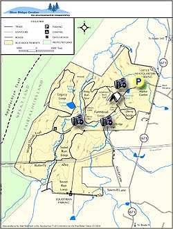
All the trails are accessed from the main trailhead, 100 yards from the parking area where the gravel road splits to the right. With multiple different circuits possible, from the shorter 1.8 mile Farmstead Loop passing a wildlife pond, valley views, two old homesteads, and several pastures, to combining that circuit with several of the higher mountain loops to form a 6.2 mile perimeter hike.

Piney Run passes through the middle of the property, on its way to the Potomac River. The run has a beautiful lunch spot on a small island where the Old Bridge Trail crosses it, as well as a large wetlands area that is visible from both the Piney Spur Trail, and Legacy Loop.

But whichever combination of trails you decide to do, make sure to print the trail map, as you might miss something beautiful in this labyrinth.

Explore 32 trails near Neersville, VA
  1. Parking

    39.29388, -77.724953
  2. Main Trailhead

    39.294117, -77.724967
No community routes found. To add your own hike as a Community Route for this Trail guide, leave a Trip Report with an attached GPX file.

Hazards

Ticks - Lyme Disease More Info (CDC)
Snakes
Poison Ivy/Oak

Seasons

All

Photo Albums

+ Add Photo Album

Upload your photos from the trail to help others know what to expect.

Trip Reports (Reviews)

Rated 3.21 out of 5 based on 19 ratings.
By: SB
5.6 miles / 9.0 km
October 07, 2018
The hike was decent enough and the trails were maintained well enough but they were not clearly marked. There were blazes but no indication which trail was which. I came to a couple of intersections and all there would be was a sign with the equestrian symbol and nothing else which did not help me decipher which way I was supposed to go. I had a copy of the trail map and all the trails intersect so more clearly marked signs would have been very helpful. Also, unfortunately due to all the rain we've received the trails are still very muddy and some were even flooded. Still a very pretty place to saunter thru the woods.
Legacy Review
By: aldikuma
5.6 miles / 9.0 km
November 18, 2016
The signage is good, directing you to two parking areas - one by the gardens and one a bit further down the road and down the hill across from the trailhead. The trails are well marked and maintained and it's easy to navigate, with not much elevation change. The ponds and historic cabins are a nice break in the scenery, and there's a few camping spots to take a break if you need. Overall, this wasn't a bad hike as you get the solitude and quiet, but I didn't feel a good vibe here. Perhaps it was the fresh chicken head placed at the trailhead (sad), or the burgundy sedan that sped me off the narrow road as I was leaving, or the fact that you can only hike between 10am-3pm on most days Oct-Nov due to hunting (BE SURE you follow this timeframe carefully), but I won't be returning. Ironically, I didn't see one deer or any other wildlife the entire time I was out here, and I hiked most of it.
Legacy Review
By: Rob
5.6 miles / 9.0 km
July 02, 2016
Very pleasant and secluded hike. Not challenging at all but nice, thick, dense forest next to a pleasant creek.
Legacy Review

Weather Forecast

In Neersville, VA

Explore Hiking Trails

You May Also Like

New York's Best Waterfalls - Whether you're planning a day hike, roadside stop, or a leisurely short walk, this guide provides hikers, travelers, and locals alike with 63 different locations to over 100 scenic waterfalls to help plan your next adventure!
Explore

New York's Best Waterfalls

Whether you're planning a day hike, roadside stop, or a leisurely short walk, this guide provides hikers, travelers, and locals alike with 63 different locations to over 100 scenic waterfalls to help plan your next adventure!

Read
25 Best Day Hikes in North Carolina - Discover the top 25 best day hikes in North Carolina, from breathtaking waterfalls to mountain peaks. Explore hidden gems, scenic views, and trails suitable for all skill levels, perfect for your next outdoor adventure.
Explore

25 Best Day Hikes in North Carolina

Discover the top 25 best day hikes in North Carolina, from breathtaking waterfalls to mountain peaks. Explore hidden gems, scenic views, and trails suitable for all skill levels, perfect for your next outdoor adventure.

Read

Before you boogie...

Find our trail guides useful? Consider becoming a Supporter to unlock perks!

MyHikes is an indie platform that makes exploring public trails easier for everyone. The platform has no investors, no ads, and is owned and operated by one person, Dave Miller. Dave has personally mapped and written over 1,800 trail guides on MyHikes for the public to explore. MyHikes has helped millions outdoor enthusiasts plan their next adventure.

But it takes a lot of time 🕦, money 💰, work, and espresso shots ☕ to run MyHikes, including hiking , mapping , writing , and publishing new trails with high-quality (accurate) information... along with software engineering (coding) the platform like building new features, website and mobile app development (iOS and Android), site maintainance . and much much more.

Supporters unlock website and mobile app perks with an annual one-time payment of $25 (you renew) 😎👍. Or you can simply make a Donation of your choice. Otherwise, you can support us by telling your friends about MyHikes - both quick and free 🎉

Admin user profile picture

Dave Miller
MyHikes Founder