Loading...

Distance:
0.3 Miles / 0.5 km
Type:
One-Way
Difficulty:
Moderate
Time to Hike:
~9 minutes
Features:
Surface Type:
Dirt
Park:
Lands End
Town:
San Francisco, California
Directions:
37.780272, -122.511292
Added:
September 27, 2018
Updated:
January 25, 2024
Loading...
Loading...
100 '

Total Change
100 '

Ascent
100 '

Descent

The Sutro Baths Upper Trail to Point Lobos in San Francisco, California is a moderate 0.3 mile one-way trail that starts along the Coastal Trail at Lands End and heads out to Point Lobos before climbing back up to the parking lot.

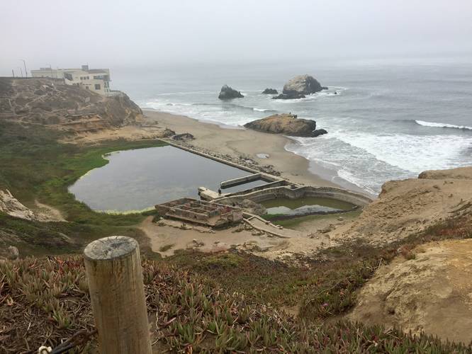
This trail has stunning views of the coastal cliffs along with the ruins of the Sutro Baths below. The hike starts off heading downhill from either trailhead. If you plan to hike this trail in the opposite direction, make sure to stay right at the trail junction after the initial staircase down towards the Sutro Baths. If you start this hike from the trailhead listed here, just continue along the trail, through the cypress trees, until you reach a large concrete lookout point - Point Lobos.

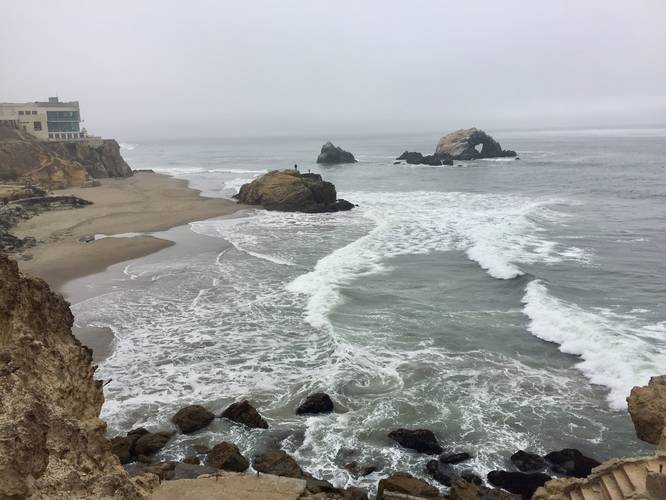
Continuing on from Point Lobos, you'll hike along cliff edges before hitting a trail junction that leads up a set of stairs back to the parking lot.

Warning: Cliff hike, watch your step!

Explore 26 trails near San Francisco, CA
  1. Parking

    37.780272, -122.511292
  2. Main Trailhead

    37.781579, -122.512208
  3. View / Overlook / Vista

    37.781075, -122.513267
    View / Overlook / Vista
  4. View / Overlook / Vista

    37.780933, -122.514336
    View / Overlook / Vista
No community routes found. To add your own hike as a Community Route for this Trail guide, leave a Trip Report with an attached GPX file.

Hazards

Ticks - Lyme Disease More Info (CDC)

Seasons

All

Photo Albums

1 Trip Report

No Star-Ratings
Trail Guide By:
Admin user profile picture
0.3 miles / 0.5 km
Trail added
September 27, 2018
Hiked on
September 25, 2018
Updated on
January 25, 2024

Weather Forecast

In San Francisco, CA

Explore Hiking Trails

New Hikes

Boulder Falls Trail
0.2 Miles
0.3 km
Moderate
Out-and-Back
State Camp CCC Trail
0.7 Miles
1.1 km
Easy
Loop
Catawba Falls Trail
2.9 Miles
4.7 km
Moderate
Out-and-Back
Lower Stony Brook Falls
0.2 Miles
0.3 km
Easy
Out-and-Back

Before you boogie...

Find our trail guides useful? Consider becoming a Supporter to unlock perks!

MyHikes is an indie platform that makes exploring public trails easier for everyone. The platform has no investors, runs no ads, and is owned and operated by one person, Dave Miller. Dave has personally mapped and written over 1,600 trail guides on MyHikes for the public to explore. As of 2024, MyHikes has helped over 1,300,000 outdoor enthusiasts plan their next adventure.

But it takes a lot of time 🕦, money 💰, and work, and espresso shots ☕ to run MyHikes, including hiking , mapping , writing , and publishing new trails with high-quality (accurate) information... along with software engineering (coding) the platform like building new features, site and mobile app development for iOS and Android, site maintainance . and much much more.

Supporters unlock website and mobile app perks with an annual one-time payment of $25 (you renew) 😎👍. Or you can simply make a Donation of your choice. Otherwise, you can support us by telling your friends about MyHikes - both quick and free 🎉

Admin user profile picture

Dave Miller
MyHikes Founder