Located in Pennsylvania’s Michaux State Forest, Sunset Rocks includes many unique attractions along the trail, including 200-year-old buildings from the early days of Pennsylvania’s iron-working industry, artifacts from the Appalachian Trail’s construction at the Appalachian Trail Museum, and the chance for a stimulating ridgeline rock scramble to the Sunset Rocks themselves.
This trail can also be hiked in conjunction with the Camp Michaux trail, which explores the ruins of a former Civilian Conservation Corps (CCC) camp used to house German and Japanese prisoners of war during World War II.
Note – The 0.4 mile rock scramble section includes several sections that require crossing over and climbing/descending through rock crevasses similar to those on Old Rag. This section of trail can be challenging for people with limited physical strength or mobility.
- Mile 0.0 – Walk uphill from the Appalachian Trail (AT) Parking area to the Appalachian Trail Museum. Turn left at the AT signpost and follow the white AT blazes along Bendersville Lane past the Pine Grove General Store and historic Ironmaster’s Mansion. Continue following the AT blazes as Bendersville Lane merges with Pine Grove Road.
- Mile 0.4 – Turn right as the AT leaves Pine Grove Road onto a gravel drive. The trail goes uphill past several cabins before entering Michaux State Forest.
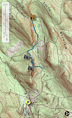
- Mile 1.6 – Sunset Rocks Trail meets the AT from the left. Keep right and continue following the AT as it crosses a short footbridge over Toms Run.
- Mile 1.8 – The AT briefly joins a gravel road for ~100 yards before leaving it to the right on a newly added section of trail. Turn right off the gravel road and continue on the AT. Note - older maps will show the AT following the road out to Michaux Road.
- Mile 2.5 – The AT follows the new section of trail uphill through several large blackberry thickets to a small parking lot on Michaux Road. Cross the road and continue following the AT.
- Mile 3.4 – The trail passes the Appalachian Trail Halfway Marker, which marks the approximate halfway point between either end of the AT. The exact halfway point between Georgia and Maine changes each year due to detours and shifts in the AT’s route along its ~2,200 mile length, but despite this the midpoint has remained relatively close to the marker’s present location.
- Mile 3.6 – The AT passes by Toms Run Shelter. Approximately 100 yards past the shelter the trail crosses a stream before reaching an intersection with the blue-blazed Sunset Rocks Trail. Turn left onto Sunset Rocks Trail. The trail heads east along the remains of an old forest road.
- Mile 4.3 – The trail passes by a small clearing to the left. From this point you can choose to detour onto the ~2 mile Camp Michaux Trail and explore the ruins of an abandoned CCC camp used to house POWs during World War II. Please see the Camp Michaux Trail page for details. Otherwise, keep right and continue following the Sunset Rocks Trail.
- Mile 4.7 – Turn right as the trail joins with Michaux Road. Continue following the blue trail blazes along the road for ~300 yards.
- Mile 4.9 – The trail leaves Michaux Road to the left and heads uphill towards Little Rocky Ridge.
- Mile 5.2 – The trail switchbacks to a small viewpoint before following the ridgeline in a series of Old Rag-style rock scrambles across and around boulders and pinnacles.
- Mile 5.6 – After the rock scramble the trail comes to an intersection. Straight ahead is a ~100 yard side trail to the eponymous Sunset Rocks and a panoramic view to the south. After enjoying the view, return to the intersection and continue following the main trail as it steeply descends into the valley.
- Mile 6.1 – Sunset Rocks Trail ends at the intersection with the AT previously passed at Mile 1.6. Turn right and rejoin the AT to return to Pine Grove Furnace.
- Mile 7.3 – Turn left and follow the AT along Pine Grove Road. In ~200 yards turn right onto Bendersville Lane.
- Mile 7.6 – Return to the Pine Grove Furnace AT parking area and the trail start.