Loading...

๐ŸŽ‰ Enjoy a Free 7-Day Supporter Trial and Unlock Exclusive Perks โ€” No Credit Card Required. Learn more.

Sunrise Point Trail

Directions
Map
Pictures
Send to App
Distance:
0.3 Miles / 0.5 km
Type:
Out-and-Back
Difficulty:
Easy
Time to Hike:
~9 minutes
Features:
Surface Type:
Dirt
Park:
Dimple Dell Park
Town:
Sandy, Utah
Directions:
40.570238, -111.807587
Added:
May 31, 2024
Updated:
June 19, 2024
Copy Trail Link Hiking this trail? Send a friend or family member a link to this trail guide for your own safety. Hike at your own risk (disclaimer)
Loading...
Loading...
74'

Total Change
75'

Ascent
75'

Descent

Download the Trail Route for Offline Use

Supporters get exclusive access to download trail routes to the MyHikes app for offline use. Stay prepared on your adventure, even without an internet connection! Become a Supporter today to unlock this feature and hike with confidence.

Send to App

Sunrise Point Trail

The Sunrise Point Trail at Dimple Dell Park in Sandy, Utah is an easy 0.3-mile out-and-back hike that features beautiful mountain and meadow views.

Hike
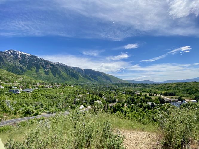
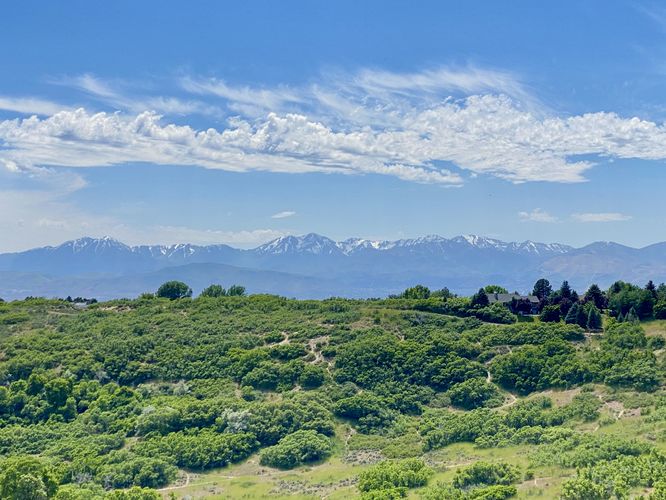
This very short hike begins at the main parking lot for Dimple Dell Park, located near the junction of Mt Jordan Road and Dimple Dell Road. The trailhead for the Sunrise Point Trail might be a little hard to notice as it's the middle trail that sits between two more-obvious pathways. You may accidentally start walking down a nice wide trail -- that's not the Sunrise Point Trail. Simply look for the dark brown sign post with overgrown grass surrounding it and faint letters of "Sunrise Point". Follow this very-skinny trail as it leads south downhill to reach Sunrise Point. Along the way are views of Sandy, Utah's houses nestled within the foothills of the larger mountains in the distance. You can also get views westward toward South Mountain or southward toward Draper, Utah. Hikers will eventually reach the end of the trail at Sunrise Point, around mile 0.17. Here, you'll find similar views that the trail offered on the way in along with an informational kiosk on how Little Cottonwood Canyon was formed by glaciers 10,000 to 30,000 years ago. After exploring Sunrise Point, the hike leads back uphill to parking for a very short 0.3-mile jaunt.

Parking
Hikers will find a very large parking lot a the coordinates provided, located near the junction of Mt Jordan Road and Dimple Dell Road in Sandy, Utah. The lot is large enough to fit a couple dozen vehicles as of May 2024.

Pets
Dogs are allowed only if leashed and must be cleaned up after.
Explore 19 trails near Sandy, UT
  1. Parking

    40.570238, -111.807587
  2. Main Trailhead

    40.570002, -111.807687
  3. Snow-capped mountain views toward Mount Baldy

    40.5686, -111.807647
    Snow-capped mountain views toward Mount Baldy
  4. Snow-capped mountain views toward Mount Baldy

    40.567786, -111.807106
    Snow-capped mountain views toward Mount Baldy
  5. View toward Draper, Utah

    40.567786, -111.807106
    View toward Draper, Utah
  6. View toward South Mountain area

    40.567803, -111.807175
    View toward South Mountain area
No community routes found. To add your own hike as a Community Route for this Trail guide, leave a Trip Report with an attached GPX file.

Hazards

Snakes

Seasons

All

Photo Albums

Trip Reports

Trail Guide By:
Admin user profile picture
0.3 miles / 0.5 km
Preview of the MyHikes mobile app interface

Track, Log, and Explore Hikes with the MyHikes App

Shop Landscape Prints
Shop our landscape prints from popular locations around Utah

Weather Forecast

In Sandy, UT

Explore Hiking Trails

You May Also Like

Colorado's Million Dollar Highway - Plan a day's drive adventure along the iconic Million Dollar Highway in Colorado. Explore the best short trails, roadside stops, waterfalls, vistas, ghost towns, and hot springs within a ~6 hour road trip.
Explore

Colorado's Million Dollar Highway

Plan a day's drive adventure along the iconic Million Dollar Highway in Colorado. Explore the best short trails, roadside stops, waterfalls, vistas, ghost towns, and hot springs within a ~6 hour road trip.

Read
Glacier's Going-to-the-Sun Road - Discover the breathtaking beauty of Glacier National Park along the iconic Going-to-the-Sun Road. From stunning roadside stops to picturesque waterfalls and vistas, this engineering marvel offers endless opportunities for exploration.
Explore

Glacier's Going-to-the-Sun Road

Discover the breathtaking beauty of Glacier National Park along the iconic Going-to-the-Sun Road. From stunning roadside stops to picturesque waterfalls and vistas, this engineering marvel offers endless opportunities for exploration.

Read
New York's Best Waterfalls - Whether you're planning a day hike, roadside stop, or a leisurely short walk, this guide provides hikers, travelers, and locals alike with 63 different locations to over 100 scenic waterfalls to help plan your next adventure!
Explore

New York's Best Waterfalls

Whether you're planning a day hike, roadside stop, or a leisurely short walk, this guide provides hikers, travelers, and locals alike with 63 different locations to over 100 scenic waterfalls to help plan your next adventure!

Read

Before you boogie...

Find our trail guides useful? Consider becoming a Supporter to unlock perks!

MyHikes is an indie platform that makes exploring public trails easier for everyone. The platform has no investors, no ads, and is owned and operated by one person, Dave Miller. Dave has personally mapped and written over 1,800 trail guides on MyHikes for the public to explore. MyHikes has helped millions outdoor enthusiasts plan their next adventure.

But it takes a lot of time ๐Ÿ•ฆ, money ๐Ÿ’ฐ, work, and espresso shots โ˜• to run MyHikes, including hiking , mapping , writing , and publishing new trails with high-quality (accurate) information... along with software engineering (coding) the platform like building new features, website and mobile app development (iOS and Android), site maintainance . and much much more.

Supporters unlock website and mobile app perks with an annual one-time payment of $25 (you renew) ๐Ÿ˜Ž๐Ÿ‘. Or you can simply make a Donation of your choice. Otherwise, you can support us by telling your friends about MyHikes - both quick and free ๐ŸŽ‰

Admin user profile picture

Dave Miller
MyHikes Founder