Loading...

๐Ÿ Fall is here! Check out our foliage map to plan your autumn hikes! Learn more.

Summit Peak Tower Trail

Directions
Map
Pictures
Send to App
Distance:
1.0 Mile / 1.6 km
Type:
Out-and-Back
Difficulty:
Moderate
Time to Hike:
~30 minutes
Features:
Surface Type:
Dirt
Park:
Porcupine Mountains Wilderness State Park
Town:
LaFayette Landing, Michigan
Get Directions:
46.743501, -89.771288
Added:
September 25, 2022
Updated:
October 04, 2022
Copy Trail Link Hiking this trail? Send a friend or family member a link to this trail guide for your own safety. Hike at your own risk (disclaimer)
Loading...
Loading...
215'

Total Change
245'

Ascent
245'

Descent

Download the Trail Route for Offline Use

Supporters get exclusive access to download trail routes to the MyHikes app for offline use. Stay prepared on your adventure, even without an internet connection! Become a Supporter today to unlock this feature and hike with confidence.

Send to App

Key Takeaways

  • The Summit Peak Tower Trail is a 1-mile out-and-back moderate hike in Porcupine Mountains Wilderness State Park near LaFayette Landing, MI.
  • The trail features stairs and an observation tower, offering vista points with views of the Porcupine Mountains.
  • The trailhead is located on the north side of the circular parking lot, and dogs are allowed on a leash.

Summit Peak Tower Trail

The Summit Peak Tower Trail at Porcupine Mountains Wilderness State Park near LaFayette Landing, Michigan is a moderate 1-mile out-and-back hike that leads to two vista points with views of the Porcupine Mountains, one of which sits at the top of an observation tower.

Hike Description
This hike begins at the main trailhead, located on the north side of the circular parking lot. The trail heads uphill immediately and follows a bend to reduce the quick elevation change (note I skipped that in the GPS recording provided).

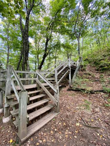
Stairs Begin - Mile 0.3
Around mile 0.3, hikers will reach a staircase that continues the ascent up to Summit Peak.

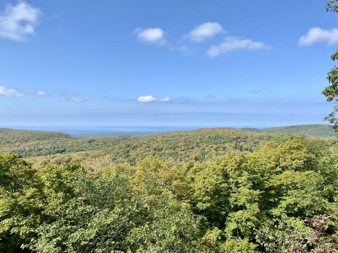
Observation Vista - Mile 0.35
Along the way is an observation platform, located down a couple sets of stairs which provides views facing north into the Porcupine Mountains. After enjoying this view, hikers will continue up more stairs to reach the tower.

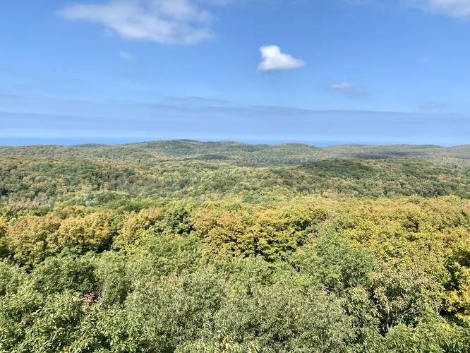
Summit Peak Tower & Vista - Mile 0.5
At mile 0.5, hikers will reach the Summit Peak Tower which includes about 4 sets of staircases that lead to the top. From the top, hikers will get a 180-degree view of the surrounding Porcupine Mountains from just above the tree canopy. A keen-eyed hiker may spot the cliffs of the Lake of the Clouds Accessible Overlook.

Parking
Hikers will find a large parking lot which is spread out in segments around a large one-way driving circle, as of September 2022.

Pets
Dogs are allowed if leashed and their waste must be carried out by the hiker.
Explore 4 trails near LaFayette Landing, MI
  1. Parking

    46.743501, -89.771288
  2. Main Trailhead

    46.743698, -89.771177
  3. Stairs begin leading up to Summit Peak Tower

    46.746344, -89.774139
    Stairs begin leading up to Summit Peak Tower
  4. View from Summit Peak Tower

    46.747806, -89.771872
    View from Summit Peak Tower
  5. Vista of the Porcupine Mountains from boardwalk

    46.747075, -89.774186
    Vista of the Porcupine Mountains from boardwalk
No community routes found. To add your own hike as a Community Route for this Trail guide, leave a Trip Report with an attached GPX file.

Hazards

Ticks - Lyme Disease More Info (CDC)
Poison Ivy/Oak

Seasons

All

Photo Albums

+ Add Photo Album

Upload your photos from the trail to help others know what to expect.

Preview of the MyHikes mobile app interface

Track, Log, and Explore Hikes with the MyHikes App

Explore Autumn Foliage

No Change
Some Color
Low Color
Moderate Color
High Color
Peak Color
Past Peak
Sept 1 Sept 8 Sept 15 Sept 22 Sept 29 Oct 6 Oct 13 Oct 20 Oct 27 Nov 3 Nov 10 Nov 17 Nov 24

Trip Reports (Reviews)

Ready to help fellow hikers? Add a trip report to share your experience and provide valuable insights for those planning their next hike. Your review makes the trail better for everyone.

Rated 4.0 out of 5 based on 1 rating.
1.0 mile / 1.6 km
September 21, 2022
Hiking

Weather Forecast

In LaFayette Landing, MI

Explore Hiking Trails

You May Also Like

Colorado's Million Dollar Highway - Plan a day's drive adventure along the iconic Million Dollar Highway in Colorado. Explore the best short trails, roadside stops, waterfalls, vistas, ghost towns, and hot springs within a ~6 hour road trip.
Explore

Colorado's Million Dollar Highway

Plan a day's drive adventure along the iconic Million Dollar Highway in Colorado. Explore the best short trails, roadside stops, waterfalls, vistas, ghost towns, and hot springs within a ~6 hour road trip.

Read
Glacier's Going-to-the-Sun Road - Discover the breathtaking beauty of Glacier National Park along the iconic Going-to-the-Sun Road. From stunning roadside stops to picturesque waterfalls and vistas, this engineering marvel offers endless opportunities for exploration.
Explore

Glacier's Going-to-the-Sun Road

Discover the breathtaking beauty of Glacier National Park along the iconic Going-to-the-Sun Road. From stunning roadside stops to picturesque waterfalls and vistas, this engineering marvel offers endless opportunities for exploration.

Read
New York's Best Waterfalls - Whether you're planning a day hike, roadside stop, or a leisurely short walk, this guide provides hikers, travelers, and locals alike with 63 different locations to over 100 scenic waterfalls to help plan your next adventure!
Explore

New York's Best Waterfalls

Whether you're planning a day hike, roadside stop, or a leisurely short walk, this guide provides hikers, travelers, and locals alike with 63 different locations to over 100 scenic waterfalls to help plan your next adventure!

Read

Before you boogie...

Find our trail guides useful? Consider becoming a Supporter to unlock perks!

MyHikes is an indie platform that makes exploring public trails easier for everyone. The platform has no investors, no ads, and is owned and operated by one person, Dave Miller. Dave has personally mapped and written over 1,800 trail guides on MyHikes for the public to explore. MyHikes has helped millions outdoor enthusiasts plan their next adventure.

But it takes a lot of time ๐Ÿ•ฆ, money ๐Ÿ’ฐ, work, and espresso shots โ˜• to run MyHikes, including hiking , mapping , writing , and publishing new trails with high-quality (accurate) information... along with software engineering (coding) the platform like building new features, website and mobile app development (iOS and Android), site maintainance . and much much more.

Supporters unlock website and mobile app perks with an annual one-time payment of $25 (you renew) ๐Ÿ˜Ž๐Ÿ‘. Or you can simply make a Donation of your choice. Otherwise, you can support us by telling your friends about MyHikes - both quick and free ๐ŸŽ‰

Admin user profile picture

Dave Miller
MyHikes Founder