Loading...

WINTER SALE! 50% OFF Supporter Accounts — now through January 31st. Learn More.

Lake of the Clouds Accessible Overlook

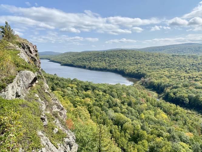
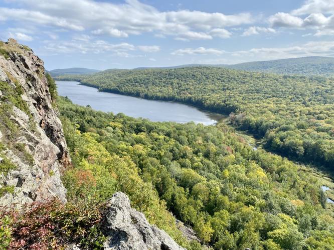
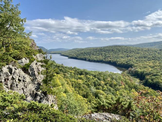
The Lake of the Clouds Accessible Overlook at Porcupine Mountains Wilderness State Park near Ontonagon, Michigan is an easy 0.4-mile out-and-back trail that leads along a universally accessible trail and features some of the best views of the Lake of the Clouds and the Porcupine Mountains.

This is less of a hike and more of a short accessible walk that leads out to the mountain ledges with stunning views. This trail is by far the most popular at the Porcupine Mountains and for good reason - it's easy to follow, close to the parking lot, and is fully accessible to everyone. The boardwalk portion of the trail passes along the edge of the mountain's cliffs which provide stunning views of the Lake of the Clouds, the Big Carp River, and adjacent mountain cliffs.

Highly-Trafficked
This scenic overlook is one of the most popular trails in the area, so expect a crowd unless you show up when the park opens. During peak foliage, the park can be overloaded with visitors (hence the large parking lot), so plan accordingly.

Parking & Fees
Visitors will find a very large parking lot at the coordinates provided that can fit several dozen vehicles. As of September 2022, there's a $10 entrance fee.

Pets
Dogs are allowed if leashed and their waste must be carried out by the hiker.

Warnings
Ledges: The trail leads along very steep cliffs, but provides a safety fence the entire way.
Explore 4 trails near Ontonagon, MI

Know Before You Go

  • The Lake of the Clouds Accessible Overlook is an easy, 0.4-mile accessible trail offering stunning views of the lake, river, and mountains.
  • Located in Porcupine Mountains Wilderness State Park (Ontonagon, MI), the overlook is highly popular and can get crowded, especially during peak foliage season.
  • Visitors should expect a $10 entrance fee and dogs are permitted on leashes, but waste must be removed; the trail is fenced due to steep cliffs.
Interactive topographic map for Lake of the Clouds Accessible Overlook located in Ontonagon, MI. Click the "View Map" button to load GPS coordinates and trail markers.
Get directions
Distance
0.4 mi
Difficulty
Easy
Type
Out-and-Back
Est. Time
12 min
Elev. Gain
40'
Rating
5.0
Added
September 25, 2022
Updated
September 29, 2022

Weather Forecast

Loading...
Total Change
37'
Ascent
40'
Descent
40'
Loading...

Download the GPX Data for Offline Use

Supporters get exclusive access to download trail routes to the MyHikes app for offline use. Stay prepared on your adventure, even without an internet connection! Become a Supporter today to unlock this feature and hike with confidence.

Download Lake of the Clouds Accessible Overlook GPX Data to the MyHikes Mobile App

Features

Vista / Lookout Point
Dogs

Points of interest

  1. Parking

    46.803712, -89.76581
  2. Main Trailhead

    46.803666, -89.765646
  3. View of the Lake of the Clouds

    46.802825, -89.765097
    View of the Lake of the Clouds
  4. View of the Lake of the Clouds

    46.802794, -89.765144
    View of the Lake of the Clouds

Safety information

For your own safety: plan ahead, let someone know where you'll be, and hike at your own risk.

Hazards

Rockfalls, Ledges, or Scrambles

Availability

All seasons

Surface type

Universal Access

Trip Reports (Reviews)

Rated 5.0 out of 5 based on 1 rating.

Ready to help fellow hikers? Add a trip report to share your experience and provide valuable insights for other hikers!

0.4 miles / 0.6 km
September 21, 2022
Hiking
No community routes found. To add your own hike as a Community Route for this Trail guide, leave a Trip Report with an attached GPX file.

Popular categories

Scenic mountain view representing vista trails
Vista trails
Scenic gorge of cascades representing waterfall trails
Waterfall hikes
Rugged mountain terrain representing summit trails
Summit trails
Scenic mountain view representing dog-friendly trails
Dog-friendly
Scenic campsite with a view representing camping trails
Camping trails
Appalachian Trail logo representing A.T. hikes
A.T. hikes

You May Also Like

Colorado's Million Dollar Highway - Plan a day's drive adventure along the iconic Million Dollar Highway in Colorado. Explore the best short trails, roadside stops, waterfalls, vistas, ghost towns, and hot springs within a ~6 hour road trip.
Explore

Colorado's Million Dollar Highway

Plan a day's drive adventure along the iconic Million Dollar Highway in Colorado. Explore the best short trails, roadside stops, waterfalls, vistas, ghost towns, and hot springs within a ~6 hour road trip.

Read
Glacier's Going-to-the-Sun Road - Discover the breathtaking beauty of Glacier National Park along the iconic Going-to-the-Sun Road. From stunning roadside stops to picturesque waterfalls and vistas, this engineering marvel offers endless opportunities for exploration.
Explore

Glacier's Going-to-the-Sun Road

Discover the breathtaking beauty of Glacier National Park along the iconic Going-to-the-Sun Road. From stunning roadside stops to picturesque waterfalls and vistas, this engineering marvel offers endless opportunities for exploration.

Read
🍪 We use cookies to learn about site usage and to serve map tiles. You may block cookies manually in the browser. By continuing you agree. Learn more