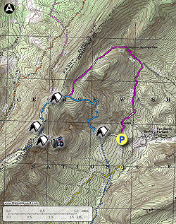
One of the least hiked circuits in the Great North Mountain trail system. This hike passes through Sulphur Springs Gap with small waterfalls and pools then gradually climbs the eastern flank of Paddy Mountain before joining the Tuscarora Trail and hike up to to White Rock Cliff and main Opa Overlook.
The descent along the Tuscarora trail is much steeper and you'll be
glad to hiked this counterclockwise. Also get views through the trees of
the valley below and White Rock Cliff and Tea Mountain.
If you're considering doing this as a backpack there are several great campsites close to the Opa Overlook. The main campsite are has three fire rings and is more of a group site suitable for multiple tents. If this site is taken just a few yards before it on the opposite side of the trail is a small campsite that can accommodate a single tent. And if both of these are occupied there is a larger campsite that will take multiple tens right at the junction of the Tuscarora Trail and the White Rock Cliff Lookout Trail. The only reason the camping doesn't get a top rating of 5 is the overlook and ridge campsites do not have a water source and you will have to carry water in.
- Mile 0.0 - From the parking area on FR1725 pass around the closed gate. You'll notice an unmarked trail on your left next to a stream. This will be your return route. Continue walking along FR1725 for 1.4 miles. The walk along FR1725 although uneventful is pleasant enough as it is closed to forestry traffic for the majority of the year. This section of FR1725 is also part of the Sulphur Sprigs Trail.
- Mile 1.4 - Turn left off FR1725 onto the purple blazed Sulphur Springs Gap Trail as it follows a small stream. The lower sections of the trail can be very muddy as the drainage here is not good. As the gap narrows there are nice rock formations on either side and several small pools and waterfalls. Cross the stream to the right bank for a short distance than cross the stream again for the second and last time where it now climbs a small ravine on the left. You will also see blue diamond markers on the trail as well as the purple blazes. As you climb higher pass through an area of pine and Mountain Laurel before the trail levels out then ends at the intersection of the blue blazed Tuscarora Trail.
- Mile 3.0 - Continue straight on the blue blazed Tuscarora Trail as it gently climbs towards the ridge. The trail becomes more grass covered then immediately before reaching the intersection of the Old Mail Path there is a campsite on the right side of the trail.
- Mile 3.4 - Turn left uphill remaining on the blue blazed Tuscarora Trail. On this section you will also see green tree markings placed there for a deer study. The Tuscarora trail becomes steeper along the ridge, then just before arriving at the White Rock Cliff Overlook Trail pass a large campsite on the right in front of a large rock formation.
- Mile 3.9 - Turn left onto the white blazed White Rock Cliff Overlook Trail and follow it for 0.2 miles to the best campsite of the hike on the right side of the trail. This camping area has three fire rings and room for multiple tents. On the off chance this entire area is full there is another small campsite on the opposite side of the trail just before you arrived here. Continue on the trail for a short distance where the trail climbs a short rocky section. At the top of the rocky area stay left and pass through several small boulders.
- Mile 4.2 - Arrive at White Rock Cliff and the Opa Overlook. There are several other viewpoints with rock outcrops to the left. From the overlook there are views east through Sheffer Gap towards the Massanutten Range and Shenandoah National Park, and to the south towards Harrisonburg VA. Return back to the intersection with the Tuscarora Trail.
- Mile 4.5 - Turn right downhill on the blue blazed Tuscarora Trail back towards the intersection with the Old Mail Pail.
- Mile 5.0 - Turn right retracing you route to the intersection where the Sulphur Springs Trail continues straight and the Tuscarora Trail turns right downhill.
- Mile 5.4 - Turn right downhill on the blue blazed Tuscarora Trail where is becomes steep in sections. There are views through the trees of the valley and in a couple of spots you can get a glimpse of White Rock Cliff. The trail will slowly become less steep and cross the stream a couple of times. Before the trail crosses a second larger stream the unblazed parking area connector trail will be on the left.
- Mile 6.1 - Turn left on the unblazed parking area connector trail and it a short distance pass a small campsite that has its fire ring almost in the trail. The connector trail can also be very boggy. Follow the trail along the left back of a stream back to the parking area on FR1725.
- Mile 6.5 - Arrive back at the parking area on FR1725.