The Sugar Hill Fire Tower Hike at Sugar Hill State Forest near Tyrone, New York is an easy 0.7-mile out-and-back hike that leads to an old fire tower.
Hike
This hike begins along the south side of Tower Hill Road, at the parking coordinates provided, and follows the dirt service road that leads up to the top of Sugar Hill. This service road is closed-off to the general public for driving, but you can hike, walk, and ride your horse along the dirt path as it makes its way up to the old fire tower.
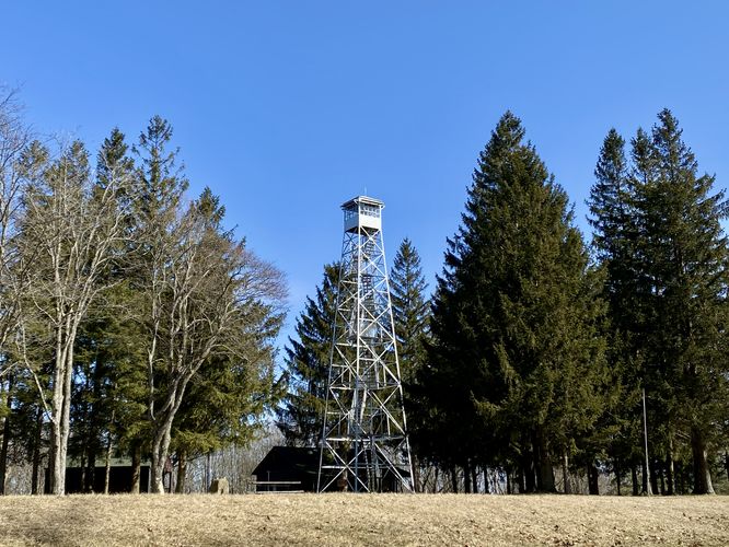
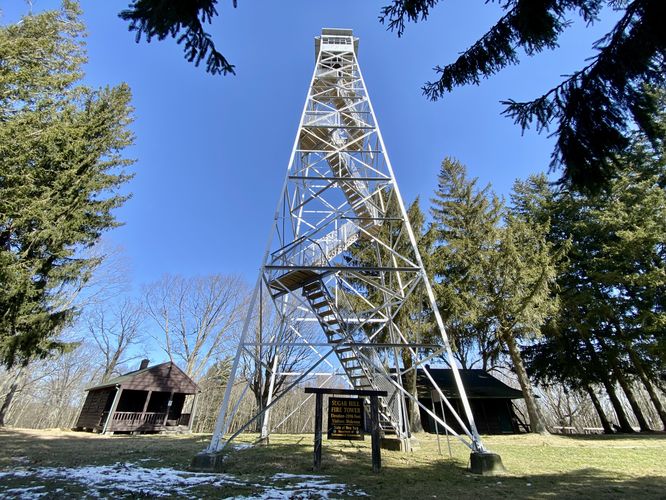
Soon, hikers will find themselves at the top of Sugar Hill as the road begins to curve around to reach campsites and more at the top. As the dirt road curves around, it exposes the Sugar Hill Fire Tower which, as of February 2024, is tucked away within a grove of evergreen trees. The top of the tower sits almost inline with the tops of the trees. During the Winter, the fire tower's staircases are closed-off to the public, but during warm months when there's no snow or ice, the fire tower can be climbed - at your own risk - with no more than 6 people on the tower at any given time. From the top of the fire tower, hikers can find views of Seneca Lake and the surrounding area; however, during our Winter visit, we missed out on the views.
After exploring the Sugar Hill Fire Tower, hikers can choose to venture further into the Sugar Hill State Forest, like this Sugar Hill Pond and Twin Lean-Tos Hike or hike back down the road and back to parking for a short 0.7-mile out-and-back adventure.
Parking
Hikers will find the closest parking lot located on the south side of Tower Hill Road near Tyrone, NY at the coordinates provided. The lot is large enough to fit a couple dozen vehicles at most. Note that the road that leads up to the fire tower is closed to the general public for vehicles and exists only as a foot path.
Camping
Note that the top of Sugar Hill provides several dozen campsites that line the southern forest boundary. These campsites appear to be first-come first-serve, have picnic tables, and more. Please follow all state forest rules and regulations if camping.
Restrooms
During warmer months, there's a restroom facility near the fire tower at the top of Sugar Hill.
Views
During warm months, when the fire tower stairs are open to the public, you can climb to the top of the Sugar Hill Fire Tower to get views of the surrounding area, including views of Seneca Lake.
Hike
This hike begins along the south side of Tower Hill Road, at the parking coordinates provided, and follows the dirt service road that leads up to the top of Sugar Hill. This service road is closed-off to the general public for driving, but you can hike, walk, and ride your horse along the dirt path as it makes its way up to the old fire tower.
Soon, hikers will find themselves at the top of Sugar Hill as the road begins to curve around to reach campsites and more at the top. As the dirt road curves around, it exposes the Sugar Hill Fire Tower which, as of February 2024, is tucked away within a grove of evergreen trees. The top of the tower sits almost inline with the tops of the trees. During the Winter, the fire tower's staircases are closed-off to the public, but during warm months when there's no snow or ice, the fire tower can be climbed - at your own risk - with no more than 6 people on the tower at any given time. From the top of the fire tower, hikers can find views of Seneca Lake and the surrounding area; however, during our Winter visit, we missed out on the views.
After exploring the Sugar Hill Fire Tower, hikers can choose to venture further into the Sugar Hill State Forest, like this Sugar Hill Pond and Twin Lean-Tos Hike or hike back down the road and back to parking for a short 0.7-mile out-and-back adventure.
Parking
Hikers will find the closest parking lot located on the south side of Tower Hill Road near Tyrone, NY at the coordinates provided. The lot is large enough to fit a couple dozen vehicles at most. Note that the road that leads up to the fire tower is closed to the general public for vehicles and exists only as a foot path.
Camping
Note that the top of Sugar Hill provides several dozen campsites that line the southern forest boundary. These campsites appear to be first-come first-serve, have picnic tables, and more. Please follow all state forest rules and regulations if camping.
Restrooms
During warmer months, there's a restroom facility near the fire tower at the top of Sugar Hill.
Views
During warm months, when the fire tower stairs are open to the public, you can climb to the top of the Sugar Hill Fire Tower to get views of the surrounding area, including views of Seneca Lake.