Loading...

🎉 Find content tailored to you in the For You tab! Learn More.

Strickler Knob Hike

Some of the best vistas in the mid-Atlantic. The Strickler Knob Trail is a challenging rock hopping/scramble with beautiful views of New Market Gap, the Luray Valley, and a 360 degree picture perfect panorama from the Strickler Knob summit. This is a challenging hike with a great little rock scramble on the ridge. Camp at any of the ridge campsites and enjoy great sunsets and sunrises over the Shenandoah Valley, however be sure to carry up water as there are no springs along the ridge.
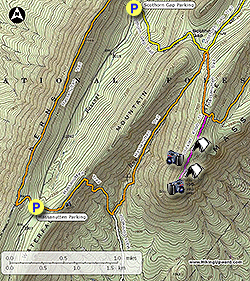
  • For the longer more challenging 8.6 mile/2,140ft gain hike park at the Massanutten trailhead.
  • Mile 0.0 - The Scothorn Gap parking and trailhead has two campsites if you are car camping. Cross Passage Creek and pass around a closed gate. The yellow blazed Scothorn Gap Trail is steep and rocky. The trail utilizes a forestry access road for the first 1.1 miles before arriving at Scothorn Gap.

  • Mile 1.1 - There is a large clearing and campsite under the trees at Scothorn Gap. Continue along the trail passing a pond on the left before reaching the intersection of the orange blazed Massanutten Trail.

  • Mile 1.4 - The yellow blazed Scothorn Gap Trail turns left here, with the orange blazed Massanutten Trail coming in from the right then turning uphill. Stay straight on the orange blazed Massanutten Trail, then arriving at the ridge and intersection of the pink blazed Strickler Knob trail on the right in another 0.6 miles.

  • Mile 2.0 - Now the fun starts. Firstly, thank you to the trail builders! This used to be a formidable bushwhack. The Strickler Knob trail is marked with pink blazes on the rocks, but may not be there as they have previously been removed by the Forestry Service. The trail will also appear to end in several places, but keep heading along the ridge and you'll pick the trail back up. After 0.3 miles pass a rock outcrop and view to the west and north across from a campsite. From this vista, continue on the trail rock hopping for another 0.4 miles to another opening, and beautiful vista to the southwest.

  • Mile 2.5 - Intersection with the blue blazed overlook trail. Follow the blue trail down to the east. The trail is hard to follow in places, and there is a nice overlook to the south shortly before arriving at one of the prettiest view campsites in western Virginia. There are views of the town of Luray and South Fork of the Shenandoah River. Return back to the intersection with the pink blazed Strickler Knob Trail.

  • Mile 2.7 - From this point the rock hopping and bouldering becomes more intense. Shortly pass another campsite with views east, then the first obstacle is a 12ft climb over a small rock wall. Just before the the main summit pass through a group of three boulders. This is not the summit stack! Once through the crack continue to follow the blazes, pass a small overhang, and climb a 6ft ledge.

  • Mile 2.9 - The main summit is accessed through a rock crack on the left. Continue for another 30ft to the southern summit overlook. Climbing to the main summit provides a 360 degree view of the Luray Valley and New Market Gap. To return retrace your route.

  • Mile 5.4 - Arrive back at the Scothorn Gap parking area.

Explore 105 trails near New Market, VA

Know Before You Go

  • Strickler Knob Trail offers challenging rock scrambles and stunning panoramic views of the Luray Valley and New Market Gap.
  • The trail is not always well-marked, requiring hikers to pay close attention to pink blazes and navigate rocky terrain.
  • Camping is available along the ridge, but hikers must carry their own water.
Interactive topographic map for Strickler Knob Hike located in New Market, VA. Click the "View Map" button to load GPS coordinates and trail markers.
Get directions
Distance
5.4 mi
Difficulty
Hard
Type
Out-and-Back
Est. Time
2.7 hrs
Elev. Gain
1,056'
Rating
4.3
Added
February 17, 2025
Updated
April 05, 2025

Weather Forecast

Overnight
Low 23°F
Cloudy
Tuesday
High 42°F
Mostly Cloudy then Chance Light Snow
Tuesday Night
Low 21°F
Chance Light Snow
Wednesday
High 33°F
Partly Sunny
Wednesday Night
Low 12°F
Mostly Cloudy
Thursday
High 31°F
Sunny
Thursday Night
Low 14°F
Partly Cloudy
Friday
High 39°F
Chance Light Snow
Friday Night
Low 17°F
Slight Chance Light Snow then Partly Cloudy
Saturday
High 29°F
Sunny
Saturday Night
Low 9°F
Mostly Clear
Sunday
High 29°F
Mostly Sunny
Sunday Night
Low 8°F
Mostly Clear
Monday
High 31°F
Mostly Sunny
Loading...
Total Change
846'
Ascent
1,056'
Descent
1,053'
Loading...

Download the GPX Data for Offline Use

Supporters get exclusive access to download trail routes to the MyHikes app for offline use. Stay prepared on your adventure, even without an internet connection! Become a Supporter today to unlock this feature and hike with confidence.

Download Strickler Knob Hike GPX Data to the MyHikes Mobile App

Features

Vista / Lookout Point
Dogs
Mountain Summit
Camping

Points of interest

  1. Parking

    38.691206, -78.580008
  2. Main Trailhead

    38.690727, -78.580227

Safety information

For your own safety: plan ahead, let someone know where you'll be, and hike at your own risk.

Hazards

Snakes (Rattlesnakes, Copperheads, others)
Poison Ivy or Poison Oak
Rockfalls, Ledges, or Scrambles

Availability

All seasons

Surface type

Dirt

Trip Reports (Reviews)

Rated 4.32 out of 5 based on 164 ratings.

Ready to help fellow hikers? Add a trip report to share your experience and provide valuable insights for other hikers!

By: Thi
5.4 miles / 8.7 km
October 05, 2019
It is a quiet and peaceful hike, not many people on the trail. The view is great and there are some parts that require rock scrambling, which makes the hike more fun.
Legacy Review
By: Meredith - 28 yr old runner
5.4 miles / 8.7 km
August 24, 2019
The weather was perfect and view from Strickler Knob was even better than McAfees! I was surprised at how few others were on top on a 75deg Saturday but I didn’t mind! Do not start the hike from the suggested parking area... unless you absolutely hate yourself! And if you’re stubborn like myself, at least bring trekking poles or find TWO good hiking sticks on your way to help with the one mile 45 deg incline. We had a total of 9.5 miles when we finished. Take the five mile route from Scothorn Gap, or hike in this route then return to Scothorn Gap trailhead and walk the road back.
Legacy Review
By: Fabrice
5.4 miles / 8.7 km
August 11, 2019
Decided to start the hike from the Massanutten Connector Trail parking because the route suggested by Hiking Upward is too steep on the return... I thought the total hike would end up being 9 miles but it turns out to be 11 miles total. Anyway it was a great day. In the 80s but dry so the heat didn't bother me much. the rock scramble at the top reminded of Old Rag a bit. But the crowds weren't there which was very nice. I saw four other people that day. I like the fact that you can access Strickler Knob from different starting points. you can make it the length you want.
Legacy Review
No community routes found. To add your own hike as a Community Route for this Trail guide, leave a Trip Report with an attached GPX file.

Popular categories

Scenic mountain view representing vista trails
Vista trails
Scenic gorge of cascades representing waterfall trails
Waterfall hikes
Rugged mountain terrain representing summit trails
Summit trails
Scenic mountain view representing dog-friendly trails
Dog-friendly
Scenic campsite with a view representing camping trails
Camping trails
Appalachian Trail logo representing A.T. hikes
A.T. hikes

You May Also Like

25 Best Day Hikes in North Carolina - Discover the top 25 best day hikes in North Carolina, from breathtaking waterfalls to mountain peaks. Explore hidden gems, scenic views, and trails suitable for all skill levels, perfect for your next outdoor adventure.
Explore

25 Best Day Hikes in North Carolina

Discover the top 25 best day hikes in North Carolina, from breathtaking waterfalls to mountain peaks. Explore hidden gems, scenic views, and trails suitable for all skill levels, perfect for your next outdoor adventure.

Read
🍪 We use cookies to learn about site usage and to serve map tiles. You may block cookies manually in the browser. By continuing you agree. Learn more