Loading...

🔥 End of Summer sale! 50% off on Supporter Accounts — now through September 1st. Learn More.

Stony Man Mountain Loop Hike

Directions
Map
Pictures
Send to App
Distance:
3.4 Miles / 5.5 km
Type:
Loop
Difficulty:
Easy
Time to Hike:
1 hour, ~42 minutes
Features:
Surface Type:
Dirt
Park:
Shenandoah National Park
Town:
Valleyburgh, Virginia
Directions:
38.593401, -78.376186
Added:
April 06, 2025
Updated:
April 06, 2025
Guide by:
Copy Trail Link Hiking this trail? Send a friend or family member a link to this trail guide for your own safety. Hike at your own risk (disclaimer)
Loading...
Loading...
677'

Total Change
664'

Ascent
675'

Descent

Download the Trail Route for Offline Use

Supporters get exclusive access to download trail routes to the MyHikes app for offline use. Stay prepared on your adventure, even without an internet connection! Become a Supporter today to unlock this feature and hike with confidence.

Send to App

Stony Man Mountain Loop Hike

This is a short and pleasant hike, and has some of the best vistas in the Shenandoah National Park. Little Stony Man, just below the main peak, has a popular rock wall with local climbers. Make sure to pick a haze free day, because you don't want to miss all the views along the the ridge!

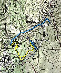
Start the hike on the left of the parking area at the trail junction. Turn right on the on the yellow blazed Stony Man Trail for 0.5 miles to the intersection of the Horse Trail.

Turn left uphill on the Horse Trail for 0.5 miles and come to the first of the Shenandoah Valley overlooks. Continue up the trail for another 50 yards to the junction of the the blue blazed trail, and horse rail. Turn left, and in 80 yards arrive at the main Stony Man Mountain overlook.

Return back, passing the trail you turned off in 80 yards, where the blue blazed trail splits. Stay left, and in 0.4 miles the trails rejoin. Continue downhill for another 0.1 miles to the the four way intersection of the white blazed Appalachian Trail.

Turn left on the white blazed trail for 0.7 miles to the Little Stony Man overlook. As you continue downward make several switchbacks before reaching the left turn for the blue blazed Passamaquoddy Trail. The Passamaquoddy Trail turnoff is easy to miss. Look for a concrete post marker and a double white blazed tree marking the junction.

The Passamaquoddy Trail will pass a lower vista at the base of the Little Stony Man Mountain cliff face. Continue around the mountain for 1.0 miles to the junction of Furnace Spring Road. Turn left uphill for 20 yards, then make a sharp turn to the left again onto the yellow blazed trail. Follow the yellow blazed trail as it winds uphill, arriving back at the Stony Man Mountain parking area in 0.5 miles.

Explore 94 trails near Valleyburgh, VA
  1. Parking

    38.593401, -78.376186
  2. Main Trailhead

    38.593401, -78.376186
No community routes found. To add your own hike as a Community Route for this Trail guide, leave a Trip Report with an attached GPX file.

Hazards

Ticks - Lyme Disease More Info (CDC)
Snakes

Seasons

All

Trip Reports (Reviews)

Rated 3.89 out of 5 based on 53 ratings.
By: Brian Schwarz
3.4 miles / 5.5 km
October 24, 2019
The hike described here is perfect. I was worried that hiking at the height of the October I'd be overwhelmed by novice hikers along the entire trail route. And, well, the summit of Stony Man was overrun. However, for 90 percent of the hike I was all by myself and had a wonderful, peaceful hike. The Passamaquoddy Trail section is my favorite. There is an amazing view here, too. In fact, there are three stunning rock outcrops along this hike! It felt so isolated at times, and it reminded me of hikes I've taken out west, particularly in the Sandia Mountains outside of Albuquerque. Follow me on IG at "brianopolis" to see some pics!
Legacy Review
By: Diego
3.4 miles / 5.5 km
September 06, 2019
Was going to do this hike today, but ended up not because I had a dog with me, and this trail doesn't allow dogs. Hadn't seen anyone mention that before, so figured I'd let people know to NOT bring your dog on this trail.
Legacy Review
By: TAG
3.4 miles / 5.5 km
December 24, 2018
We were blown away by how beautiful this hike was. It was bitter cold and windy on December 24th but the trail was coated in snow and the leaves were gone which made for a magical snowy scene. The early vista was beautiful. There are two paths out to separate peaks here which are close enough that we photographed each other from opposite peaks. Amazing photos. The short ridge area was a beautiful lookout in itself and we even saw ropes attached there where people were climbing up the cliff side. Further down passamaquaddy trail was yet another beautiful vista. We loved every minute of this hike and look forward to coming back in different seasons to enjoy different views.
Legacy Review

Weather Forecast

In Valleyburgh, VA

Explore Hiking Trails

You May Also Like

New York's Best Waterfalls - Whether you're planning a day hike, roadside stop, or a leisurely short walk, this guide provides hikers, travelers, and locals alike with 63 different locations to over 100 scenic waterfalls to help plan your next adventure!
Explore

New York's Best Waterfalls

Whether you're planning a day hike, roadside stop, or a leisurely short walk, this guide provides hikers, travelers, and locals alike with 63 different locations to over 100 scenic waterfalls to help plan your next adventure!

Read
25 Best Day Hikes in North Carolina - Discover the top 25 best day hikes in North Carolina, from breathtaking waterfalls to mountain peaks. Explore hidden gems, scenic views, and trails suitable for all skill levels, perfect for your next outdoor adventure.
Explore

25 Best Day Hikes in North Carolina

Discover the top 25 best day hikes in North Carolina, from breathtaking waterfalls to mountain peaks. Explore hidden gems, scenic views, and trails suitable for all skill levels, perfect for your next outdoor adventure.

Read

Before you boogie...

Find our trail guides useful? Consider becoming a Supporter to unlock perks!

MyHikes is an indie platform that makes exploring public trails easier for everyone. The platform has no investors, no ads, and is owned and operated by one person, Dave Miller. Dave has personally mapped and written over 1,800 trail guides on MyHikes for the public to explore. MyHikes has helped millions outdoor enthusiasts plan their next adventure.

But it takes a lot of time 🕦, money 💰, work, and espresso shots ☕ to run MyHikes, including hiking , mapping , writing , and publishing new trails with high-quality (accurate) information... along with software engineering (coding) the platform like building new features, website and mobile app development (iOS and Android), site maintainance . and much much more.

Supporters unlock website and mobile app perks with an annual one-time payment of $25 (you renew) 😎👍. Or you can simply make a Donation of your choice. Otherwise, you can support us by telling your friends about MyHikes - both quick and free 🎉

Admin user profile picture

Dave Miller
MyHikes Founder