The Stony Fork Waterfalls Hike via MST at Tioga State Forest near Morris, Pennsylvania is a difficult 4.4-mile out-and-back trail that features three large waterfalls - unofficially named Champagne Falls (25-feet tall), Tumbling Falls (12-feet tall), and Moss Rock Falls (18-feet tall) - that cascade down an unnamed tributary that feeds Stony Fork creek. The hike also features a peaceful walk along the western banks of Stony Fork creek with opportunities for trout fishing.
Trails
This hike follows the Mid State Trail (MST). Also check out our Big Falls and Little Falls hiking guide for another hike in the same area.
Hike Description
This trek begins along Clay Mine Road and heads northwest along a mountain laurel-lined trail. Around mile 0.1, hikers will reach a trail registry box where you can check-in. Shortly after, the trail meanders its way through a large outcropping of boulders - approximately 10 to 15-feet tall. This section of trail passes a large rock ledge as well - an area that was likely used as a quarry. Some of these boulders are large enough for bouldering. After passing the boulder field, the trail will take a right-hand turn and head toward the unnamed tributary creek that feeds into Stony Fork creek. This unnamed tributary is locally referred to as "Moss Run", as most of the creek is filled with moss.
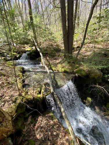
Once hikers reach the creek, the trail follows a very scenic, but rocky trail as it descends the hollow - passing countless small cascades and waterfalls in the creek from miles 0.6 to mile 1. Most of the way, hikers will be passing small waterfalls between 2 and 4-feet tall before reaching the best section of the hike - the back-to-back large waterfall grove. Hikers should note that the rocky terrain is not easy to walk on and wears you down faster than anticipated, which makes this hike more difficult.
Large Waterfalls - Mile 1 to Mile 1.5
Between miles 1 and 1.5, hikers will be passing three large waterfalls. The top of Champagne Falls can be found around Mile 1 and the last waterfall - Moss Rock Falls, can be found around mile 1.5. None of these waterfalls have official names on any maps, so I've given them each my own names - which others can take or leave, but they help identify each of them on the trail map. Hikers should note that the trail always follows a switchback to the base or near the base of each large waterfall.
Champagne Falls
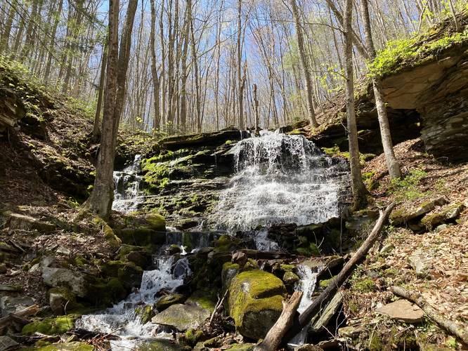
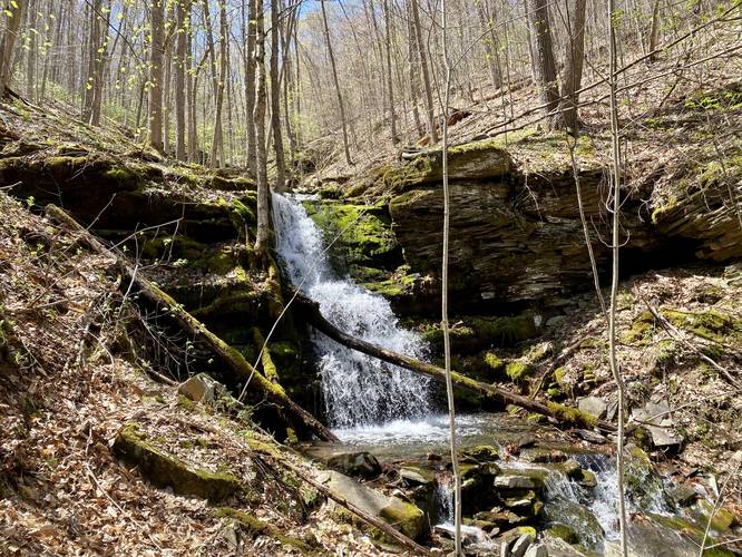
The first large waterfall, which is the largest of the three main waterfalls, is approximately 25-feet tall, which I've named Champagne Falls. This waterfall has a secondary cascade that spills down the left-hand side of the rock ledge, and with the sparkling water in the sun, it reminded me of a wedding champagne fall - hence the name. Hikers can reach the base of this waterfall by carefully hiking upstream, crossing the creek several times, but it's not far off-trail and worth it for a better view.
Hikers should note there are two creek crossings between the 1st large waterfall - Champagne Falls, and the second waterfall - Tumbling Falls. Neither of them are very difficult or deep.
Tumbling Falls
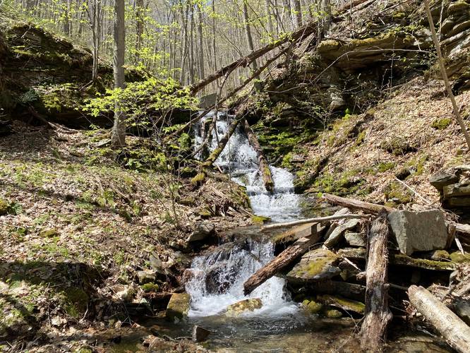
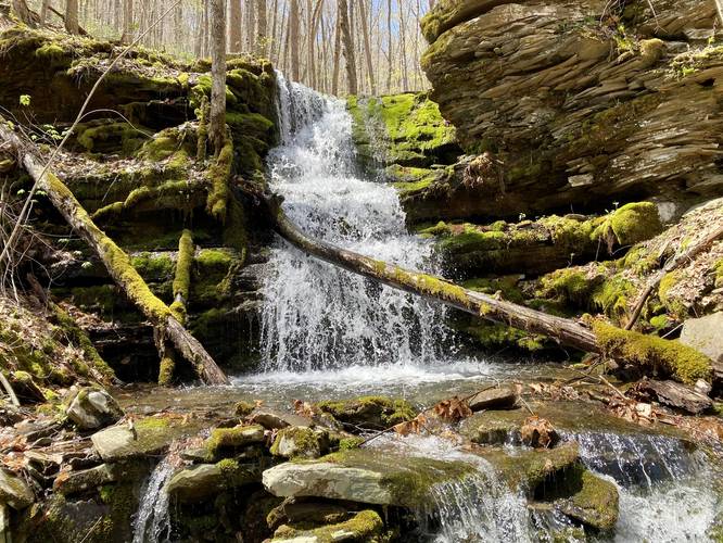
The second waterfall, which seems to be the smallest of the three main falls, is approximately 12-feet tall and nicknamed Tumbling Falls. This waterfall cascades down a rocky ledge and is located about 0.2-miles downstream from Champagne Falls after the creek crossings. This smaller waterfall is still a welcomed sight along the trail and is still significantly larger than the smaller cascades located above Champagne Falls.
Moss Rock Falls
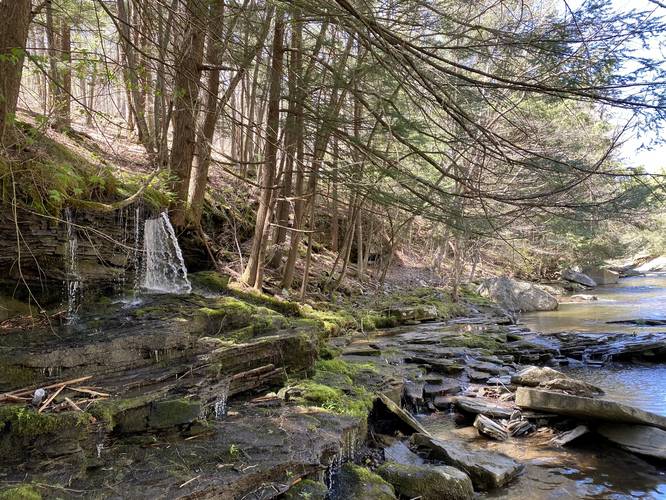
After visiting the second waterfall, the last large waterfall - Moss Rock Falls - is located a stones-throw downstream. Moss Rock Falls cascades down a large mossy rock ledge - hence the name - and is approximately 18-feet tall. This waterfall is the most-easily accessible waterfall located just off-trail.
Stony Fork Creek Hike
After visiting the last large waterfall - Moss Rock Falls - the trail will turn to the right as it starts to follow alongside Stony Fork creek. Here, the trail becomes flatter, less rocky, and easier to follow until it starts to head back uphill - right around where this data ends. We ended up tracking the MST south along Stony Fork creek for about 0.7-miles before turning back due to a lack of trekking poles for the steep and rocky hillside climbs on the way to Big Falls and Little Falls - officially-named waterfalls located in Stony Fork creek downstream. Regardless of where we turned back, the trail along Stony Fork is beautiful and gives hikers a chance to try their hand at some native trout or brook trout fishing as the creek has numerous large pools for fishing.
Difficulty
We found this hike a lot more challenging than expected due to the rocky terrain and loose footing with debris and leaves littering the trail for 50% of the hike - hence "hard" difficulty. The terrain wears you down faster than you anticipate as you have to constantly check your footing on each step. On top of that, the entire climb back up the hollow - passing the waterfalls - is just as annoying terrain-wise, but includes the elevation gain. Also note that there are several sections of trail along Stony Fork where the hillside becomes extremely steep and the trail becomes extremely narrow.
Parking
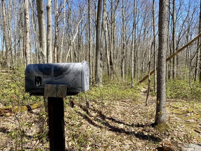
Hikers will find a small parking lot near the coordinates provided. It's located about 100-feet west of the trailhead for the Mid State Trail (MST) and can hold about 5 vehicles.
Pets
Dogs are allowed and should be leashed.
Blaze Color
This trail follows the orange blazes of the Mid State Trail (MST).
Camping and Backpacking
Backpackers are welcomed along the Mid State Trail; however, this section did not pass any predefined campsites. The state forest, game lands, and the Mid State Trail guide both ask backpackers to refrain from camping near or along Stony Fork to keep this area of the woods pristine. Please follow all state forest rules and regulations for primitive / dispersed / backcountry camping.
Trails
This hike follows the Mid State Trail (MST). Also check out our Big Falls and Little Falls hiking guide for another hike in the same area.
Hike Description
This trek begins along Clay Mine Road and heads northwest along a mountain laurel-lined trail. Around mile 0.1, hikers will reach a trail registry box where you can check-in. Shortly after, the trail meanders its way through a large outcropping of boulders - approximately 10 to 15-feet tall. This section of trail passes a large rock ledge as well - an area that was likely used as a quarry. Some of these boulders are large enough for bouldering. After passing the boulder field, the trail will take a right-hand turn and head toward the unnamed tributary creek that feeds into Stony Fork creek. This unnamed tributary is locally referred to as "Moss Run", as most of the creek is filled with moss.
Once hikers reach the creek, the trail follows a very scenic, but rocky trail as it descends the hollow - passing countless small cascades and waterfalls in the creek from miles 0.6 to mile 1. Most of the way, hikers will be passing small waterfalls between 2 and 4-feet tall before reaching the best section of the hike - the back-to-back large waterfall grove. Hikers should note that the rocky terrain is not easy to walk on and wears you down faster than anticipated, which makes this hike more difficult.
Large Waterfalls - Mile 1 to Mile 1.5
Between miles 1 and 1.5, hikers will be passing three large waterfalls. The top of Champagne Falls can be found around Mile 1 and the last waterfall - Moss Rock Falls, can be found around mile 1.5. None of these waterfalls have official names on any maps, so I've given them each my own names - which others can take or leave, but they help identify each of them on the trail map. Hikers should note that the trail always follows a switchback to the base or near the base of each large waterfall.
Champagne Falls
The first large waterfall, which is the largest of the three main waterfalls, is approximately 25-feet tall, which I've named Champagne Falls. This waterfall has a secondary cascade that spills down the left-hand side of the rock ledge, and with the sparkling water in the sun, it reminded me of a wedding champagne fall - hence the name. Hikers can reach the base of this waterfall by carefully hiking upstream, crossing the creek several times, but it's not far off-trail and worth it for a better view.
Hikers should note there are two creek crossings between the 1st large waterfall - Champagne Falls, and the second waterfall - Tumbling Falls. Neither of them are very difficult or deep.
Tumbling Falls
The second waterfall, which seems to be the smallest of the three main falls, is approximately 12-feet tall and nicknamed Tumbling Falls. This waterfall cascades down a rocky ledge and is located about 0.2-miles downstream from Champagne Falls after the creek crossings. This smaller waterfall is still a welcomed sight along the trail and is still significantly larger than the smaller cascades located above Champagne Falls.
Moss Rock Falls
After visiting the second waterfall, the last large waterfall - Moss Rock Falls - is located a stones-throw downstream. Moss Rock Falls cascades down a large mossy rock ledge - hence the name - and is approximately 18-feet tall. This waterfall is the most-easily accessible waterfall located just off-trail.
Stony Fork Creek Hike
After visiting the last large waterfall - Moss Rock Falls - the trail will turn to the right as it starts to follow alongside Stony Fork creek. Here, the trail becomes flatter, less rocky, and easier to follow until it starts to head back uphill - right around where this data ends. We ended up tracking the MST south along Stony Fork creek for about 0.7-miles before turning back due to a lack of trekking poles for the steep and rocky hillside climbs on the way to Big Falls and Little Falls - officially-named waterfalls located in Stony Fork creek downstream. Regardless of where we turned back, the trail along Stony Fork is beautiful and gives hikers a chance to try their hand at some native trout or brook trout fishing as the creek has numerous large pools for fishing.
Difficulty
We found this hike a lot more challenging than expected due to the rocky terrain and loose footing with debris and leaves littering the trail for 50% of the hike - hence "hard" difficulty. The terrain wears you down faster than you anticipate as you have to constantly check your footing on each step. On top of that, the entire climb back up the hollow - passing the waterfalls - is just as annoying terrain-wise, but includes the elevation gain. Also note that there are several sections of trail along Stony Fork where the hillside becomes extremely steep and the trail becomes extremely narrow.
Parking
Hikers will find a small parking lot near the coordinates provided. It's located about 100-feet west of the trailhead for the Mid State Trail (MST) and can hold about 5 vehicles.
Pets
Dogs are allowed and should be leashed.
Blaze Color
This trail follows the orange blazes of the Mid State Trail (MST).
Camping and Backpacking
Backpackers are welcomed along the Mid State Trail; however, this section did not pass any predefined campsites. The state forest, game lands, and the Mid State Trail guide both ask backpackers to refrain from camping near or along Stony Fork to keep this area of the woods pristine. Please follow all state forest rules and regulations for primitive / dispersed / backcountry camping.