The Big Falls and Little Falls hike at Tioga State Forest near Morris, Pennsylvania is an easy 2.4-mile out-and-back trail that leads to two waterfalls with beautiful turquoise swimming holes within Stony Fork creek, named Big Falls and Little Falls. This hike also includes two unnamed waterfalls as well, with four to see in total.
Swimming Hole & Popularity
For folks looking to access the swimming hole without spending time hiking, please check out our Big Falls Swimming Hole guide. Note that this is a popular swimming hole during the Summer months. If jumping in, do not dive to reduce any chance of injury. Swim at your own risk.
Trails
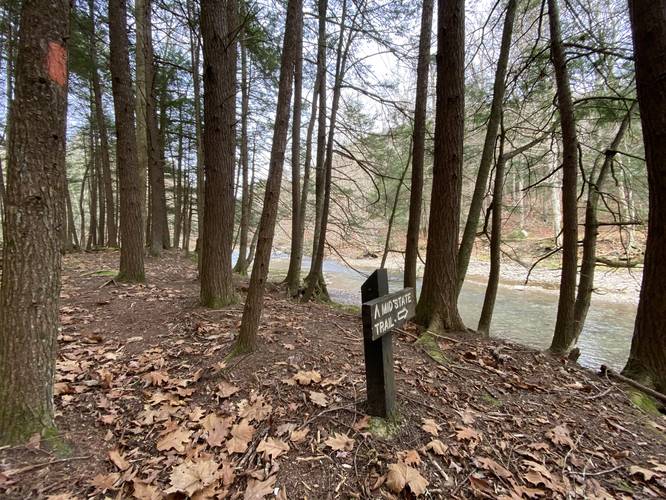
This hike follows two named trails in order: Beer Can Trail (yellow blazes), Mid State Trail / MST (orange blazes).
Hike Description
This hike begins along Clay Mine Rd at Tioga State Forest near the parking coordinates provided and follows the Beer Can Trail (yellow blazes) for about 0.35-miles before the trail terminates at the junction with the Mid State Trail (orange blazes). At the Mid State Trail junction (also the Stony Fork creek crossing for the MST), hikers will continue north along the MST to make their way toward Big Falls and Little Falls.
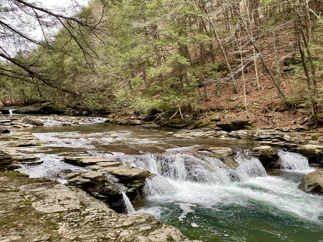
Short Falls - mile 0.55
Around mile 0.55, hikers will find a very short, but wide waterfall (approx. 1.5-feet tall by 30+ feet wide) that cascades down Stony Fork creek. I've nicknamed this waterfall "Short Falls". While short, this waterfall is a nice scenic stop along the way.
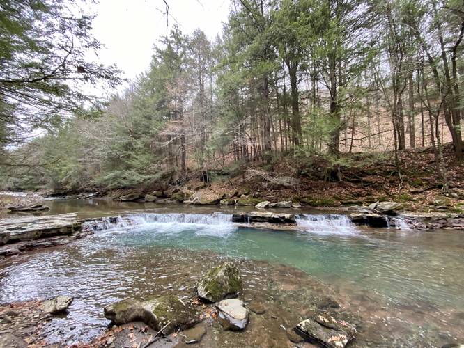
Waterfall Two - mile 0.6
After stopping at Short Falls, hikers will find a taller waterfall in Stony Fork creek - approximately 2 to 3-feet tall and about 15-feet wide. When looking upstream, hikers will notice Big Falls in the background.
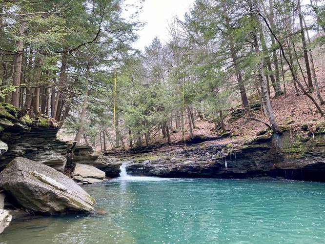
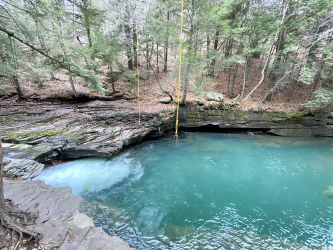
Big Falls & Swimming Hole - mile 0.66
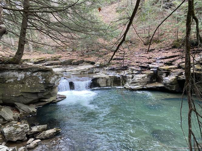
Finally, hikers will reach Big Falls and the beautiful turquoise deep swimming hole. Big Falls is approximately 6-feet tall and 3-feet wide most of the year, but after heavy rains, the waterfall widens to about 20-feet. While the waterfall itself is not very impressive, the swimming hole with the two rope swings (as of November 2021) are well worth the hike to visit. The water's turquoise color (which varies based on the water level and time of year) likely cannot be found in many places like it nearby, making this a hidden gem of a spot. Big Falls' swimming hole appears to be over 15-feet deep, if not deeper, making this the perfect spot for the rope swings. If jumping in, do not dive to reduce any chance of injury. This is a great spot for backpackers to cool off during their journey along the MST as well.
Hiking to Little Falls
The hike to Little Falls from Big Falls is about 0.4-miles long with a small hill in between. The northern side of this hill can be tricky to hike when its wet with fallen leaves as the elevation grade is very steep, but does not last very long. Otherwise, the hike is easy as it follows the orange blazes of the MST north, through a conifer forest, and out to Little Falls.
Little Falls - mile 1.1
Finally, hikers will reach Little Falls around mile 1.1, which cascades down Stony Fork creek at about 3-feet tall and ~15-feet wide when the water level is higher. During this visit, the waterfall was only about 6-feet wide. The swimming hole that Little Falls spills into is yet another beautiful turquoise pool, but it's a bit smaller than Big Falls (hence the name).
After visiting Little Falls, this recording follows the Mid State Trail a bit further as their trail map depicted Little Falls around the bend in Stony Fork - halfway between the next bend; however, it appears as though Little Falls actually sits closer to the bend in the creek than depicted on their map. We decided to turn around not too far after visiting Little Falls, making for a 2.4-mile out-and-back hike.
The hike back is identical, but opposite to the hike in. Enjoy the waterfalls on your way out!
Parking
Hikers will find parking at the coordinates provided along Clay Mine Rd; however, Clay Mine Rd and Stony Fork Rd do not technically connect except if the water is low enough and if your vehicle has enough clearance to cross Stony Fork creek. Do not attempt to drive across the creek if you do not have AWD, 4WD, and / or enough clearance since there's no cell phone service in the area. The best way to reach the parking lot is to drive along Clay Mine Rd only. This parking area and these roads are not accessible or maintained during winter months. Ice and snow usually show up in late November and ends around mid-April.
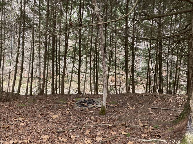
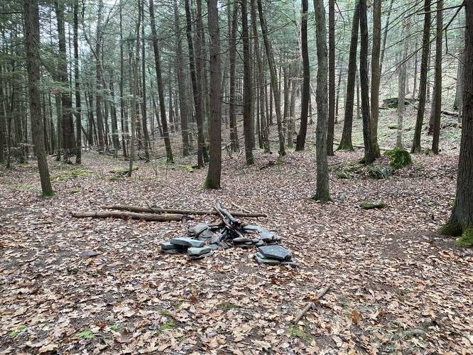
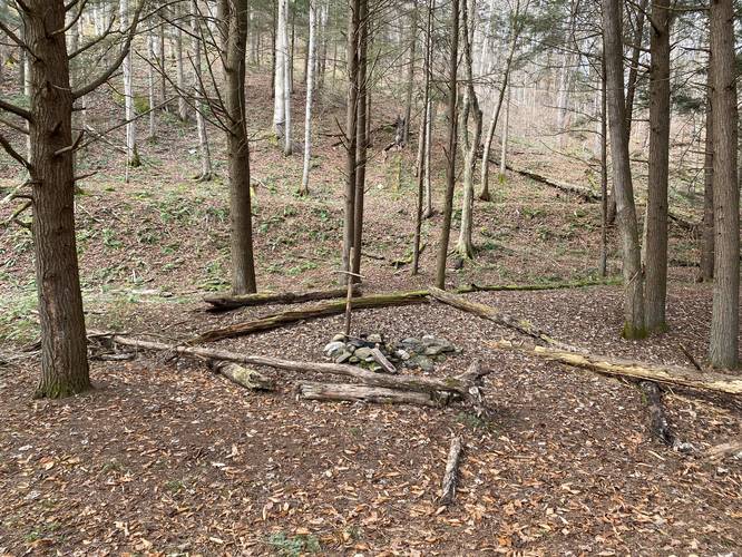
Camping
While there are campsites listed along this hike, it's best not to camp here, as the state forest asks backpackers to not camp along Stony Fork creek. By not camping along Stony Fork creek, we can all keep this beautiful gem of Tioga State Forest clean for future generations. Please follow all state forest rules and regulations when dispersed / primitive / backcountry camping.
Pets
Dogs are allowed if leashed and their waste should be carried out by the hiker.
Warnings
Rattlesnakes: during warmer months (end of April - early October) the Timber Rattlesnake may be found on the rocks along Stony Fork creek sunning or hunting. Watch out for rattlesnakes and keep your distance if you find one.
Steep cliffs: this trail follows some steep cliffs that sit along Stony Fork creek along with some steep hillsides. Trekking poles, or broken branches, are useful along this hike to keep your balance in certain areas. The trail can also become narrow along some of these steeper sections.
No cell service: there's no cell phone service available along this trail as of November 2021.
Swimming Hole & Popularity
For folks looking to access the swimming hole without spending time hiking, please check out our Big Falls Swimming Hole guide. Note that this is a popular swimming hole during the Summer months. If jumping in, do not dive to reduce any chance of injury. Swim at your own risk.
Trails
This hike follows two named trails in order: Beer Can Trail (yellow blazes), Mid State Trail / MST (orange blazes).
Hike Description
This hike begins along Clay Mine Rd at Tioga State Forest near the parking coordinates provided and follows the Beer Can Trail (yellow blazes) for about 0.35-miles before the trail terminates at the junction with the Mid State Trail (orange blazes). At the Mid State Trail junction (also the Stony Fork creek crossing for the MST), hikers will continue north along the MST to make their way toward Big Falls and Little Falls.
Short Falls - mile 0.55
Around mile 0.55, hikers will find a very short, but wide waterfall (approx. 1.5-feet tall by 30+ feet wide) that cascades down Stony Fork creek. I've nicknamed this waterfall "Short Falls". While short, this waterfall is a nice scenic stop along the way.
Waterfall Two - mile 0.6
After stopping at Short Falls, hikers will find a taller waterfall in Stony Fork creek - approximately 2 to 3-feet tall and about 15-feet wide. When looking upstream, hikers will notice Big Falls in the background.
Big Falls & Swimming Hole - mile 0.66
Finally, hikers will reach Big Falls and the beautiful turquoise deep swimming hole. Big Falls is approximately 6-feet tall and 3-feet wide most of the year, but after heavy rains, the waterfall widens to about 20-feet. While the waterfall itself is not very impressive, the swimming hole with the two rope swings (as of November 2021) are well worth the hike to visit. The water's turquoise color (which varies based on the water level and time of year) likely cannot be found in many places like it nearby, making this a hidden gem of a spot. Big Falls' swimming hole appears to be over 15-feet deep, if not deeper, making this the perfect spot for the rope swings. If jumping in, do not dive to reduce any chance of injury. This is a great spot for backpackers to cool off during their journey along the MST as well.
Hiking to Little Falls
The hike to Little Falls from Big Falls is about 0.4-miles long with a small hill in between. The northern side of this hill can be tricky to hike when its wet with fallen leaves as the elevation grade is very steep, but does not last very long. Otherwise, the hike is easy as it follows the orange blazes of the MST north, through a conifer forest, and out to Little Falls.
Little Falls - mile 1.1
Finally, hikers will reach Little Falls around mile 1.1, which cascades down Stony Fork creek at about 3-feet tall and ~15-feet wide when the water level is higher. During this visit, the waterfall was only about 6-feet wide. The swimming hole that Little Falls spills into is yet another beautiful turquoise pool, but it's a bit smaller than Big Falls (hence the name).
After visiting Little Falls, this recording follows the Mid State Trail a bit further as their trail map depicted Little Falls around the bend in Stony Fork - halfway between the next bend; however, it appears as though Little Falls actually sits closer to the bend in the creek than depicted on their map. We decided to turn around not too far after visiting Little Falls, making for a 2.4-mile out-and-back hike.
The hike back is identical, but opposite to the hike in. Enjoy the waterfalls on your way out!
Parking
Hikers will find parking at the coordinates provided along Clay Mine Rd; however, Clay Mine Rd and Stony Fork Rd do not technically connect except if the water is low enough and if your vehicle has enough clearance to cross Stony Fork creek. Do not attempt to drive across the creek if you do not have AWD, 4WD, and / or enough clearance since there's no cell phone service in the area. The best way to reach the parking lot is to drive along Clay Mine Rd only. This parking area and these roads are not accessible or maintained during winter months. Ice and snow usually show up in late November and ends around mid-April.
Camping
While there are campsites listed along this hike, it's best not to camp here, as the state forest asks backpackers to not camp along Stony Fork creek. By not camping along Stony Fork creek, we can all keep this beautiful gem of Tioga State Forest clean for future generations. Please follow all state forest rules and regulations when dispersed / primitive / backcountry camping.
Pets
Dogs are allowed if leashed and their waste should be carried out by the hiker.
Warnings
Rattlesnakes: during warmer months (end of April - early October) the Timber Rattlesnake may be found on the rocks along Stony Fork creek sunning or hunting. Watch out for rattlesnakes and keep your distance if you find one.
Steep cliffs: this trail follows some steep cliffs that sit along Stony Fork creek along with some steep hillsides. Trekking poles, or broken branches, are useful along this hike to keep your balance in certain areas. The trail can also become narrow along some of these steeper sections.
No cell service: there's no cell phone service available along this trail as of November 2021.