Loading...

๐ŸŽ† 50% off 4th of July sale on Supporter Accounts โ€” now through July 6! Learn More.

Stockbridge Falls

Directions
Map
Pictures
Send to App
Distance:
0.1 Miles / 0.2 km
Type:
Out-and-Back
Difficulty:
Easy
Time to Hike:
~5 minutes
Features:
Surface Type:
Dirt
Town:
Munnsville, New York
Directions:
42.951402, -75.604048
Added:
August 26, 2023
Updated:
August 30, 2023
Copy Trail Link Hiking this trail? Send a friend or family member a link to this trail guide for your own safety. Hike at your own risk (disclaimer)
Loading...
Loading...
10'

Total Change
12'

Ascent
12'

Descent

Download the Trail Route for Offline Use

Supporters get exclusive access to download trail routes to the MyHikes app for offline use. Stay prepared on your adventure, even without an internet connection! Become a Supporter today to unlock this feature and hike with confidence.

Send to App

Stockbridge Falls

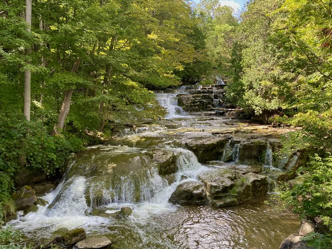
Stockbridge Falls in Munnsville, New York is an easy 0.1-mile out-and-back or simply a roadside stop to view the multi-tiered cascades of this ~30-foot tall scenic waterfall.

This is not necessarily a hike, but rather a quick roadside stop where visitors can view Stockbridge Falls from the road, which provides a stunning view of the ~30-foot tall and 200-foot long waterfall. Note that the GPS track provided does lead up an overgrown and skinny trail that leads to one of the middle cascades of Stockbridge Falls, which hikers can explore if they wish. The out-and-back walk is less than 0.1-miles, so the walking is negligible. There's a fence line further up the trail with posted signs, so stay off of the private property.

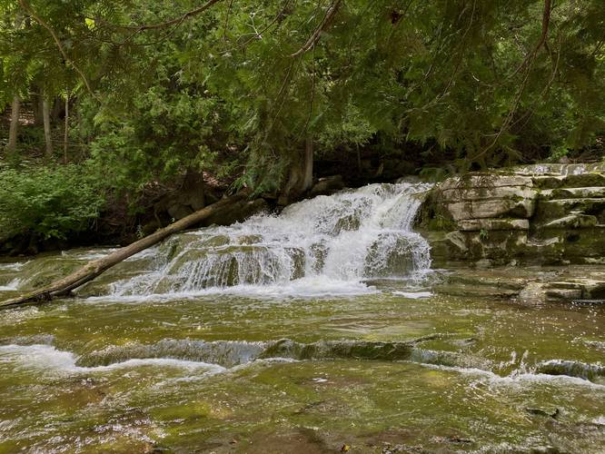
The best views of the waterfall is arguably from the road, but it's nice to walk around Oneida Creek's bedrock a bit when the water level is low enough. Before you leave, if you wish to explore one more waterfall via a bit of a ledge scramble, check out Lower Stockbridge Falls which sits just across the street.

Parking
Hikers will find parking at the coordinates provided on the west side of Falls Road in Munnsville, NY.

Pets
Dogs are allowed only if leashed and should be cleaned up after.
Explore 9 trails near Munnsville, NY
  1. Parking

    42.951402, -75.604048
  2. Main Trailhead

    42.95139, -75.604088
  3. Middle cascade of Stockbridge Falls

    42.951377, -75.604386
    Middle cascade of Stockbridge Falls
  4. Stockbridge Falls, ~30-feet tall multi-tiered

    42.951244, -75.604156
    Stockbridge Falls, ~30-feet tall multi-tiered
No community routes found. To add your own hike as a Community Route for this Trail guide, leave a Trip Report with an attached GPX file.

Hazards

Ticks - Lyme Disease More Info (CDC)
Poison Ivy/Oak

Seasons

All

Weather Forecast

In Munnsville, NY

Explore Hiking Trails

You May Also Like

Colorado's Million Dollar Highway - Plan a day's drive adventure along the iconic Million Dollar Highway in Colorado. Explore the best short trails, roadside stops, waterfalls, vistas, ghost towns, and hot springs within a ~6 hour road trip.
Explore

Colorado's Million Dollar Highway

Plan a day's drive adventure along the iconic Million Dollar Highway in Colorado. Explore the best short trails, roadside stops, waterfalls, vistas, ghost towns, and hot springs within a ~6 hour road trip.

Read
Glacier's Going-to-the-Sun Road - Discover the breathtaking beauty of Glacier National Park along the iconic Going-to-the-Sun Road. From stunning roadside stops to picturesque waterfalls and vistas, this engineering marvel offers endless opportunities for exploration.
Explore

Glacier's Going-to-the-Sun Road

Discover the breathtaking beauty of Glacier National Park along the iconic Going-to-the-Sun Road. From stunning roadside stops to picturesque waterfalls and vistas, this engineering marvel offers endless opportunities for exploration.

Read
New York's Best Waterfalls - Whether you're planning a day hike, roadside stop, or a leisurely short walk, this guide provides hikers, travelers, and locals alike with 63 different locations to over 100 scenic waterfalls to help plan your next adventure!
Explore

New York's Best Waterfalls

Whether you're planning a day hike, roadside stop, or a leisurely short walk, this guide provides hikers, travelers, and locals alike with 63 different locations to over 100 scenic waterfalls to help plan your next adventure!

Read

Before you boogie...

Find our trail guides useful? Consider becoming a Supporter to unlock perks!

MyHikes is an indie platform that makes exploring public trails easier for everyone. The platform has no investors, no ads, and is owned and operated by one person, Dave Miller. Dave has personally mapped and written over 1,800 trail guides on MyHikes for the public to explore. MyHikes has helped millions outdoor enthusiasts plan their next adventure.

But it takes a lot of time ๐Ÿ•ฆ, money ๐Ÿ’ฐ, work, and espresso shots โ˜• to run MyHikes, including hiking , mapping , writing , and publishing new trails with high-quality (accurate) information... along with software engineering (coding) the platform like building new features, website and mobile app development (iOS and Android), site maintainance . and much much more.

Supporters unlock website and mobile app perks with an annual one-time payment of $25 (you renew) ๐Ÿ˜Ž๐Ÿ‘. Or you can simply make a Donation of your choice. Otherwise, you can support us by telling your friends about MyHikes - both quick and free ๐ŸŽ‰

Admin user profile picture

Dave Miller
MyHikes Founder