Loading...

🌲 WINTER SALE! 50% OFF on Supporter Accounts — now through December 31st. Unlock a full year of exclusive website & app perks for better hikes. Learn More.

Steg Lakes Loop

Directions
Map
Pictures
Download Steg Lakes Loop GPX Data to the MyHikes Mobile App
Distance:
1.6 km / 1.0 Mile
Type:
Loop
Difficulty:
Easy
Time to Hike:
~30 minutes
Features:
Surface Type:
Dirt
Town:
Steg, Liechtenstein
Get Directions:
47.107295, 9.577128
Added:
September 26, 2025
Updated:
November 24, 2025
Copy Trail Link Hiking this trail? Send a friend or family member a link to this trail guide for your own safety. Hike at your own risk (disclaimer)
Loading...
Loading...
16m

Total Change
22m

Ascent
22m

Descent

Download the GPX Data for Offline Use

Supporters get exclusive access to download trail routes to the MyHikes app for offline use. Stay prepared on your adventure, even without an internet connection! Become a Supporter today to unlock this feature and hike with confidence.

Download Steg Lakes Loop GPX Data to the MyHikes Mobile App

Key Takeaways

  • The Steg Lakes Loop is an easy, 1.6 km (1 mile) trail in Steg, Liechtenstein, making it perfect for families. It offers classic Liechtenstein Alps views, connecting the serene Ganglesee with the vibrant, turquoise Stausee Steg.
  • Highlights include stunning, panoramic views of the cascading Stausee Steg waterfall and peaceful walks through alpine meadows on the lake's eastern side, where hikers can enjoy the sight of grazing cows and the sound of cowbells.
  • Conveniently located off Valünastrasse, the trail features a large, dedicated parking lot (capacity for ~40 vehicles). Dogs are permitted but must be leashed, ensuring a simple and accessible walk around Ganglesee and Stausee Steg.

Steg Lakes Loop

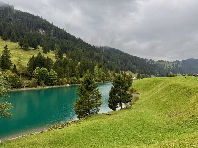
Escape to the heart of the Liechtenstein Alps with the Steg Lakes Loop, an easy and incredibly scenic 1.6 km (1 mile) hike perfect for families and casual walkers. This accessible loop trail near Steg, Liechtenstein, offers quintessential alpine beauty, featuring the pristine waters of Ganglesee and the striking turquoise hues of Stausee Steg.

Discover why this trail is a must-do, providing stunning views of cascading waterfalls, peaceful alpine meadows dotted with charming chalets, the soothing chime of cowbells, and panoramic views of the majestic Liechtenstein Alps. Whether you're searching for easy hikes in Liechtenstein, the best views in Steg, or a relaxing walk around the Ganglesee and Stausee Steg, this detailed guide has everything you need to experience this magical corner of the European Alps.

Steg Lakes Loop: A Scenic 1.6 km Alpine Hike around Ganglesee and Stausee Steg

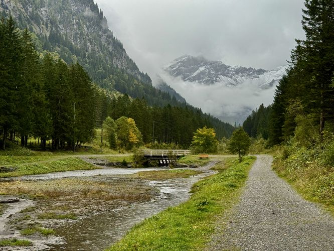
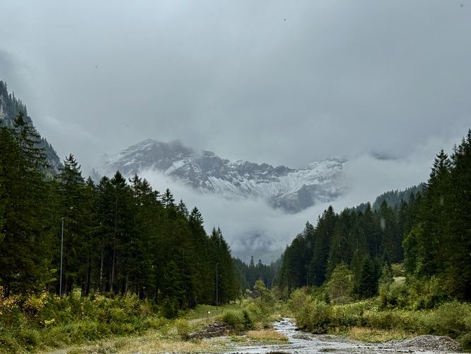
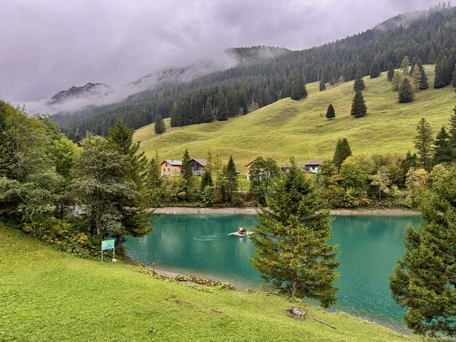
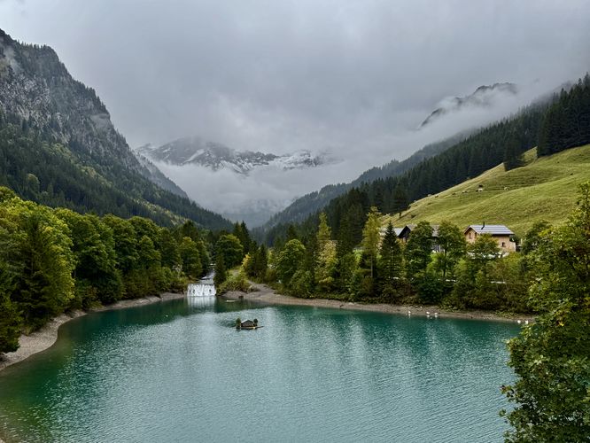
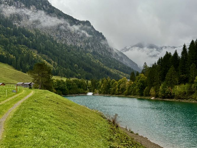
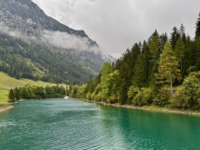
This hike begins on the west side of Ganglesee, along Valünastrasse near Steg and follows the public trail as it leads south along the lake. As you hike south along Ganglesee, hikers will find breathtaking views of the alpine mountains that surround the valley, especially the alpine ridges of Naafkopf and Hinter Grauspitz. As you follow the trail, it eventually leads over a footbridge that span the stream, Valünerbach. From the east side of Ganglesee, the trail runs north as it leads to more viewpoints of this scenic alpine lake and the surrounding mountains. From the north shore of Ganglesee, you'll find more beautiful Alps views to the south and to the north sits the top of the Stausee Steg waterfall.

Alpine Meadows, Panoramic Views, and Turquoise Waters of Stausee Steg

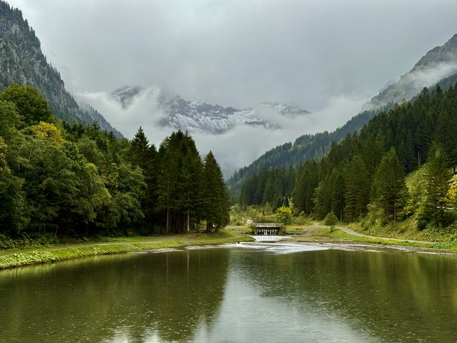
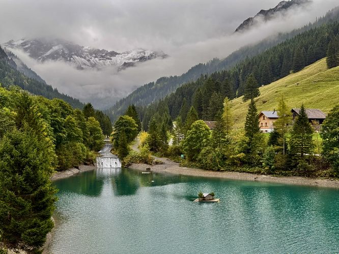
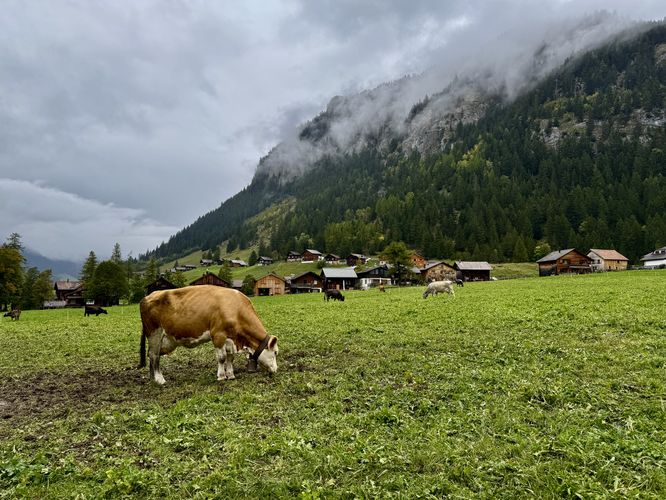
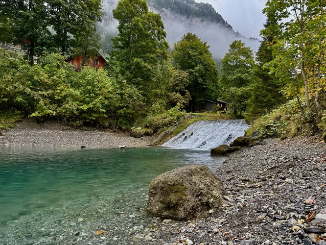
Once you pass the bridge that connects Ganglesee to Stausee Steg, the hike leads north along the east side of Stausee Steg. First, you'll hike past several charming alpine chalets and homes before the trail leads into an open meadow. From the sprawling alpine meadow, during warm months, hikers will find cows grazing on grasses where you can listen to the chime of their cowbells, all while standing under the scenic snow-capped Alps of Liechtenstein. As the trail runs along the top of a hill, high above Stausee Steg, you will find the deep turquoise hues of the lake below your feet. To the south, you'll find views of the waterfall that cascades into Stausee Steg and towering alpine mountains in the valley. The views from this section of the hike are simply unmatched and should not be skipped! The trail eventually loops around Stausee Steg and follows a bridge, with a pump house building, located on the northern reaches of the lake. After crossing the footbridge, the hike leads down the west side of the lake, following Valünastrasse as the main path.

Stausee Steg Waterfall - 1.44 km

Before you reach the parking lot, a small trail leads down to the water's edge of Stausee Steg from Valünastrasse near 1.45 km. Hike this trail for just a short way downhill where you'll find a scenic view of the 4-meter (13-foot) tall waterfall of Stausee Steg. From here, the turquoise waters of Valünerbach flow into Stausee Steg to fill the lake with more colorful hues.

Return to Parking

After exploring the Stausee Steg waterfall, the trail leads right back to the parking lot after hiking back up to Valünastrasse. The hike wraps up at the parking lot for an easy 1.6 km (1 mile) loop hike in Steg, Liechtenstein.

Parking & Directions: Getting to the Steg Lakes Loop

Hikers that wish to explore the lakes in Steg will find a large parking lot on the west side of Valünastrasse near Ganglesee. The parking lot can accommodate approximately 40 vehicles as of September 2025. If driving in from the Liechtenstein valley near Triesen, you will drive up the mountainside and through a tunnel that cuts through the mountain to reach Steg.

Pets

Dogs are allowed only if leashed and must be cleaned up after.
Explore 6 trails near Steg, Liechtenstein
  1. Parking

    47.107295, 9.577128
  2. Main Trailhead

    47.107295, 9.577128
  3. View / Overlook / Vista

    47.106861, 9.577497
    View / Overlook / Vista
  4. View / Overlook / Vista

    47.106053, 9.578047
    View / Overlook / Vista
  5. View / Overlook / Vista

    47.107822, 9.577547
    View / Overlook / Vista
  6. View / Overlook / Vista

    47.109344, 9.577461
    View / Overlook / Vista
  7. View / Overlook / Vista

    47.109597, 9.577286
    View / Overlook / Vista
  8. View / Overlook / Vista

    47.109842, 9.576797
    View / Overlook / Vista
  9. View / Overlook / Vista

    47.109914, 9.576486
    View / Overlook / Vista
  10. Point-of-Interest

    47.110803, 9.574803
    Point-of-Interest
  11. View / Overlook / Vista

    47.110797, 9.574778
    View / Overlook / Vista
  12. View / Overlook / Vista

    47.111081, 9.573822
    View / Overlook / Vista
  13. Waterfall

    47.108483, 9.577114
    Waterfall
No community routes found. To add your own hike as a Community Route for this Trail guide, leave a Trip Report with an attached GPX file.

Seasons

All

Photo Albums

+ Add Photo Album

Upload your photos from the trail to help others know what to expect.

Preview of the MyHikes mobile app interface

Track, Log, and Explore Hikes with the MyHikes App

Shop Landscape Prints
Shop our Alps landscape prints to support MyHikes!

Trip Reports (Reviews)

Ready to help fellow hikers? Add a trip report to share your experience and provide valuable insights for those planning their next hike. Your review makes the trail better for everyone.

Your opinion matters! Be the first to rate this trail.

Explore Hiking Trails

You May Also Like

Colorado's Million Dollar Highway - Plan a day's drive adventure along the iconic Million Dollar Highway in Colorado. Explore the best short trails, roadside stops, waterfalls, vistas, ghost towns, and hot springs within a ~6 hour road trip.
Explore

Colorado's Million Dollar Highway

Plan a day's drive adventure along the iconic Million Dollar Highway in Colorado. Explore the best short trails, roadside stops, waterfalls, vistas, ghost towns, and hot springs within a ~6 hour road trip.

Read
Glacier's Going-to-the-Sun Road - Discover the breathtaking beauty of Glacier National Park along the iconic Going-to-the-Sun Road. From stunning roadside stops to picturesque waterfalls and vistas, this engineering marvel offers endless opportunities for exploration.
Explore

Glacier's Going-to-the-Sun Road

Discover the breathtaking beauty of Glacier National Park along the iconic Going-to-the-Sun Road. From stunning roadside stops to picturesque waterfalls and vistas, this engineering marvel offers endless opportunities for exploration.

Read
New York's Best Waterfalls - Whether you're planning a day hike, roadside stop, or a leisurely short walk, this guide provides hikers, travelers, and locals alike with 63 different locations to over 100 scenic waterfalls to help plan your next adventure!
Explore

New York's Best Waterfalls

Whether you're planning a day hike, roadside stop, or a leisurely short walk, this guide provides hikers, travelers, and locals alike with 63 different locations to over 100 scenic waterfalls to help plan your next adventure!

Read

Before you boogie...

Find our trail guides useful? Consider becoming a Supporter to unlock perks!

MyHikes is an indie platform that makes exploring public trails easier for everyone. The platform has no investors, no ads, and is owned and operated by one person, Dave Miller. Dave has personally mapped and written over 1,900 trail guides on MyHikes for the public to explore. MyHikes has helped millions outdoor enthusiasts plan their next adventure.

But it takes a lot of time 🕦, money 💰, work, and espresso shots ☕ to run MyHikes, including hiking , mapping , writing , and publishing new trails with high-quality (accurate) information... along with software engineering (coding) the platform like building new features, website and mobile app development (iOS and Android), site maintainance . and much much more.

Supporters unlock website and mobile app perks with an annual one-time payment of $25 (you renew) 😎👍. Or you can simply make a Donation of your choice. Otherwise, you can support us by telling your friends about MyHikes - both quick and free 🎉

Admin avatar

Dave Miller
MyHikes Founder
🍪 We use cookies to learn about site usage, performance, and to serve map tiles. You may block cookies manually in the browser. By continuing to use MyHikes, you agree. Learn more