Loading...

🔥 End of Summer sale! 50% off on Supporter Accounts — now through September 1st. Learn More.

Stairway To Heaven Hike

Directions
Map
Pictures
Send to App
Distance:
5.5 Miles / 8.9 km
Type:
Out-and-Back
Difficulty:
Moderate
Time to Hike:
2 hours, ~45 minutes
Features:
Surface Type:
Dirt
Town:
Orkney Springs, Virginia
Directions:
38.793825, -78.815511
Added:
April 03, 2025
Updated:
April 06, 2025
Guide by:
Copy Trail Link Hiking this trail? Send a friend or family member a link to this trail guide for your own safety. Hike at your own risk (disclaimer)
Loading...
Loading...
1,300'

Total Change
1,750'

Ascent
1,760'

Descent

Download the Trail Route for Offline Use

Supporters get exclusive access to download trail routes to the MyHikes app for offline use. Stay prepared on your adventure, even without an internet connection! Become a Supporter today to unlock this feature and hike with confidence.

Send to App

Stairway To Heaven Hike

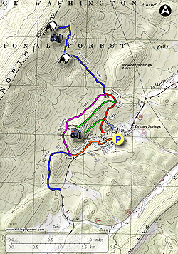
The Shrine Mont conference center and retreat is located near Orkney Springs Virginia on the VA/WV border. There are several nice trails on the property that pass the Cathedral Shrine of the Transfiguration, and the Ridge Trail up to The Cross on Spring Mountain. The most scenic section is the North Mountain Trail that climbs up Great North Mountain. Passing a large cliff structure, the trail ends at North Mountain Rocks with a spectacular view back towards Orkney Springs and the Shenandoah Valley.

Several nice hikes can be put together using the many trails. Our 6.2 mile hike uses the North Link Trail past the Shrine, The Ridge Trail past the Cross, and then takes the North Mountain Trail up to North Mountain Rocks.

NOTE: Dogs and pets are not permitted on Shrine Mont property.

If you are looking for more solitude consider hiking the perimeter trails up to North Mountain Rocks.

  • Mile 0.0 – From the parking area behind the pavilion walk back to the main road and turn left in front of the Virginia House. Follow the road up to the circle and pass through the Shrine Mont entrance. The trailhead for the North Link Trail is located on the right side of the parking area.
  • Mile 0.21 - Start up the North Link Trail and soon arrive at the Cathedral Shrine of the Transfiguration. Turn right following the signs towards The Cross and North Mountain, then in 0.3 miles arrive at the intersection with the Ridge Trail.
  • Mile 0.58 - Turn left towards The Cross on the Ridge Trail. The trail becomes increasingly steeper before arriving at an intersection where the Ridge Trail turns sharply to the right following the ridgeline. Stay right towards The Cross on the Ridge Trail.
  • Mile 1.19 - Arrive at The Cross at the high point on Spring Mountain. There are limited views to the west and east through the trees from the platform. Now continue downhill towards the north for another 0.7 miles where the Ridge Trail ends at the North Link Trail.
  • Mile 1.89 - Turn left and follow the North Link Trail and soon pass a forestry road on the right that leads to Orkney Springs. Cross a small stream then shortly arrive at the inters et ion with the Bradford Trail and North Mountain Trail where the North Link Trail ends.
  • Mile 2.1 - Stay right on the as the North Mountain Trail follows a forestry road for 0.15 miles then turns left off the forestry road towards the ridge. The trail is rocky and gradually increases in grade. In 0.8 miles pass a campsite and large cliff face on the left. After passing the cliff and stream the North Mountain Trail becomes increasingly steeper joining a ridge spur. The trail then turns more southerly and ends before reaching the Great North Mountain ridge at a campsite and North Mountain Rocks.
  • Mile 3.8 - On the opposite side of the campsite is the back of North Mountain Rocks. There is a 10ft climb to get to the top of the rocks where there is a spectacular view of the Shenandoah Valley. From North Mountain Rocks retrace your route back down the North Mountain Trail, rejoin the North Link Trail crossing the stream and arrive back at the intersection with the Ridge Trail.
  • Mile 5.7 - Continue straight on the North Link Trail to the next intersection on the left with a sign for Shrine Mont.
  • Mile 5.9 - Turn left downhill towards Shrine Mont as the trail passes behind cabins, then turns right and ends back at the the Virginia House. Pass back around the Virginia House to the parking area.
  • Mile 6.2 - Arrive back at the parking area.
Explore 81 trails near Orkney Springs, VA
  1. Parking

    38.793825, -78.815511
  2. Main Trailhead

    38.793931, -78.815618
No community routes found. To add your own hike as a Community Route for this Trail guide, leave a Trip Report with an attached GPX file.

Hazards

Ticks - Lyme Disease More Info (CDC)
Snakes
Poison Ivy/Oak

Seasons

All

Photo Albums

+ Add Photo Album

Upload your photos from the trail to help others know what to expect.

Trip Reports (Reviews)

Rated 3.71 out of 5 based on 7 ratings.
By: Kelly L
5.5 miles / 8.9 km
August 28, 2019
The hike itself was good, but the information on the hike found here was confusing. There was no mention of all the stations of the cross plaques found at the beginning of the hike, which is fine but I was surprised. It was helpful to know we were on track. It seemed like the hike information here ended at the large cliff-like rock section, but other reviews mentioned a summit, so we continued on. The two confusing points were 1) I couldn't find any way to see the spectacular views mentioned at the huge cliff-like rocks. and 2) we couldn't figure out where to find the views from the summit either, so we kept going at that point, apparently to nowhere until we finally just turned around. So no spectacular views anywhere from my point of view, but a decent and challenging hike regardless.
Legacy Review
By: Bryan
5.5 miles / 8.9 km
April 01, 2017
Led a group of 11 hikers here on a cloudy Saturday morning after it rained on Friday. It was a good time to hike this trail since the retreat and conference center was a ghost town. The venue opens after Easter until mid-November. The walk up to Orkney Springs and the Cathedral Shrine of the Transfiguration on the North Mountain Trail (Red) was interesting and a different way to begin a hike. We found our way to the Ridge Trail (Green), which is moderately steep, and made our way to the Cross for a very minimal view of the valley. We reconnected with the North Mountain Trail and made our way up to the rocks. This trail is the only marked trail in the property. The ascent was a steady and rocky incline – moderately difficult in some spots. We had to be careful of several large puddles of water and two stream crossings. The large cliff face was a good “halfway point”. It was an impressive structure and impressive and appears that other hikers (or locals) used as shelter or campsite before. The view from the rocks at the top was amazing! We took the same trail down and instead of navigating back to Shrine Mont, we continued on the “Orkney Springs” option, which dropped us off on Orkney Springs Grade Road – about a mile from the retreat and conference center. There were not any other hikers on the trail that day. Would recommend hiking trail in early Spring or peak Fall season
Legacy Review
By: Hikerfamily
5.5 miles / 8.9 km
August 27, 2016
This hike had some pretty great views. Wouldn't reccomend for beginners. Steep and rocky incline towards the summit. Saw one bear on the Bradford trail. Only saw a couple other hikers on our way down.
Legacy Review

Weather Forecast

In Orkney Springs, VA

Explore Hiking Trails

You May Also Like

New York's Best Waterfalls - Whether you're planning a day hike, roadside stop, or a leisurely short walk, this guide provides hikers, travelers, and locals alike with 63 different locations to over 100 scenic waterfalls to help plan your next adventure!
Explore

New York's Best Waterfalls

Whether you're planning a day hike, roadside stop, or a leisurely short walk, this guide provides hikers, travelers, and locals alike with 63 different locations to over 100 scenic waterfalls to help plan your next adventure!

Read
25 Best Day Hikes in North Carolina - Discover the top 25 best day hikes in North Carolina, from breathtaking waterfalls to mountain peaks. Explore hidden gems, scenic views, and trails suitable for all skill levels, perfect for your next outdoor adventure.
Explore

25 Best Day Hikes in North Carolina

Discover the top 25 best day hikes in North Carolina, from breathtaking waterfalls to mountain peaks. Explore hidden gems, scenic views, and trails suitable for all skill levels, perfect for your next outdoor adventure.

Read

Before you boogie...

Find our trail guides useful? Consider becoming a Supporter to unlock perks!

MyHikes is an indie platform that makes exploring public trails easier for everyone. The platform has no investors, no ads, and is owned and operated by one person, Dave Miller. Dave has personally mapped and written over 1,800 trail guides on MyHikes for the public to explore. MyHikes has helped millions outdoor enthusiasts plan their next adventure.

But it takes a lot of time 🕦, money 💰, work, and espresso shots ☕ to run MyHikes, including hiking , mapping , writing , and publishing new trails with high-quality (accurate) information... along with software engineering (coding) the platform like building new features, website and mobile app development (iOS and Android), site maintainance . and much much more.

Supporters unlock website and mobile app perks with an annual one-time payment of $25 (you renew) 😎👍. Or you can simply make a Donation of your choice. Otherwise, you can support us by telling your friends about MyHikes - both quick and free 🎉

Admin user profile picture

Dave Miller
MyHikes Founder