Loading...

๐ŸŽ† 50% off 4th of July sale on Supporter Accounts โ€” now through July 6! Learn More.

Spruce Nature Trail

Directions
Map
Pictures
Send to App
Distance:
1.1 Miles / 1.8 km
Type:
Loop
Difficulty:
Easy
Time to Hike:
~33 minutes
Features:
Surface Type:
Dirt
Park:
Olympic National Park
Town:
Forks, Washington
Directions:
47.860349, -123.934782
Added:
June 15, 2025
Updated:
June 28, 2025
Copy Trail Link Hiking this trail? Send a friend or family member a link to this trail guide for your own safety. Hike at your own risk (disclaimer)
Loading...
Loading...
46'

Total Change
37'

Ascent
30'

Descent

Download the Trail Route for Offline Use

Supporters get exclusive access to download trail routes to the MyHikes app for offline use. Stay prepared on your adventure, even without an internet connection! Become a Supporter today to unlock this feature and hike with confidence.

Send to App

Spruce Nature Trail

The Spruce Nature Trail at Olympic National Park near Forks, Washington is an easy 1.1-mile loop hike that leads through the Hoh Rainforest where visitors will find lush mosses and ferns and views of the Hoh River within an old-growth forest.

Explore the Hoh Rainforest via Spruce Trail

Hikers will find the trailhead for the Spruce Nature Trail located just off of the Mini Trail that leads in from the main parking lot. While the Spruce Nature Trail is a bit less spectacular than the Hall of Mosses Trail, it's a great way to expand your visit in the Hoh Rainforest and to take-in more scenery that the area has to offer. If you show up early enough, like we did, and had the Hall of Mosses Trail virtually to yourself, then exploring this trail afterward is a great way to continue that seclusion as most hikers visit this trail second.

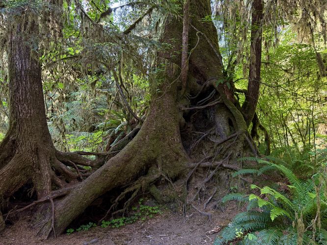
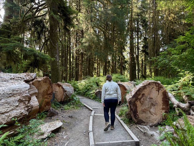
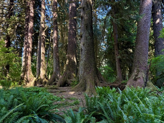
The path passes the Hoh River Trail before it splits at a fork where visitors can choose which direction they wish to hike the loop. This guide follows the Spruce Nature Trail in a clockwise direction. As you follow the path through the lush vegetation of the Hoh Rainforest, you'll initially find towering old-growth trees that reach hundreds of feet toward the sky. You'll pass a small cluster of trees on your left-hand side with tall and gnarled roots that once grew down and around a long-dead nurselog. Further ahead, around mile 0.35 is an information kiosk about the age of the forest where, just beyond, are blowdown trees that were cut away for hikers to pass through โ€” as you pass these crosscut trees, you'll find their width is almost 5-feet high.

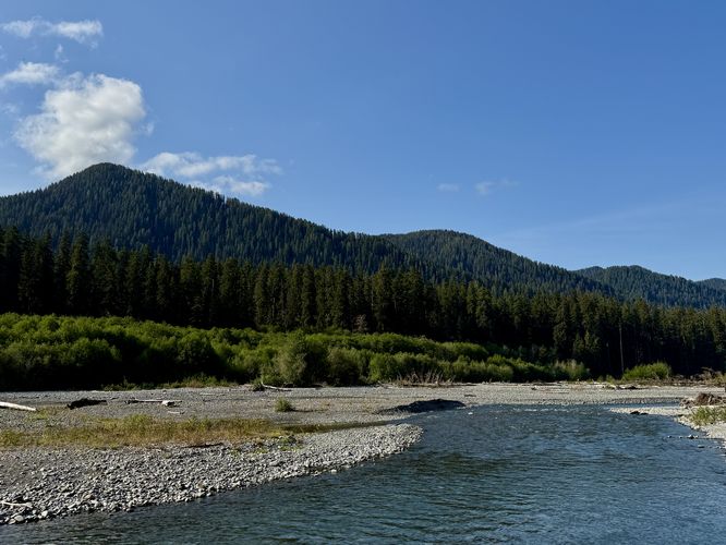
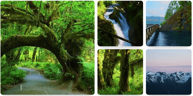
Hoh River Viewpoint - Mile 0.48

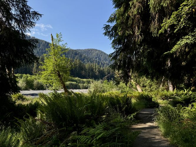
Close to the half-way point sits a short out-and-back spur trail that leads to a viewpoint of the Hoh River. Here, the forest opens to bright and harsh daylight with the river flowing below and mountains surrounding its banks. This is a great spot to take a short break and to take in different scenery.

Arch Tree & Root Wall - Mile 0.63

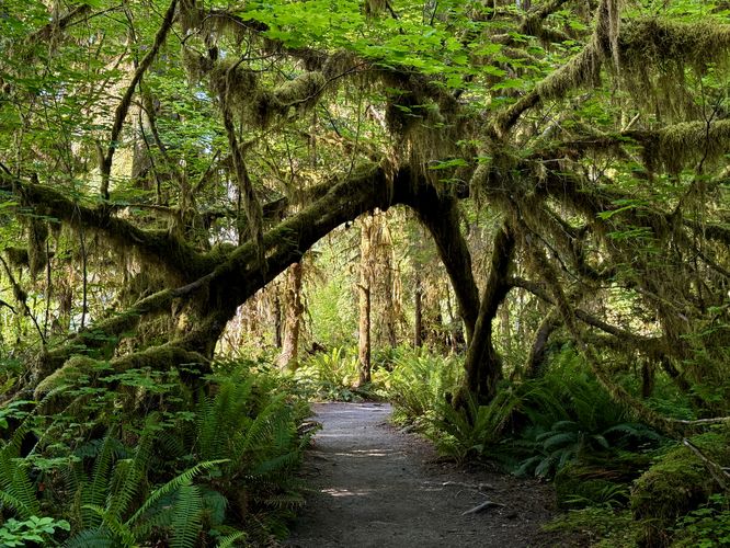
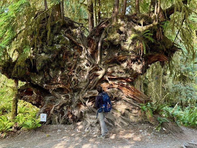
Just down the trail from the Hoh River viewpoint are two really neat points-of-interest for hikers. First up is the moss-covered arch tree that curves over the pathway. It's a great spot to take photos, especially if you have a hiking companion to show the scale of the forest. Just beyond sits a very-tall root wall that was exposed by a fallen tree. This root wall is approximately 13-feet tall with new growth trees that adorn the top of it. This fallen tree has turned into a nurselog where the top of the root wall is already helping new trees thrive. Do not climb the wall for your own safety and preservation of nature.

Nurselog Tree Row - Mile 0.8

After passing the root wall, hikers will meander through the Hoh Rainforest before the path curves around to head westward back to the trailhead. Along the way, at mile 0.8, is another neat point-of-interest where you'll find large old-growth trees that grew in a straight line. This is another example of the result of a nurselog โ€” a tree that fell and its decaying matter allowed for new trees to grow on top and around it. Competition in the forest is fierce, so only the strongest trees will survive on the nurselog, hence there are about 7 old-growth trees that survived thanks to the decaying nurselog.

Taft Creek Views - Mile 0.97 to 1

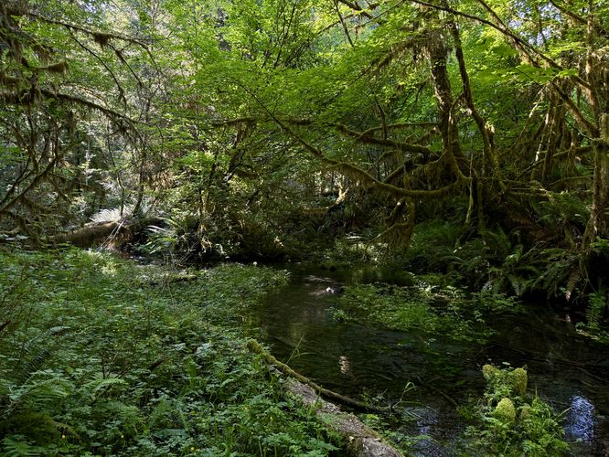
The last POI along the hike are views of Taft Creek as the trail traverses the forest alongside the water's edge. Taft Creek is a crystal-clear stream and makes for interesting, but difficult to shoot, photos.

The trail wraps up back at the trailhead for a 1.1-mile loop hike.

Other Hikes in the Hoh Rainforest

Before you leave the area, you should consider hiking the Hall of Mosses Trail โ€” which is by far the most popular hike here. Or you can consider hiking the Hoh River Trail, which technically is a very-long path that leads through the Hoh Rainforest for many miles and runs near the Hoh River. Due to a lack of time and more sights to see, our Hoh River Trail guide follows a short out-and-back 2-mile jaunt to explore its sights.

Parking & Fees

Hikers will find a massive parking lot at the coordinates provided, located at the end of the Upper Hoh Road. The lot is large enough to fit many dozens of vehicles as of June 2025. There's additional parking at a nearby parking lot just west of the main parking area. Note that the Hoh Rainforest is a very-popular destination for hikers and during peak season, the parking lot may be very difficult to get into if you show up at the wrong time. Long wait times may prevail. Last, to enter the park here, you must pay an entrance fee, per vehicle of about $25 which is generally good to re-enter the park for several days as of 2025. You can save time and save yourself multiple park entrance fees by purchasing an Annual National Parks Pass ahead of time.

Pets

Dogs are not allowed on this trail or any trails within the Hoh Rainforest area. Please leave your pets at home.

Warning

Wildlife: In the late spring and early summer, elk are calving which means that they're more aggressive than usual. If you spot any elk, especially with calves (small babies), be extra cautious and give the animals plenty of space. Angry elk are known to trample and charge people if they get too close.
Explore 13 trails near Forks, WA
  1. Parking

    47.860349, -123.934782
  2. Main Trailhead

    47.861102, -123.933754
  3. Tangled roots of trees that once grew out of a nurselog

    47.860747, -123.928436
    Tangled roots of trees that once grew out of a nurselog
  4. ~5-foot thick fallen trees abut the trail

    47.859944, -123.927536
    ~5-foot thick fallen trees abut the trail
  5. Hoh River Viewpoint

    47.859367, -123.925972
    Hoh River Viewpoint
  6. Views of mountains that surround the Hoh River as seen from the trail

    47.859456, -123.926256
    Views of mountains that surround the Hoh River as seen from the trail
  7. Arch tree

    47.858647, -123.927772
    Arch tree
  8. Trees growing in a row on an old nurselog

    47.857811, -123.930114
    Trees growing in a row on an old nurselog
  9. View of Taft Creek from the trail

    47.860272, -123.931794
    View of Taft Creek from the trail
  10. Root wall (do not climb!)

    47.858433, -123.927925
    Root wall (do not climb!)
No community routes found. To add your own hike as a Community Route for this Trail guide, leave a Trip Report with an attached GPX file.

Seasons

All

Trip Reports

Trail Guide By:
Admin user profile picture
1.1 miles / 1.8 km

Weather Forecast

In Forks, WA

Explore Hiking Trails

You May Also Like

Colorado's Million Dollar Highway - Plan a day's drive adventure along the iconic Million Dollar Highway in Colorado. Explore the best short trails, roadside stops, waterfalls, vistas, ghost towns, and hot springs within a ~6 hour road trip.
Explore

Colorado's Million Dollar Highway

Plan a day's drive adventure along the iconic Million Dollar Highway in Colorado. Explore the best short trails, roadside stops, waterfalls, vistas, ghost towns, and hot springs within a ~6 hour road trip.

Read
Glacier's Going-to-the-Sun Road - Discover the breathtaking beauty of Glacier National Park along the iconic Going-to-the-Sun Road. From stunning roadside stops to picturesque waterfalls and vistas, this engineering marvel offers endless opportunities for exploration.
Explore

Glacier's Going-to-the-Sun Road

Discover the breathtaking beauty of Glacier National Park along the iconic Going-to-the-Sun Road. From stunning roadside stops to picturesque waterfalls and vistas, this engineering marvel offers endless opportunities for exploration.

Read
New York's Best Waterfalls - Whether you're planning a day hike, roadside stop, or a leisurely short walk, this guide provides hikers, travelers, and locals alike with 63 different locations to over 100 scenic waterfalls to help plan your next adventure!
Explore

New York's Best Waterfalls

Whether you're planning a day hike, roadside stop, or a leisurely short walk, this guide provides hikers, travelers, and locals alike with 63 different locations to over 100 scenic waterfalls to help plan your next adventure!

Read

Before you boogie...

Find our trail guides useful? Consider becoming a Supporter to unlock perks!

MyHikes is an indie platform that makes exploring public trails easier for everyone. The platform has no investors, no ads, and is owned and operated by one person, Dave Miller. Dave has personally mapped and written over 1,800 trail guides on MyHikes for the public to explore. MyHikes has helped millions outdoor enthusiasts plan their next adventure.

But it takes a lot of time ๐Ÿ•ฆ, money ๐Ÿ’ฐ, work, and espresso shots โ˜• to run MyHikes, including hiking , mapping , writing , and publishing new trails with high-quality (accurate) information... along with software engineering (coding) the platform like building new features, website and mobile app development (iOS and Android), site maintainance . and much much more.

Supporters unlock website and mobile app perks with an annual one-time payment of $25 (you renew) ๐Ÿ˜Ž๐Ÿ‘. Or you can simply make a Donation of your choice. Otherwise, you can support us by telling your friends about MyHikes - both quick and free ๐ŸŽ‰

Admin user profile picture

Dave Miller
MyHikes Founder