Maple Spring Loop Trail
This trail is moderately-trafficked, but a lot less popular than the Corrigan Walkway Trail. You can also connect to the Bison Ridge Loop Trail along various points on the Maple Spring Loop.
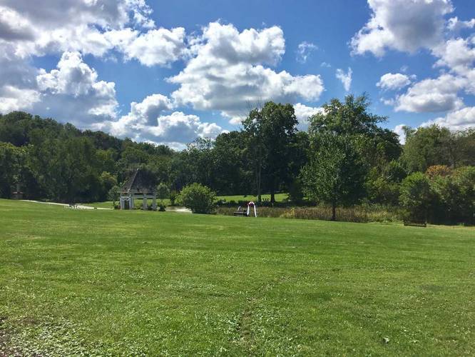
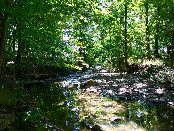
At the southern end of the loop is a small creek that runs by the trail. On the northern section of the loop has a small pond with a gazebo.
Know Before You Go
Interactive topographic map for Maple Spring Loop Trail located in South Park Township, PA. Click the "View Map" button to load GPS coordinates and trail markers.
View map
Get directions
- Distance
- 1.8 mi
- Difficulty
- Easy
- Type
- Loop
- Est. Time
- 54 min
- Elev. Gain
- 156'
- Rating
- 0.0
- Added
- September 09, 2017
- Updated
- June 10, 2018
Weather Forecast
This Afternoon
High
83°F
Partly Sunny
Tonight
Low
64°F
Chance Showers And Thunderstorms then Partly Cloudy
Monday
High
86°F
Partly Sunny then Slight Chance Showers And Thunderstorms
Monday Night
Low
67°F
Chance Showers And Thunderstorms
Tuesday
High
80°F
Showers And Thunderstorms
Tuesday Night
Low
64°F
Showers And Thunderstorms then Slight Chance Showers And Thunderstorms
Wednesday
High
79°F
Slight Chance Rain Showers then Chance Showers And Thunderstorms
Wednesday Night
Low
61°F
Chance Showers And Thunderstorms then Partly Cloudy
Thursday
High
81°F
Mostly Sunny
Thursday Night
Low
61°F
Mostly Clear
Friday
High
83°F
Mostly Sunny
Friday Night
Low
65°F
Mostly Cloudy
Saturday
High
84°F
Chance Showers And Thunderstorms
Saturday Night
Low
66°F
Chance Showers And Thunderstorms
Don't let Google decide who you trust.


Loading...
<strong>Trail map and elevation chart not rendering in print mode?</strong> Simply scroll to the trail map section, then try printing again!
Total Change
93 ft.
28 m
28 m
Ascent
156 ft.
48 m
48 m
Descent
155 ft.
47 m
47 m
Loading...
Features
- Dogs
Points of interest
-
Parking
40.307753, -79.999599 -
Main Trailhead
40.315426, -80.005825 -
Fields with a gazebo and pond
40.315972, -80.000617 -
Creek
40.308972, -80.000642
Safety information
For your own safety: plan ahead, let someone know where you'll be, and hike at your own risk.
Availability
All seasons
Surface type
Dirt
Trip Reports (Reviews)
Ready to help fellow hikers? Add a trip report to share your experience!
No community routes found. To add your own hike as a Community Route for this Trail guide, leave a Trip Report with an attached GPX file.


You may also like

Explore
Pennsylvania's Grand Canyon
Explore Pennsylvania's Grand Canyon, officially named Pine Creek Gorge, including hiking trails, vistas, overlooks, waterfalls, backcountry campsites, backpacking trails.

Explore
New York's Best Waterfalls
Whether you're planning a day hike, roadside stop, or a leisurely short walk, this guide provides hikers, travelers, and locals alike with 63 different locations to over 100 scenic waterfalls to help plan your next adventure!

Explore
25 Best Day Hikes in West Virginia
Discover 25 of the best day hikes in West Virginia, from scenic overlooks to wilderness trails—perfect for every level of hiker.

Explore
Best of the Alps: Hiking, Adventure & Scenery
Plan your ultimate European Alps adventure! Discover the best hiking trails, epic scenery, and villages in the Swiss Alps, Dolomites, Chamonix, and Lake Como.
south park

