Loading...

🎉 Enjoy a Free 7-Day Supporter Trial and Unlock Exclusive Perks — No Credit Card Required. Learn more.

Snowball Trail Hike

Directions
Map
Pictures
Send to App
Distance:
7.0 Miles / 11.3 km
Type:
Out-and-Back
Difficulty:
Moderate
Time to Hike:
3 hours, ~27 minutes
Features:
Surface Type:
Dirt
Park:
Pisgah National Forest
Town:
Barnardsville, North Carolina
Directions:
35.699993, -82.398856
Added:
March 13, 2025
Updated:
April 05, 2025
Copy Trail Link Hiking this trail? Send a friend or family member a link to this trail guide for your own safety. Hike at your own risk (disclaimer)
Loading...
Loading...
977'

Total Change
2,408'

Ascent
2,404'

Descent

Download the Trail Route for Offline Use

Supporters get exclusive access to download trail routes to the MyHikes app for offline use. Stay prepared on your adventure, even without an internet connection! Become a Supporter today to unlock this feature and hike with confidence.

Send to App

Snowball Trail Hike

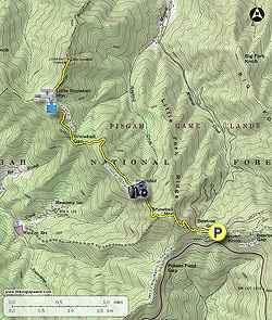
he Snowball Trail is a quiet alternative to the crowds of the Craggy Gardens Recreation Area along the Blue Ridge Parkway. Beginning at Beetree Gap near the picnic area, you’ll follow the trail north into the heart of the western Great Craggy Mountains. The trail follows a high ridge dividing the headwaters of Reems Creek and Ivy Creek in the Big Ivy region of Pisgah National Forest. The highlight of the hike is Hawkbill Rock, an exposed peak with wide-ranging views of the Black, Great Craggy, and Elk Mountains. Most visitors will turn around here, as it is a short, rewarding 2.8-mile round trip. The Snowball Trail continues north along a wide ridge which holds an impressive old-growth hardwood forest. The terminus of the trail is Little Snowball Mountain-Northeast Peak, the site of a former lookout tower. Reaching this peak is one half of the Little Snowball tower requirement for the Carolina Lookout Tower Challenge. Although the former tower site no longer has views, the last half-mile is an incredible walk through a tunnel of Catawba rhododendron and mountain laurel blooms during May and June.

Carolina Lookout Tower Challenge – To check off Little Snowball for the Carolina Lookout Tower Challenge, you must hike the Snowball Trail to the former tower site on Little Snowball Mountain-Northeast Peak and also visit the restored tower at the Big Ivy Historical Campus. The tower was rebuilt in 2006 and is beside the main parking lot for the Big Ivy Community Center. If the gate is open at Beetree Gap, you can follow FR 63 north to the community of Dillingham and follow Dillingham Rd west to the park.


  • Mile 0.0 – The paved road to the Craggy Gardens Picnic Area passes through a T-intersection with FR 63/Stoney Fork Rd at Beetree Gap. Find a parking spot at this junction near the FR 63 gate. Follow the Mountains-to-Sea Trail [440] (white blaze) west from the intersection.
  • Mile 0.1 – At a Y-junction the MST turns left while the Snowball Trail [170] (white or yellow blaze) begins straight ahead. For the next 0.6-mi you’ll climb over 450 feet towards the top of Snowball Mountain.
  • Mile 0.7 – The trail skirts to the right of the summit of Snowball Mountain (5,380 feet), which is densely covered in shrubs and has no views.
  • Mile 0.9 – Pass by an unmarked trail on the left which heads towards the Woodfin Reservoir. The Snowball Trail turns right. After one switchback the trail descends along an increasingly narrow ridge. This section is lined with Catawba rhododendron and mountain laurel, making it especially beautiful during May and June when the flowers are blooming.
  • Mile 1.4 – After a final rock scramble you’ll reach Hawkbill Rock (4,960 feet). To the left of the trail are a series of rock outcroppings with 180° views of the Black Mountains, Great Craggy Mountains, and Elk Mountains. You have a big view east of the Great Craggy and Black Mountains surrounding the remote headwaters of Ivy Creek. Due east is Bullhead Mountain, with Craggy Dome and Craggy Pinnacle the closest peaks directly right. Further east the dominant ridge with blackish trees leads to Blackstock Knob. Snowball Mountain rises above the Snowball Trail immediately south. To the west are the smaller Great Craggy Mountains which transition to the Elk Mountains at Bull Gap. The tall, double peaks on the left are Lane Pinnacle and its false summit. The Elk Mountains drop quickly into the Reems Creek Valley further west, with the Bald Mountains in the distance.
  • Mile 1.6 – On the northwest side of Hawkbill Rock the trail meanders through a wide plateau with an impressive collection of old-growth trees.
  • Mile 2.5 – The Snowball Trail passes through the long, shallow Snowball Gap. At the north side of the gap is a Y-junction with an unmarked trail going left following the ridgeline towards a knob. Turn right and begin following an old forest road.
  • Mile 3.0 – Y-junction with the unmarked ridgeline trail on the left.
  • Mile 3.1 – An old steel-door piped spring box is located on the left side of the trail below Little Snowball Mountain.
  • Mile 3.2 – The trail levels out on its final approach to the lookout tower site, passing through a tunnel of Catawba rhododendron and mountain laurel. This is a premier wildflower destination.
  • Mile 3.6 – Reach Little Snowball Mountain-Northeast Peak (4,740 feet), the former site of the Little Snowball lookout tower. The tower was removed in 1980, all that remains are the concrete footings. Unfortunately, without the tower you will get no views from this small, grassy summit which is surrounded by trees. Turn around and make your way back towards Beetree Gap.  
  • Mile 7.0 – Hike ends at Beetree Gap.
By HikingUpward Contributor: Zach Robbins
Explore 30 trails near Barnardsville, NC
  1. Parking

    35.699993, -82.398856
  2. Main Trailhead

    35.699826, -82.398791
No community routes found. To add your own hike as a Community Route for this Trail guide, leave a Trip Report with an attached GPX file.

Hazards

Snakes
Poison Ivy/Oak

Seasons

All

Blaze Color

Yellow

Trip Reports

Trail Guide By:
HikingUpward user profile picture
7.0 miles / 11.3 km

Weather Forecast

In Barnardsville, NC

Explore Hiking Trails

You May Also Like

Colorado's Million Dollar Highway - Plan a day's drive adventure along the iconic Million Dollar Highway in Colorado. Explore the best short trails, roadside stops, waterfalls, vistas, ghost towns, and hot springs within a ~6 hour road trip.
Explore

Colorado's Million Dollar Highway

Plan a day's drive adventure along the iconic Million Dollar Highway in Colorado. Explore the best short trails, roadside stops, waterfalls, vistas, ghost towns, and hot springs within a ~6 hour road trip.

Read
Glacier's Going-to-the-Sun Road - Discover the breathtaking beauty of Glacier National Park along the iconic Going-to-the-Sun Road. From stunning roadside stops to picturesque waterfalls and vistas, this engineering marvel offers endless opportunities for exploration.
Explore

Glacier's Going-to-the-Sun Road

Discover the breathtaking beauty of Glacier National Park along the iconic Going-to-the-Sun Road. From stunning roadside stops to picturesque waterfalls and vistas, this engineering marvel offers endless opportunities for exploration.

Read
New York's Best Waterfalls - Whether you're planning a day hike, roadside stop, or a leisurely short walk, this guide provides hikers, travelers, and locals alike with 63 different locations to over 100 scenic waterfalls to help plan your next adventure!
Explore

New York's Best Waterfalls

Whether you're planning a day hike, roadside stop, or a leisurely short walk, this guide provides hikers, travelers, and locals alike with 63 different locations to over 100 scenic waterfalls to help plan your next adventure!

Read
25 Best Day Hikes in North Carolina - Discover the top 25 best day hikes in North Carolina, from breathtaking waterfalls to mountain peaks. Explore hidden gems, scenic views, and trails suitable for all skill levels, perfect for your next outdoor adventure.
Explore

25 Best Day Hikes in North Carolina

Discover the top 25 best day hikes in North Carolina, from breathtaking waterfalls to mountain peaks. Explore hidden gems, scenic views, and trails suitable for all skill levels, perfect for your next outdoor adventure.

Read

Before you boogie...

Find our trail guides useful? Consider becoming a Supporter to unlock perks!

MyHikes is an indie platform that makes exploring public trails easier for everyone. The platform has no investors, no ads, and is owned and operated by one person, Dave Miller. Dave has personally mapped and written over 1,800 trail guides on MyHikes for the public to explore. MyHikes has helped millions outdoor enthusiasts plan their next adventure.

But it takes a lot of time 🕦, money 💰, work, and espresso shots ☕ to run MyHikes, including hiking , mapping , writing , and publishing new trails with high-quality (accurate) information... along with software engineering (coding) the platform like building new features, website and mobile app development (iOS and Android), site maintainance . and much much more.

Supporters unlock website and mobile app perks with an annual one-time payment of $25 (you renew) 😎👍. Or you can simply make a Donation of your choice. Otherwise, you can support us by telling your friends about MyHikes - both quick and free 🎉

Admin user profile picture

Dave Miller
MyHikes Founder