Loading...

Distance:
0.2 Miles / 0.3 km
Type:
Out-and-Back
Difficulty:
Moderate
Time to Hike:
~6 minutes
Features:
Surface Type:
Dirt
Park:
Capitol Reef National Park
Town:
Wayne County, Utah
Directions:
38.224408, -111.22042
Added:
September 28, 2023
Updated:
October 04, 2023
Loading...
Loading...
49 '

Total Change
53 '

Ascent
53 '

Descent

Slickrock Divide Vista at Capitol Reef National Park in Wayne County, Utah is a moderate 0.2-mile out-and-back hike that features stunning valley views within the Waterpocket Fold.

Hike Description
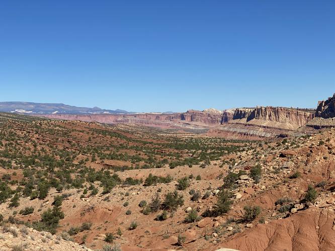
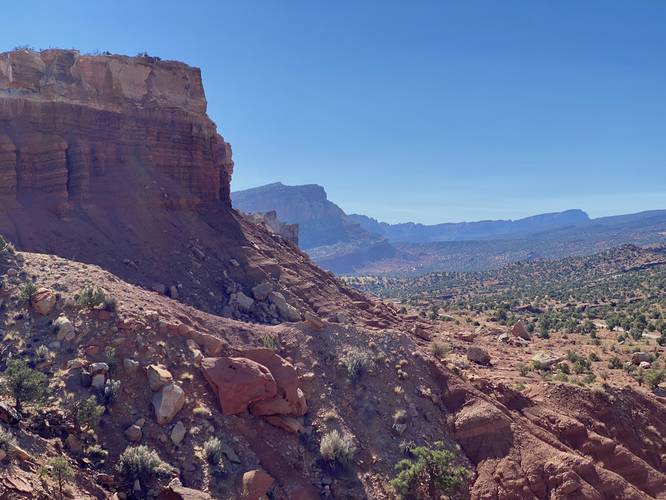
This hike begins along the Capitol Reef Scenic Drive, at the coordinates provided, and heads uphill along a short trail on the eastern side of the road. The trail leads uphill at a moderate elevation grade and ends at the top of a hill with stunning views into the valley facing both north and south. Slickrock Divide separates two large drainages on either side of the hill. Runoff from rain is channeled into Grand Wash to the north, and Capitol Gorge to the south, hence the name Slickrock Divide.

Parking
Hikers will find parking at the coordinates provided, located on the western side of Capitol Reef Scenic Drive.

Pets
Dogs are not allowed on this trail.

Explore 21 trails near Wayne County, UT
  1. Parking

    38.224408, -111.22042
  2. Main Trailhead

    38.224471, -111.220351
  3. View from Slickrock Divide at Capitol Reef National Park

    38.225103, -111.219247
    View from Slickrock Divide at Capitol Reef National Park
  4. View from Slickrock Divide at Capitol Reef National Park

    38.225089, -111.219231
    View from Slickrock Divide at Capitol Reef National Park
No community routes found. To add your own hike as a Community Route for this Trail guide, leave a Trip Report with an attached GPX file.

Hazards

Snakes

Seasons

All

Photo Albums

1 Trip Report

No Star-Ratings
Write-up by:
Admin user profile picture
0.2 miles / 0.3 km
Trail added
September 28, 2023
Hiked on
September 27, 2023
Updated on
October 04, 2023

Weather Forecast

In Wayne County, UT

Explore Hiking Trails

New Hikes

Brittlebank Park Pier Trail
0.2 Miles
0.3 km
Easy
Out-and-Back
Lower Ammonoosuc Falls Trail
1.1 Miles
1.8 km
Easy
Out-and-Back
Upper Rattler Run Falls
1.9 Miles
3.1 km
Hard
Out-and-Back
Peachtree Rock and Waterfall Hike
1 Mile
1.6 km
Moderate
Out-and-Back

Before you leave...

MyHikes is an indie web platform aimed to make exploring public trails easier for everyone. The site has no investors and is owned and operated by one person, Dave Miller (Founder & Admin). As the Founder, main contributor, and doer-of-all-things for MyHikes, I share my trips with over-detailed write-ups for fun on a volunteer basis and I believe that public trail information should be available to everyone.

It takes a lot of time 🕦, money 💰, and effort (including espresso shots ☕) to run MyHikes, including hiking , mapping , writing , and publishing new trails with high-quality content... along with building new features, moderating, site maintainance, and app development for iOS and Android . I simply ask that if you find MyHikes' trail guides helpful to please consider becoming a Supporter to help keep the site, iOS, and Android apps available to everyone.

Supporters unlock website and in-app perks with a one-time payment of $25 (you renew) 😎👍. Or you can simply make a Donation of your choice without a MyHikes user account. Otherwise, telling your friends about MyHikes is the next-best thing - both quick and free 🎉

Thanks for visiting MyHikes and have a great hike!️

Admin user profile picture

Dave Miller
MyHikes Founder & Admin