Loading...

๐ŸŽ‰ Enjoy a Free 7-Day Supporter Trial and Unlock Exclusive Perks โ€” No Credit Card Required. Learn more.

Slacker Ridge Trail

Directions
Map
Pictures
Send to App
Distance:
0.5 Miles / 0.8 km
Type:
Out-and-Back
Difficulty:
Easy
Time to Hike:
~15 minutes
Features:
Surface Type:
Dirt
Park:
Marin Headlands
Town:
Sausalito, California
Directions:
37.833698, -122.494174
Added:
May 19, 2018
Updated:
February 12, 2019
Copy Trail Link Hiking this trail? Send a friend or family member a link to this trail guide for your own safety. Hike at your own risk (disclaimer)
Loading...
Loading...
177'

Total Change
194'

Ascent
194'

Descent

Download the Trail Route for Offline Use

Supporters get exclusive access to download trail routes to the MyHikes app for offline use. Stay prepared on your adventure, even without an internet connection! Become a Supporter today to unlock this feature and hike with confidence.

Send to App

Slacker Ridge Trail

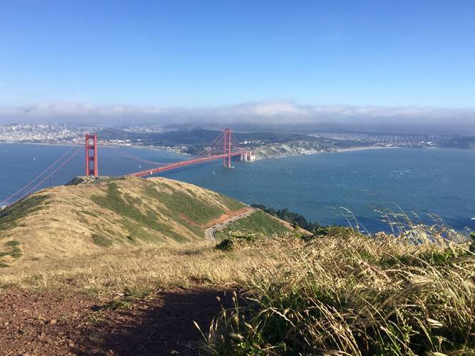
The Slacker Ridge Trail at Marin Highlands, in the Golden Gate National Recreation Area, in Sausalito, California is an easy 0.5 mile out-and-back trail that leads from the Slacker Trail up to the top of Slackers Hill. The view from the top of Slackers Hill is well worth the short hike up, with a view of the Golden Gate Bridge, San Francisco, the bay, and the surrounding hills.

This trail has a gradual uphill climb from the trailhead and is for the most part an easy hike; however, you must hike up the Slacker Trail first, which has a much steeper grade.

Lookout Points: The first lookout can be found near the edge of the trail at what appears to be a fork in the trail (stay right) with views of the bay. The second lookout is at the top of Slackers Hill, which gives a 360-degree view of the San Francisco Bay area.
Explore 28 trails near Sausalito, CA
  1. Parking

    37.833698, -122.494174
  2. Main Trailhead

    37.836537, -122.492155
  3. View / Overlook / Vista

    37.834872, -122.489464
    View / Overlook / Vista
No community routes found. To add your own hike as a Community Route for this Trail guide, leave a Trip Report with an attached GPX file.

Hazards

Ticks - Lyme Disease More Info (CDC)

Seasons

All

Trip Reports

Trail Guide By:
Admin user profile picture
0.5 miles / 0.8 km

Weather Forecast

In Sausalito, CA

Explore Hiking Trails

You May Also Like

Colorado's Million Dollar Highway - Plan a day's drive adventure along the iconic Million Dollar Highway in Colorado. Explore the best short trails, roadside stops, waterfalls, vistas, ghost towns, and hot springs within a ~6 hour road trip.
Explore

Colorado's Million Dollar Highway

Plan a day's drive adventure along the iconic Million Dollar Highway in Colorado. Explore the best short trails, roadside stops, waterfalls, vistas, ghost towns, and hot springs within a ~6 hour road trip.

Read
Glacier's Going-to-the-Sun Road - Discover the breathtaking beauty of Glacier National Park along the iconic Going-to-the-Sun Road. From stunning roadside stops to picturesque waterfalls and vistas, this engineering marvel offers endless opportunities for exploration.
Explore

Glacier's Going-to-the-Sun Road

Discover the breathtaking beauty of Glacier National Park along the iconic Going-to-the-Sun Road. From stunning roadside stops to picturesque waterfalls and vistas, this engineering marvel offers endless opportunities for exploration.

Read
New York's Best Waterfalls - Whether you're planning a day hike, roadside stop, or a leisurely short walk, this guide provides hikers, travelers, and locals alike with 63 different locations to over 100 scenic waterfalls to help plan your next adventure!
Explore

New York's Best Waterfalls

Whether you're planning a day hike, roadside stop, or a leisurely short walk, this guide provides hikers, travelers, and locals alike with 63 different locations to over 100 scenic waterfalls to help plan your next adventure!

Read

Before you boogie...

Find our trail guides useful? Consider becoming a Supporter to unlock perks!

MyHikes is an indie platform that makes exploring public trails easier for everyone. The platform has no investors, no ads, and is owned and operated by one person, Dave Miller. Dave has personally mapped and written over 1,800 trail guides on MyHikes for the public to explore. MyHikes has helped millions outdoor enthusiasts plan their next adventure.

But it takes a lot of time ๐Ÿ•ฆ, money ๐Ÿ’ฐ, work, and espresso shots โ˜• to run MyHikes, including hiking , mapping , writing , and publishing new trails with high-quality (accurate) information... along with software engineering (coding) the platform like building new features, website and mobile app development (iOS and Android), site maintainance . and much much more.

Supporters unlock website and mobile app perks with an annual one-time payment of $25 (you renew) ๐Ÿ˜Ž๐Ÿ‘. Or you can simply make a Donation of your choice. Otherwise, you can support us by telling your friends about MyHikes - both quick and free ๐ŸŽ‰

Admin user profile picture

Dave Miller
MyHikes Founder