With a large picnic area
and many interconnecting trails, including the newer James Ball,
Corporal Morgan, and Hadows trails, Sky Meadows Park has become a
popular destination for families and more experienced hikers alike. The
lower trials pass through rolling fields and cross babbling brooks, with
the upper trails above Bleak House providing spectacular views of the
Piedmont.
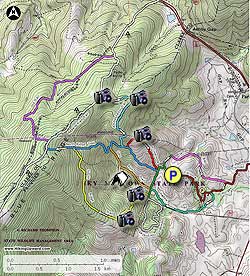
The 7.1 mile circuit hike we describe here takes you through the lower trails and pastures along several creeks, then heads uphill on the South Ridge to the North Ridge Trail and Appalachian Trail (AT). The meadows in this section of the circuit are similar to the high meadows found on Cold Mountain in the southwestern part of Virginia. Finally descend back towards the parking area and pass the Piedmont Overlook, the best vista of the circuit.
Also make sure to check out the many events the park has to offer. From astronomy, to hikes and camp outs, Sky Meadows has something for everyone!
- Mile 0.0 - From the parking area pass the information kiosk on the paved path towards the Park Office. 50ft before the Park Office turn right onto the green blazed continuation of the Boston Mill Road. Follow the trail next to a large field where the trail turns right then terminates where the pink blazed James Ball Trail begins.
- Mile 0.25 - Continue on the James Ball Trails passing a view of one of the valley ponds near Paris, then climb a small rise through the trees and emerge in another field. The trail will now descend before passing through the main picnic area at Sky Meadows Park. The picnic area has many picnic tables and charcoal barbecues that are available on a first come first served basis. The shelter barbecue area needs to be reserved. Stay to the left of the picnic area passing a pine tree stand where the James Ball trail continues on the opposite side of the service road. Continue on the pink blazed James ball Trail for another 0.1 miles where the trail terminates with the brown blazed Corporal Morgan Trail.
- Mile 1.15 - Turn right on the brown blazed Corporal Morgan Trail as it winds around the east end of the large picnic area. Shortly arrive at a Trail Marker and stay left on the brown blazed trail. Cross a small creek then the brown blazed Corporal Morgan Trail turns right, and the tiel blazed Hadow Trail turns left.
- Mile 1.4 - Turn left onto the tiel blazed Hadow Trail passing another large field with views to the east. In 0.2 miles cross the main Sky Meadows Park access road just inside the park entrance. After crossing the road, the Hadow Trail continues along a small stream with another nice bench with views back to Bleak House. Stay on the trail as it gently climbs to the gravel Boston Mill Road where the Hadow Trail ends. (the orange blazed Gap Trail starts on the other side of the road)
- Mile 2.25 - Turn left on the Boston Mill Road for 0.1 miles where the gravel road turns right into a field and continues as the South Ridge Trail. After Turning right stay straight on the gravel road for another 75 yards to the next trail marker at which point the yellow blazed South Ridge Trail turns left uphill. (straight for another 0.3 miles on the gravel road is a camping area, equipped with 12 pad sites)
- Mile 2.4 - Turn left uphill on the yellow blazed South Ridge Trail passing an overlook. In 0.1 miles pass homestead ruins where the trail becomes steeper before arriving at a clearing and another overlook. Continue uphill into a more heavily wooded area on the South Ridge Trail, then in 1.0 miles reach the intersection of the North Ridge trail.
- Mile 4.0 - Turn left uphill on the blue blazed North Ridge Trail for 0.3 miles to the ridge and intersection of the white blazed Appalachian Trail (AT).
- Mile 4.3 - Turn right north on the AT and and pass the intersection of the purple blazed Old Trail. Stay straight on the AT, cross a pipeline clear cut then pass through a livestock gate. The AT will now gently descend to the intersection of the Ambassador Whitehouse Trail and arrive at the mountain meadows.
- Mile 5.1 - Stay right on to the Ambassador Whitehouse Trail as it descends through the meadows, then renters the forest in 0.8 miles. Pass through a wooded area, cross the pipeline clear cut where the trail turns right, then descend steeply for 0.1 miles to the intersection of the North Ridge Trail.
- Mile 6.2 - Turn left on the North Ridge Trail for 75 yards to the intersection of the Piedmont Overlook Trail. Turn left on the Piedmont Overlook Trail for 0.1 miles yards then cross a fence stile into an open field with a panoramic view of the Piedmont Valley. Continue down the trail for the remaining 0.8 miles back to Boston Mill Road, then turn left following the short distance back to Mount Bleak House and the parking area.
- Mile 6.9 - Arrive back a the parking area.