Loading...

🔥 End of Summer sale! 50% off on Supporter Accounts — now through September 1st. Learn More.

Sky Meadows Farms and Lost Mountain Hike

Directions
Map
Pictures
Send to App
Distance:
4.8 Miles / 7.7 km
Type:
Loop
Difficulty:
Easy
Time to Hike:
2 hours, ~24 minutes
Features:
Surface Type:
Dirt
Town:
Paris, Virginia
Directions:
38.99042, -77.946934
Added:
April 03, 2025
Updated:
April 06, 2025
Guide by:
Copy Trail Link Hiking this trail? Send a friend or family member a link to this trail guide for your own safety. Hike at your own risk (disclaimer)
Loading...
Loading...
452'

Total Change
662'

Ascent
661'

Descent

Download the Trail Route for Offline Use

Supporters get exclusive access to download trail routes to the MyHikes app for offline use. Stay prepared on your adventure, even without an internet connection! Become a Supporter today to unlock this feature and hike with confidence.

Send to App

Sky Meadows Farms and Lost Mountain Hike

Sky Meadows Farms/Lost Mountain is the equestrian section in Sky Meadows on the eastern side of VA17. What many people are not aware of is this area of the park is also accessible to hikers, and has over 7 miles of trails that pass ponds, through fields, and has a beautiful westerly overlook on Lost Mountain. Also make sure to check out the many events the park has to offer. From astronomy, to hikes and camp outs, Sky Meadows has something for everyone!

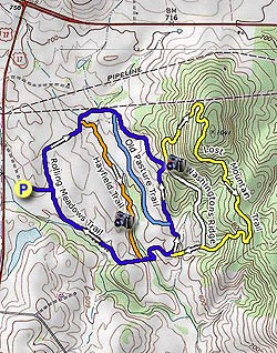
Stop at the kiosk when entering the park and pay the small entrance fee. Parking is located in the area in front of the barns. Please do not park in the top larger lot as these spaces are reserved for horse trailers.

The trails are not blazed, but each intersection is well marked with trail sign posts. The hike directions here are for a 5.2 mile double loop, but as most trails are interconnecting many combinations of hikes can be made.

From the top parking area it's a short walk to the intersection of the Rolling Meadows Trail. Turn left and follow the trail around the fields until reaching the intersection of the Hayfield Trail.

Turn right on the Hayfield Trail where it enters another field and soon follows a stream. Notice a bench across the stream at the midpoint, the bench is located above the migratory duck ponds that are not visible from the Hayfield Trail. The bench is accessible from the Old Pasture Trail.

Turn left where the Hayfield Trail ends at the Rolling Meadows Trail, then shortly cross a small stream. The Rolling Meadows Trail will wind thought the upper meadow before passing the southern end of the Lost Mountain Trail. Continue on the Rolling Meadows Trail, pass the Old Pasture Trail, then arrive at the four way intersection of the Lost Mountain Trail and Washington's Ridge Trail.

There is a bench at the intersection with a great view to the west and main section of the Sky Meadows Park.

Note: The hike now continues uphill on the narrower Lost Mountain Trail. If doing this hike in the fall or winter the trail is unblazed and difficult to follow with leaves on the ground.

Follow the Lost Mountain Trail as it enters the woods climbing the ridge. The trail will enter a utility clear cut for 25 yards before re-entering the woods and following the ridge. Pass through several small gullies then head downhill and passing the intersection of the Washington's Ridge Trail.

Shortly after passing the Washington's Ridge Trail arrive back at the intersection of the Rolling Meadows Trail. Turn left and follow the Rolling Meadows Trail, re-crossing the stream, passing the intersection of the Hayfield Trail, then in 0.6 miles arriving back at the beginning of the loop and connector trail to the parking area.

Explore 55 trails near Paris, VA
  1. Parking

    38.99042, -77.946934
  2. Main Trailhead

    38.990502, -77.945938
No community routes found. To add your own hike as a Community Route for this Trail guide, leave a Trip Report with an attached GPX file.

Hazards

Ticks - Lyme Disease More Info (CDC)
Snakes
Poison Ivy/Oak

Seasons

All

Trip Reports (Reviews)

Rated 3.21 out of 5 based on 14 ratings.
By: Chris C
4.8 miles / 7.7 km
July 29, 2018
Hiked Dec 22, 2017 with my two adult sons and again on July 29, 2018 with my wife. Very different feel between winter and summer. Both times we went counter-clockwise and headed up lost mountian trail and then hung a right back onto rolling meadows. In general, it's a nice meadow hike, cross a creek, a bit more meadow and then you enter tree line and start up to a ridge (with modest amount of elevation gain), then back down for more meadows back to the parking area. In winter, rolling fields were copper colored grass against a gray sky. Summer was very green hills and fields against a blue sky. Sometimes the nice views are not from the top of a mountain. Did get two ticks in July. Spray up before you go. Peach orchards about two miles away were a good find for pick your own after the July hike.
Legacy Review
By: Nice stroll
4.8 miles / 7.7 km
October 28, 2017
We've hiked a number of times across the road at Sky Meadows but opted to try out this area to get away from the crowds on a beautiful fall day. Came across a few people on horseback and gave them leeway to pass they were always pleasant and said hi. We did the entire blue trail and then added the Lost Trail to get up to the ridge. We went counter clockwise, which is the way to go as it got the heart going in some areas but would have been much tougher and steeper coming the other way. Views were pretty much only from the intersection in the middle of the area. Loss of leaves helped with increasing views but it was mostly just a walk in the woods. Would be nice to check out on a hot summer day with full tree cover. Trail is nice and wide so we could walk side by side most the way.
Legacy Review
By: Dan
4.8 miles / 7.7 km
March 20, 2017
This is a very pleasant hike, but the views do not merit a 5. It's more like a 3. That said, meandering through fields, pastures and woods does have its own appeal, and the climb up Lost Mountain will definitely get your heart going. No navigational difficulties on this one. Just be sure to take along a copy of the topographical map and you'll be fine. After completing the hike, reflect on your trek at one of the nearby wineries!
Legacy Review

Weather Forecast

In Paris, VA

Explore Hiking Trails

You May Also Like

New York's Best Waterfalls - Whether you're planning a day hike, roadside stop, or a leisurely short walk, this guide provides hikers, travelers, and locals alike with 63 different locations to over 100 scenic waterfalls to help plan your next adventure!
Explore

New York's Best Waterfalls

Whether you're planning a day hike, roadside stop, or a leisurely short walk, this guide provides hikers, travelers, and locals alike with 63 different locations to over 100 scenic waterfalls to help plan your next adventure!

Read
25 Best Day Hikes in North Carolina - Discover the top 25 best day hikes in North Carolina, from breathtaking waterfalls to mountain peaks. Explore hidden gems, scenic views, and trails suitable for all skill levels, perfect for your next outdoor adventure.
Explore

25 Best Day Hikes in North Carolina

Discover the top 25 best day hikes in North Carolina, from breathtaking waterfalls to mountain peaks. Explore hidden gems, scenic views, and trails suitable for all skill levels, perfect for your next outdoor adventure.

Read

Before you boogie...

Find our trail guides useful? Consider becoming a Supporter to unlock perks!

MyHikes is an indie platform that makes exploring public trails easier for everyone. The platform has no investors, no ads, and is owned and operated by one person, Dave Miller. Dave has personally mapped and written over 1,800 trail guides on MyHikes for the public to explore. MyHikes has helped millions outdoor enthusiasts plan their next adventure.

But it takes a lot of time 🕦, money 💰, work, and espresso shots ☕ to run MyHikes, including hiking , mapping , writing , and publishing new trails with high-quality (accurate) information... along with software engineering (coding) the platform like building new features, website and mobile app development (iOS and Android), site maintainance . and much much more.

Supporters unlock website and mobile app perks with an annual one-time payment of $25 (you renew) 😎👍. Or you can simply make a Donation of your choice. Otherwise, you can support us by telling your friends about MyHikes - both quick and free 🎉

Admin user profile picture

Dave Miller
MyHikes Founder