Silver Run Falls at Tioga State Forest near Wellsboro, Pennsylvania is a difficult and slightly-dangerous 0.6-mile hike that leads upstream to a beautiful 20-foot two-tier waterfall, Silver Run Falls.
Hike Description
This hike is a total bushwhack - there is no trail to follow - and some sections are a bit dangerous, so hikers should come prepared if they want to reach Silver Run Falls.
First, hikers will begin at the parking area, located just east of Silver Run along Landrus Rd and will hike west along the road before hiking down along Silver Run creek. Next, the hike brings you down along Silver Run creek, but you must stay to the right-hand side of the creek - unless you plan to literally hike in the creek upstream. So hikers will want to traverse down and over the concrete structure with the large metal culvert (metal pipe that passes under Landrus Rd) to start your hike upstream along the right-hand side of the creek.
The first 100-feet hiking upstream is likely the sketchiest as there's one steep slope where hikers must use some fallen boulders to keep their balance without falling 5-feet into the creek below. After passing that section, hikers will be directly underneath a 40-foot tall rocky ledge of a gorge, which is dangerous enough as most of the rocks you hike on here have fallen from this rocky gorge ledge. Here, hikers may want to hike in the creek itself to play it safe.
Just beyond the rocky gorge section, hikers will want to stay close to the creek, while passing through rhododendron, to make their way uphill.
Smaller Waterfalls and Cascades
While hiking up Silver Run, hikers will find several small waterfalls and cascades which are no-doubt scenic; however, Silver Run Falls is a lot nicer.
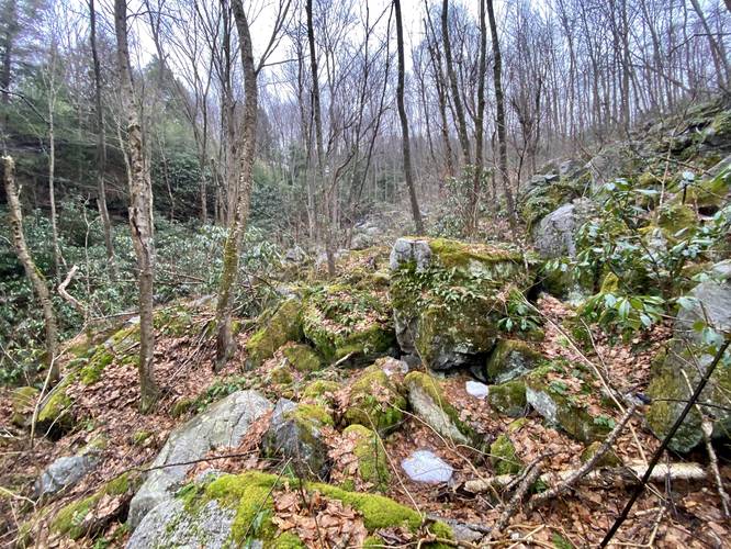
Boulder Field Crossing
After hiking 100-feet or so up the hill from Silver Run, hikers will hit a large boulder field that sits in the way of you and Silver Run Falls. The most dangerous way to hike to the waterfall is directly through this boulder field, so instead I hiked around it to reach the waterfall - as should other hikers. This boulder field is littered with large boulders of various sizes where you could easily break an ankle or leg, or easily find some Timber Rattlesnakes hanging out in the holes below.
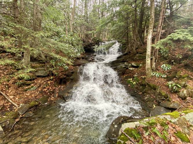
Silver Run Falls
Finally, after hiking around the boulder field, hikers will reach the mid-way point in the two-tier waterfall. All you need to do is carefully traverse boulders over to the creek to a beautiful viewing point just downstream at the base of the waterfall. Silver Run Falls is about 20-feet tall in total, but is broken up in a two-tiered waterfall.
Hiking Out
Follow the way you came in, and assuming you followed these directions - it should not be a difficult hike out, but takes close to 15 minutes to carefully make your way back to parking.
Parking
Hikers will find a parking turnout along Landrus Road about 0.1-miles east of Silver Run.
Pets
Dogs should probably stay at home for this hike, but are permitted.
Timber Rattlesnakes
This area of forest is likely home to the Timber Rattlesnake, especially in the rocky boulder fields. Please be aware of their presence and give them space. They're usually active from late April through late September.
Hike Description
This hike is a total bushwhack - there is no trail to follow - and some sections are a bit dangerous, so hikers should come prepared if they want to reach Silver Run Falls.
First, hikers will begin at the parking area, located just east of Silver Run along Landrus Rd and will hike west along the road before hiking down along Silver Run creek. Next, the hike brings you down along Silver Run creek, but you must stay to the right-hand side of the creek - unless you plan to literally hike in the creek upstream. So hikers will want to traverse down and over the concrete structure with the large metal culvert (metal pipe that passes under Landrus Rd) to start your hike upstream along the right-hand side of the creek.
The first 100-feet hiking upstream is likely the sketchiest as there's one steep slope where hikers must use some fallen boulders to keep their balance without falling 5-feet into the creek below. After passing that section, hikers will be directly underneath a 40-foot tall rocky ledge of a gorge, which is dangerous enough as most of the rocks you hike on here have fallen from this rocky gorge ledge. Here, hikers may want to hike in the creek itself to play it safe.
Just beyond the rocky gorge section, hikers will want to stay close to the creek, while passing through rhododendron, to make their way uphill.
Smaller Waterfalls and Cascades
While hiking up Silver Run, hikers will find several small waterfalls and cascades which are no-doubt scenic; however, Silver Run Falls is a lot nicer.
Boulder Field Crossing
After hiking 100-feet or so up the hill from Silver Run, hikers will hit a large boulder field that sits in the way of you and Silver Run Falls. The most dangerous way to hike to the waterfall is directly through this boulder field, so instead I hiked around it to reach the waterfall - as should other hikers. This boulder field is littered with large boulders of various sizes where you could easily break an ankle or leg, or easily find some Timber Rattlesnakes hanging out in the holes below.
Silver Run Falls
Finally, after hiking around the boulder field, hikers will reach the mid-way point in the two-tier waterfall. All you need to do is carefully traverse boulders over to the creek to a beautiful viewing point just downstream at the base of the waterfall. Silver Run Falls is about 20-feet tall in total, but is broken up in a two-tiered waterfall.
Hiking Out
Follow the way you came in, and assuming you followed these directions - it should not be a difficult hike out, but takes close to 15 minutes to carefully make your way back to parking.
Parking
Hikers will find a parking turnout along Landrus Road about 0.1-miles east of Silver Run.
Pets
Dogs should probably stay at home for this hike, but are permitted.
Timber Rattlesnakes
This area of forest is likely home to the Timber Rattlesnake, especially in the rocky boulder fields. Please be aware of their presence and give them space. They're usually active from late April through late September.