Loading...

WINTER SALE! 50% OFF Supporter Accounts — now through January 31st. Learn More.

School House Ridge Hike

Part of the Harpers Ferry National Historic Park, School House Ridge was a Confederate held position during the Battle of Harpers Ferry in September of 1862. The hiking trails have multiple views to the northwest of the Harpers Ferry area, including a walk along Flowing Springs Run, past Homestead Ruins and replica Confederate cannon along the Confederate line. This is an easy walk with well maintained trails, and offers considerably more solitude than the Loudoun Heights and Maryland Heights hikes also located in the Harpers Ferry National Historic Park.

Battle of Harpers Ferry - September 12-15, 1862

As Robert E. Lee advanced into Maryland with the Army of Northern Virginia, he ordered Thomas Jonathan 'Stonewall' Jackson to capture the garrison at Harpers Ferry to secure a supply line back to Virginia. Jackson's troops located on School House Ridge were under the command of A.P. Hill, Lawton, and J.R. Jones. McLaws commanded on Maryland Heights, and Walker and Crutchfield on Loudoun Heights. The first day of fighting saw heavy cannon fire but not advancement by the Confederate forces on Harpers Ferry. To press the battle after a second day of fighting Jackson ordered A.P. Hill to flank Miles's Union troops to the south of their location on Bolivar Heights. That night A.P. Hill moved into position next to the Shenandoah River with 3,500 troops and 20 cannon.

After heavy bombardment on the third day by the Confederate troops Union Col. Dixon S. Miles realized the fight was hopeless and surrendered to Jackson's forces, but died of wounds from Cannon fire before the surrender took affect. Although by Civil War standards the loss of life was considerably fewer, with 44 Union troops and 39 Confederate troops killed, the battle saw the largest surrender of Union troops in one engagement with 12,000 becoming prisoners of war.

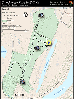
Battle of Harpers Ferry Battlefield Map (3 pages)

  • Main Eastern Fields - Wide fields with picket fences on the easterly flanks
  • Allstadt Trail - 360 vista to the northwest and Harpers Ferry from A.P. Hill's original position
  • Homestead Ruins - 360° Ruins of an 1800's homestead in the middle of the park
  • Allstadt Trail Loop - Flowing Springs Run as it flows next to the trail
  • Courtney's Battery Trail - View towards Harpers Ferry from the northerly section of School House Ridge and the position of J.R. Jones
  • School House Ridge - New connection trail between the Allstadt Trail and the Battery Trail
  • Battlefield Information - Informational signage from the National Park Service for the Battle of Harpers Ferry
Explore 32 trails near Millville, WV

Know Before You Go

  • School House Ridge offers an easy 3.2-mile hike within Harpers Ferry National Historic Park with historical significance as a Confederate position during the Battle of Harpers Ferry.
  • The trail features views of Harpers Ferry, access to Flowing Springs Run, Homestead Ruins, and replica Confederate cannons, providing a blend of natural beauty and Civil War history.
  • Compared to other nearby hikes, School House Ridge offers a more secluded experience while exploring key sites related to A.P. Hill's Confederate troops during the Battle of Harpers Ferry.
Interactive topographic map for School House Ridge Hike located in Millville, WV. Click the "View Map" button to load GPS coordinates and trail markers.
Get directions
Distance
3.2 mi
Difficulty
Easy
Type
Out-and-Back
Est. Time
1.6 hrs
Elev. Gain
224'
Rating
3.5
Added
March 20, 2025
Updated
April 06, 2025

Weather Forecast

Loading...
Total Change
116'
Ascent
224'
Descent
223'
Loading...

Download the GPX Data for Offline Use

Supporters get exclusive access to download trail routes to the MyHikes app for offline use. Stay prepared on your adventure, even without an internet connection! Become a Supporter today to unlock this feature and hike with confidence.

Download School House Ridge Hike GPX Data to the MyHikes Mobile App

Features

Vista / Lookout Point
Dogs
Water Source

Points of interest

  1. Parking

    39.307783, -77.777623
  2. Main Trailhead

    39.308101, -77.778268

Safety information

For your own safety: plan ahead, let someone know where you'll be, and hike at your own risk.

Availability

All seasons

Surface type

Dirt

Trip Reports (Reviews)

Rated 3.5 out of 5 based on 2 ratings.

Ready to help fellow hikers? Add a trip report to share your experience and provide valuable insights for other hikers!

By: Hobo Hiker
3.2 miles / 5.1 km
November 25, 2017
This is your typical battlefield hike. A walk in an open field with some Civil War fences and a couple of cannons. If you are into the battle of Harper's Ferry than I would say this is a must to visit because you can see the view Jackson had of Maryland and Loudoun Heights. Mostly the people here are friendly locals out walking their dogs in the field. The parking lot was a little farther down Millvill Rd than where my GPS said. Just keep going on Millvill Rd until you see a big "School House Ridge Park" sign.There are big red signs in the parking lot that clearly say don't try parking at the lot and trespassing across the road at the quarry. It says they will tow your car from the parking lot if they catch you trespassing. There must of been a problem with people swimming in the nearby quarry. The lot is also part of Harper's Ferry national park so technically you should pay the entrance fee for Harper's Ferry park before using the lot. I just parked and risk it with no problems, but usually the Harper's Ferry area is heavily patrolled by park rangers.
Legacy Review
By: Pete
3.2 miles / 5.1 km
July 04, 2017
Happy 4th! I decided to hike here because Ive always driven past here on my way to either Maryland or Loudoun Heights. I wasn't expecting much, but suprisingly this hike is pretty good. This is a great hike for people with knee or ankle issues. The first part of the hike is all grass. The second part is almost all supple wood chips. It's very easy on the joints. This is one of those hikes that even though you are really next to route 340 it doesn't feel like it. It's really pretty quiet and not heavily used. There are quite a few decent/good views on the hike, especially on the way out. If you're up for it, wineberries (wild raspberries) are all over the place. This hike was quite nice, and I was suprised at the amount of solitude I got when you cant even park at Maryland or Loudoun Heigts most july 4th holidays. I recommend it. It's worth your time.
Legacy Review
No community routes found. To add your own hike as a Community Route for this Trail guide, leave a Trip Report with an attached GPX file.

Popular categories

Scenic mountain view representing vista trails
Vista trails
Scenic gorge of cascades representing waterfall trails
Waterfall hikes
Rugged mountain terrain representing summit trails
Summit trails
Scenic mountain view representing dog-friendly trails
Dog-friendly
Scenic campsite with a view representing camping trails
Camping trails
Appalachian Trail logo representing A.T. hikes
A.T. hikes

You May Also Like

Colorado's Million Dollar Highway - Plan a day's drive adventure along the iconic Million Dollar Highway in Colorado. Explore the best short trails, roadside stops, waterfalls, vistas, ghost towns, and hot springs within a ~6 hour road trip.
Explore

Colorado's Million Dollar Highway

Plan a day's drive adventure along the iconic Million Dollar Highway in Colorado. Explore the best short trails, roadside stops, waterfalls, vistas, ghost towns, and hot springs within a ~6 hour road trip.

Read
🍪 We use cookies to learn about site usage and to serve map tiles. You may block cookies manually in the browser. By continuing you agree. Learn more