-
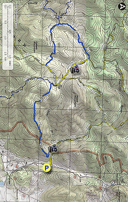
Mile 0.0 - Park along Woodward Rd/VA 600 opposite Hungry Horse Ln. DO NOT drive up Hungry Horse Ln. This is a private driveway and open to resident cars and hikers only. Please respect private property. From the parking area pass the gate and walk up Hungry Horse Ln. Pass a house on the left then the Virginia Farm Bureau on the right before the road makes a hairpin turn to the left. Continue on the road for 50 yards where the Hazel River Trail starts.
-
Mile 0.3 - Turn right along the yellow blazed Hazel River Trail with Hazel River on your right for 250 yards to the intersection of the Sam's Ridge Trail.
-
Mile 0.41 - Turn left onto the blue blazed Sam's Ridge Trail. After the first 0.4 miles the trail becomes increasingly steeper without the aid of switchbacks. Pass several areas of Mountain Laurel that bloom in early June, then the trail begins to level out near the saddle ending at the intersection with the blue blazed Broad Hollow Trail.
-
Mile 2.72 - Turn right onto the blue blazed Broad Hollow Trail for 0.2 miles crossing Sams Run then arriving at the intersection of the Hazel Mountain Trail where the Broad Hollow Trail ends.
-
Mile - 2.92 - Turn right on the yellow blazed Hazel Mountain Trail where it gradually descends into the hollow through old growth forest with a small stream on the left. Pass the top terminus of the Hazel River trail on your right and continue downhill on the Hazel Mountain Trail. Cross two streams that feed Hazel River and reach the intersection of the Catlett Spur Trail.
-
Mile 3.88 - Turn left onto the blue blazed Catlett Spur Trail gradually climbing for the first 0.3 miles then recrossing the stream. From this point the Catlett Spur Trail becomes steeper for the remaining 0.9 miles to the intersection of the Catlett Mountain Trail.
-
Mile 5.08 - Turn left on the blue blazed Catlett Mountain Trail descending through a hollow and passing a sink hole created by the porous limestone collapsing within the mountain. The trail gets steeper then crosses a small stream. Pass over a small knoll and follow the trail to the Hazel Mountain Trail intersection where the Catlett Mountain Trail ends.
-
Mile 6.21 - Turn left onto the yellow blazed Hazel Mountain Trail and pass over a the trail high point arriving back at the intersection of the Broad Hollow Trail where the loop section of the hike began.
-
Mile 6.7 - Turn right onto the Broad Hollow Trail for 0.2 miles back to the intersection if the Sams Ridge Trail.
-
Mile 6.9 - Turn left downhill on the steep descent down Sams Ridge to the valley and intersection with the Hazel River Trail.
-
Mile 9.21 - Turn right on the Hazel River Trail for 250 yards to the Hazel River Trail terminus and Hungry Horse Ln.
-
Mile 9.22 - Turn left on paved Hungry Horse Ln. for 0.3 miles back to the parking area on Woodward Rd/VA600.
-
Mile 9.52 - Arrive back at the parking area on Woodward Rd/VA600.
Sams Ridge and Catlett Spur Hike
Know Before You Go
- Distance
- 8.2 mi
- Difficulty
- Hard
- Type
- Loop
- Est. Time
- 4.1 hrs
- Elev. Gain
- 2,322'
- Rating
- 3.7
- Added
- March 19, 2025
- Updated
- April 06, 2025
Weather Forecast
Don't let Google decide who you trust.


<strong>Trail map and elevation chart not rendering in print mode?</strong> Simply scroll to the trail map section, then try printing again!
529 m
708 m
708 m
Features
- Dogs
- Camping
- Water Source
Points of interest
-
Parking
38.614334, -78.256467 -
Main Trailhead
38.614334, -78.256467
Safety information
For your own safety: plan ahead, let someone know where you'll be, and hike at your own risk.
Hazards
Availability
Surface type
Trip Reports (Reviews)
Ready to help fellow hikers? Add a trip report to share your experience!


You may also like

25 Best Day Hikes in Virginia
Explore the top hikes in Virginia, from iconic trails in Shenandoah National Park to hidden gems in the Blue Ridge Mountains. Find your next unforgettable outdoor adventure.

25 Best Day Hikes in West Virginia
Discover 25 of the best day hikes in West Virginia, from scenic overlooks to wilderness trails—perfect for every level of hiker.

25 Best Day Hikes in North Carolina
Discover the top 25 best day hikes in North Carolina, from breathtaking waterfalls to mountain peaks. Explore hidden gems, scenic views, and trails suitable for all skill levels, perfect for your next outdoor adventure.

Best of the Alps: Hiking, Adventure & Scenery
Plan your ultimate European Alps adventure! Discover the best hiking trails, epic scenery, and villages in the Swiss Alps, Dolomites, Chamonix, and Lake Como.

