Loading...

๐ŸŽ‰ Enjoy a Free 7-Day Supporter Trial and Unlock Exclusive Perks โ€” No Credit Card Required. Learn more.

Royal Queens Park Trail

Directions
Map
Pictures
Send to App
Distance:
0.3 km / 0.2 Miles
Type:
One-Way
Difficulty:
Easy
Time to Hike:
~6 minutes
Features:
Surface Type:
Universal Access
Town:
Niagara-on-the-Lake, Ontario - Canada
Directions:
43.25779, -79.069891
Added:
August 11, 2024
Updated:
August 23, 2024
Copy Trail Link Hiking this trail? Send a friend or family member a link to this trail guide for your own safety. Hike at your own risk (disclaimer)
Loading...
Loading...
7m

Total Change
7m

Ascent
7m

Descent

Download the Trail Route for Offline Use

Supporters get exclusive access to download trail routes to the MyHikes app for offline use. Stay prepared on your adventure, even without an internet connection! Become a Supporter today to unlock this feature and hike with confidence.

Send to App

Royal Queens Park Trail

The Royal Queens Park Trail in Niagara-on-the-Lake, Ontario is an easy 0.3 km trail that runs along the lakefront at Royal Queens Park and features views of Lake Ontario, Old Fort Niagara (in the USA), and Toronto on the horizon.

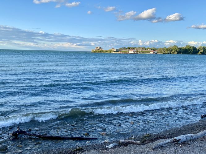
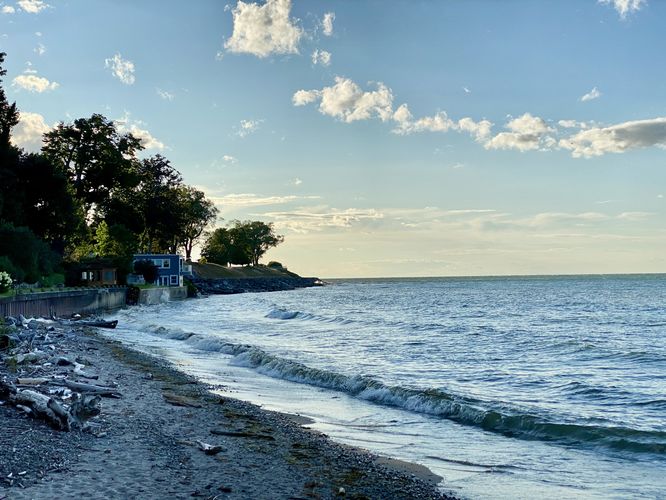
This short trail can be found on either end of Royal Queens Park, but this one-way route begins on the east side of the park along King Street. The trail follows a paved pathway as it leading downhill as it passes a scenic gazebo before reaching the shoreline of Lake Ontario. The trail runs along the water's edge with views along the way before it leads back uphill into the wooded park. At the western end of the shoreline section is a nice view of the lake toward Fort Mississauga.

The trail ends along Front Street North for a short 0.3 km walk.

Universal Access
This paved trail is universally-accessible for most of the route. Starting on the eastern-end of the trail, visitors will find a universally-accessible path that connects to the sidewalk along King Street. This paved, smooth path, leads downhill and runs along the shoreline following a mostly-flat surface along concrete pavers. The western side of the trail, where it ascends back into the park, is steeper and follows a hardened dirt surface. For this reason, this trail should be considered mostly universally-accessible but not fully accessible as of August 2024.

Parking
Visitors will find a large parking lot in the middle of the park, located off of Front Street N in Niagara-on-the-Lake, ON.

Pets
Dogs are allowed only if leashed and must be cleaned up after.
Explore 8 trails near Niagara-on-the-Lake, ON
  1. Parking

    43.25779, -79.069891
  2. Main Trailhead

    43.257396, -79.068635
  3. View of Old Fort Niagara as seen from Royal Queens Park

    43.257872, -79.068772
    View of Old Fort Niagara as seen from Royal Queens Park
  4. View of Lake Ontario

    43.258892, -79.070703
    View of Lake Ontario
No community routes found. To add your own hike as a Community Route for this Trail guide, leave a Trip Report with an attached GPX file.

Seasons

All

Photo Albums

Trip Reports

Trail Guide By:
Admin user profile picture
0.2 miles / 0.3 km
0.2 miles / 0.3 km
August 11, 2024
Hiking

Weather Forecast

In Niagara-on-the-Lake, ON

Explore Hiking Trails

You May Also Like

Colorado's Million Dollar Highway - Plan a day's drive adventure along the iconic Million Dollar Highway in Colorado. Explore the best short trails, roadside stops, waterfalls, vistas, ghost towns, and hot springs within a ~6 hour road trip.
Explore

Colorado's Million Dollar Highway

Plan a day's drive adventure along the iconic Million Dollar Highway in Colorado. Explore the best short trails, roadside stops, waterfalls, vistas, ghost towns, and hot springs within a ~6 hour road trip.

Read
Glacier's Going-to-the-Sun Road - Discover the breathtaking beauty of Glacier National Park along the iconic Going-to-the-Sun Road. From stunning roadside stops to picturesque waterfalls and vistas, this engineering marvel offers endless opportunities for exploration.
Explore

Glacier's Going-to-the-Sun Road

Discover the breathtaking beauty of Glacier National Park along the iconic Going-to-the-Sun Road. From stunning roadside stops to picturesque waterfalls and vistas, this engineering marvel offers endless opportunities for exploration.

Read
New York's Best Waterfalls - Whether you're planning a day hike, roadside stop, or a leisurely short walk, this guide provides hikers, travelers, and locals alike with 63 different locations to over 100 scenic waterfalls to help plan your next adventure!
Explore

New York's Best Waterfalls

Whether you're planning a day hike, roadside stop, or a leisurely short walk, this guide provides hikers, travelers, and locals alike with 63 different locations to over 100 scenic waterfalls to help plan your next adventure!

Read

Before you boogie...

Find our trail guides useful? Consider becoming a Supporter to unlock perks!

MyHikes is an indie platform that makes exploring public trails easier for everyone. The platform has no investors, no ads, and is owned and operated by one person, Dave Miller. Dave has personally mapped and written over 1,800 trail guides on MyHikes for the public to explore. MyHikes has helped millions outdoor enthusiasts plan their next adventure.

But it takes a lot of time ๐Ÿ•ฆ, money ๐Ÿ’ฐ, work, and espresso shots โ˜• to run MyHikes, including hiking , mapping , writing , and publishing new trails with high-quality (accurate) information... along with software engineering (coding) the platform like building new features, website and mobile app development (iOS and Android), site maintainance . and much much more.

Supporters unlock website and mobile app perks with an annual one-time payment of $25 (you renew) ๐Ÿ˜Ž๐Ÿ‘. Or you can simply make a Donation of your choice. Otherwise, you can support us by telling your friends about MyHikes - both quick and free ๐ŸŽ‰

Admin user profile picture

Dave Miller
MyHikes Founder