The Fort Mississauga Trail in Niagara-on-the-Lake, Ontario is an easy 1.3 km out-and-back trail that leads to the old military fort, Fort Mississauga, and features views of Lake Ontario with Toronto on the horizon.
Trail
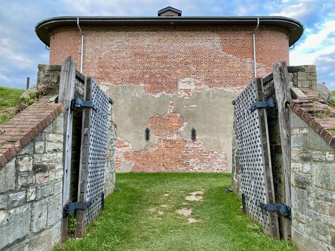
This trail begins on the eastern edge of the Niagara-on-the-Lake Golf Course along Simcoe Street. The smooth dirt trail runs adjacent to Simcoe Street's sidewalk before veering off into the golf course, toward the old fort. You'll reach the Fort Mississauga after the trail leads around a bend, around 0.4 km from the trailhead. Here, you can walk around the fort up-close if you wish or you can follow this route for several different perspectives.
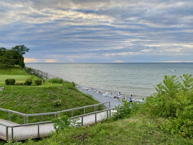
If you follow the route provided, it leads around large embankments adjacent to the fort, which were built as earthwork barriers to defend against attacks. As of August 2024, the trail included a boardwalk that leads around these earthworks to reach a beautiful view of Lake Ontario. During clear days, you can see Toronto sitting on the horizon across the lake. The trail reaches a junction with a crushed gravel pathway that runs along the lakefront, which appears to be very new as of August 2024. This crushed gravel path is likely where the universally-accessible portion of the trail ends. If you continue onward along this route, it leads east before leading up a fairly steep hillside along an unmarked pathway that runs atop the earthwork embankments. From these embankments, you'll get different views of the fort and Lake Ontario. If you follow the top of the embankments back to the fort's front gates, you'll find a path that connects the loop right at the gate. After exploring the fort, you'll take the same path back to the trailhead for a short 1.3 km out-and-back walk.
Universal Access
This trail is partially universally-accessible from the trailhead to the crushed gravel path that runs along the shore of Lake Ontario. So visitors that need universal access can appreciate the fort from the trail. The shoreline trail should be considered universally-accessible as well, but the path that runs along the embankment around the fort is not accessible.
Parking
Visitors will find street parking along Simcoe Street or you can park at the golf course parking lot at the coordinates provided. Note that if you park near or at the golf course, you do so at your own risk.
Pets
Dogs are allowed only if leashed and must be cleaned up after.
Warning
Active golf course: Visitors walk (and park) at their own risk along this trail as you may be walking through an active golf course depending on the time of day you visit.
Trail
This trail begins on the eastern edge of the Niagara-on-the-Lake Golf Course along Simcoe Street. The smooth dirt trail runs adjacent to Simcoe Street's sidewalk before veering off into the golf course, toward the old fort. You'll reach the Fort Mississauga after the trail leads around a bend, around 0.4 km from the trailhead. Here, you can walk around the fort up-close if you wish or you can follow this route for several different perspectives.
If you follow the route provided, it leads around large embankments adjacent to the fort, which were built as earthwork barriers to defend against attacks. As of August 2024, the trail included a boardwalk that leads around these earthworks to reach a beautiful view of Lake Ontario. During clear days, you can see Toronto sitting on the horizon across the lake. The trail reaches a junction with a crushed gravel pathway that runs along the lakefront, which appears to be very new as of August 2024. This crushed gravel path is likely where the universally-accessible portion of the trail ends. If you continue onward along this route, it leads east before leading up a fairly steep hillside along an unmarked pathway that runs atop the earthwork embankments. From these embankments, you'll get different views of the fort and Lake Ontario. If you follow the top of the embankments back to the fort's front gates, you'll find a path that connects the loop right at the gate. After exploring the fort, you'll take the same path back to the trailhead for a short 1.3 km out-and-back walk.
Universal Access
This trail is partially universally-accessible from the trailhead to the crushed gravel path that runs along the shore of Lake Ontario. So visitors that need universal access can appreciate the fort from the trail. The shoreline trail should be considered universally-accessible as well, but the path that runs along the embankment around the fort is not accessible.
Parking
Visitors will find street parking along Simcoe Street or you can park at the golf course parking lot at the coordinates provided. Note that if you park near or at the golf course, you do so at your own risk.
Pets
Dogs are allowed only if leashed and must be cleaned up after.
Warning
Active golf course: Visitors walk (and park) at their own risk along this trail as you may be walking through an active golf course depending on the time of day you visit.