-
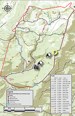
Mile 0.0 – From the parking area on FR 75 pass the information kiosk and start down the Fisher Spring Run Trail (510). The trails in Dolly Sods are not blazed, as such following the trails in the late fall and early spring can be more challenging with leaves on the trail. For the first 0.5 miles the trail passes through an area of fern and younger growth. Soon after the fern area the trail will become more wet, but still nowhere near as wet and boggy as the northern areas in Dolly Sods. Cross a feeder stream for Fisher Spring Run.
-
Mile 0.7 - Pass the first of two good camping sites. This would be great spot if you make a later start or are looking for a site with a good water source. From the campsite the trail will pass through large areas of Rhododendron as Fisher Spring Run comes in from the right. Look for a small gap in the Rhododendron that leads down to Fisher Spring Run and small pool.
-
Mile 1.25 - Arrive at the intersection of the Rohrbaugh Trail (508), the Fisher Spring Run Trail continues to the right. Turn left on the Rohrbaugh Trail. Pass through a nice area of spruce then descend to another feeder stream for Fisher Spring Run. This stream is much larger than the first you crossed at mile 0.7. There is a small pool here, and looking upstream there several small waterfalls. The trail continues up the other bank and passes interesting rock forms before arriving at the next intersection.
-
Mile 1.8 - Reach the intersection of the Wildlife Trail (560) and old forestry road. The Wildlife Trail is to the left and the Rohrbaugh Trail goes right. Stay right remaining on the Rohrbaugh Trail where it becomes wider.
-
Mile 2.15 - Pass through a clearing with high grasses, then cross a very small stream. If you camp at the overlook this is the closest water source. Continue along the trail for a short distance to the first of the overlooks.
-
Mile 2.45 - Reach the smaller of the two overlooks. This is a minor viewpoint but has the best view of the Lions Head promontory on the other side of the valley. Behind the overlook on the other side of the trail is a large campsite suitable for a couple of tents. Continue on the trail for another 0.15 miles.
-
Mile 2.6 - Arrive at the main Rohrbaugh Cliffs overlook. From here there are expansive views of the Red Creek basin, Lions Head, as well as the cliffs further along the Rohrbaugh Trail. This is the turn around point for the hike. Retrace your route back to the Fisher Spring Run trailhead and parking area on FR 75.
-
Mile 4.6 - Arrive back at the trailhead parking area.
Rohrbaugh Cliffs Hike
Know Before You Go
- Distance
- 4.6 mi
- Difficulty
- Easy
- Type
- Out-and-Back
- Est. Time
- 2.3 hrs
- Elev. Gain
- 821'
- Rating
- 0.0
- Added
- March 18, 2025
- Updated
- April 05, 2025
Weather Forecast
Don't let Google decide who you trust.


<strong>Trail map and elevation chart not rendering in print mode?</strong> Simply scroll to the trail map section, then try printing again!
157 m
250 m
250 m
Features
Points of interest
-
Parking
39.006741, -79.327589 -
Main Trailhead
39.006741, -79.327589
Safety information
For your own safety: plan ahead, let someone know where you'll be, and hike at your own risk.
Hazards
Availability
Surface type
Trip Reports (Reviews)
Ready to help fellow hikers? Add a trip report to share your experience!


You may also like

25 Best Day Hikes in West Virginia
Discover 25 of the best day hikes in West Virginia, from scenic overlooks to wilderness trails—perfect for every level of hiker.

25 Best Day Hikes in Virginia
Explore the top hikes in Virginia, from iconic trails in Shenandoah National Park to hidden gems in the Blue Ridge Mountains. Find your next unforgettable outdoor adventure.

Best of the Alps: Hiking, Adventure & Scenery
Plan your ultimate European Alps adventure! Discover the best hiking trails, epic scenery, and villages in the Swiss Alps, Dolomites, Chamonix, and Lake Como.

Colorado's Million Dollar Highway
Plan a day's drive adventure along the iconic Million Dollar Highway in Colorado. Explore the best short trails, roadside stops, waterfalls, vistas, ghost towns, and hot springs within a ~6 hour road trip.

