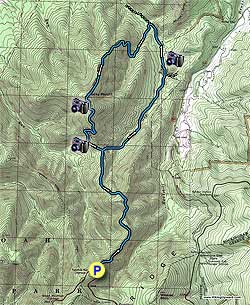
From the concrete post marking the Rocky Mount Trail head on Skyline Drive, 200 yards before Twomile Run Overlook, start down the blue blazed Rocky Mount Trail as it descends along the ridge. Views of Massanutten Peak to the west are visible along this section of the trail. Massanutten Peak marks the southern tip of the 45 mile long Massanutten Range.
The Rocky Mount Trail will level out, then follow the ridge on its west side, pass through a small gap, then climb on its north side before descending steeply to the intersection of the Gap Run Trail 2.2 miles from Skyline Drive. At this point the Rocky Mount Trail you had been following heads back uphill.
Turn right downhill onto the Gap Run Trail. The trail initially descends steeply before crossing Gap Run in 1.9 miles. In another 0.4 miles arrive at a concrete post trail marker. Turn left remaining on the Gap Run Trail. The overgrown road to the right is private property. In 0.4 miles from the concrete post there is a large camping area on the bank of Gap Run. Continue along the trail for another 0.2 miles and arrive at the Rocky Mount Trail junction.
Turn left onto the blue blazed Rocky Mount Trail, cross Gap Run, and in 0.5 miles the trail makes a switchback to the right. At this point the trail begins the steep climb the 1.6 miles up to the Rocky Mount summit.
One hundred yards past the summit is a rock outcrop and the best views on the hike. Continue following the trail as is now descends Rocky Mount. Twomile Run Overlook, and the hike start point, is visible to the south halfway down the mountain.
In 1.3 miles from the summit arrive back at the junction of the Gap Run Trail you descended earlier. Continue straight on the Rocky Mount Gap Trail, as it now heads uphill, retracing your route the 2.2 miles back to Skyline Drive and hike start point.