The Roadside Ruin Trail at Canyonlands National Park near Moab, Utah is an easy 0.3-mile loop hike that features an ancient Native American structure.
Hike Description
This very short hike begins along the Needles Main Park Road (main entrance road to Canyonland's Needles District) and heads in along the main trailhead heading in a counter-clockwise direction. The trail itself is easy to follow with minimal tripping hazards and follows a defined path that heads downhill and then up a short spur trail to reach the roadside ruins.
Ancient Roadside Ruins - Mile 0.14
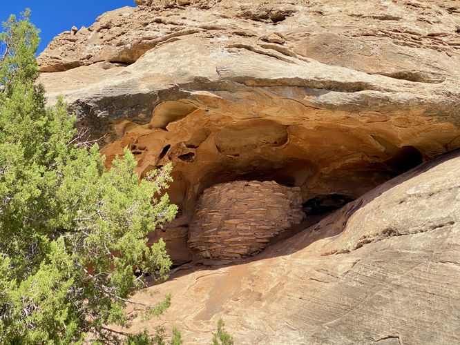
Around mile 0.14, hikers will reach the ancient Native American ruins that sit under a large cave overhang. This natural rock overhang has protected this ancient ruin for nearly 700-years or so, allowing visitors to take a glance at what ancient indigenous people's used to preserve or store food to help survive the harsh desert heat and sun. Please do not climb up to or touch these ancient ruins.
After visiting the ruins, hikers will head out along the loop path following an easy uphill ascent to reach parking.
History
Indigenous people long survived here through hard work and ingenuity. Nearly 700 years ago, some built these small structures, possibly to use for storage or ceremonial purposes. In Canyonlands, even older structures still stand, but archeologists have found few villages. This suggest that early inhabitants farmed intensively, yet may have lived here only seasonlly. Without human impact, these masonry structures can survive for centuries in the desert climate. Please help protect these places by not climbing u to or entering structures. Any contact can erode foundations and weaken walls.
Parking
Hikers will find a parking turnout at the coordinates provided. The turnout is large enough to fit less than 10 cars max.
Pets
Dogs are not allowed on any trails at Canyonlands National Park. Please do not bring your dog here.
Warning
Sun exposure: This trail has very little shade and no water sources. Pack-in all water and wear sun screen and a hat to protect against sun exposure. It's smart to hike either in the early morning or late afternoon to avoid the intense desert sun.
Lack of water: Hikers must pack-in all water as there are no potable or filterable water sources along this trail. Rule of thumb in the desert is to pack-in 1 gallon of water per person per day.
Rattlesnakes: This is rattlesnake territory, so be on the lookout and give any rattlers you find plenty of space.
Fees
Vehicle entry fees to Canyonlands National Park is $30 as of September 2023.
Hike Description
This very short hike begins along the Needles Main Park Road (main entrance road to Canyonland's Needles District) and heads in along the main trailhead heading in a counter-clockwise direction. The trail itself is easy to follow with minimal tripping hazards and follows a defined path that heads downhill and then up a short spur trail to reach the roadside ruins.
Ancient Roadside Ruins - Mile 0.14
Around mile 0.14, hikers will reach the ancient Native American ruins that sit under a large cave overhang. This natural rock overhang has protected this ancient ruin for nearly 700-years or so, allowing visitors to take a glance at what ancient indigenous people's used to preserve or store food to help survive the harsh desert heat and sun. Please do not climb up to or touch these ancient ruins.
After visiting the ruins, hikers will head out along the loop path following an easy uphill ascent to reach parking.
History
Indigenous people long survived here through hard work and ingenuity. Nearly 700 years ago, some built these small structures, possibly to use for storage or ceremonial purposes. In Canyonlands, even older structures still stand, but archeologists have found few villages. This suggest that early inhabitants farmed intensively, yet may have lived here only seasonlly. Without human impact, these masonry structures can survive for centuries in the desert climate. Please help protect these places by not climbing u to or entering structures. Any contact can erode foundations and weaken walls.
Parking
Hikers will find a parking turnout at the coordinates provided. The turnout is large enough to fit less than 10 cars max.
Pets
Dogs are not allowed on any trails at Canyonlands National Park. Please do not bring your dog here.
Warning
Sun exposure: This trail has very little shade and no water sources. Pack-in all water and wear sun screen and a hat to protect against sun exposure. It's smart to hike either in the early morning or late afternoon to avoid the intense desert sun.
Lack of water: Hikers must pack-in all water as there are no potable or filterable water sources along this trail. Rule of thumb in the desert is to pack-in 1 gallon of water per person per day.
Rattlesnakes: This is rattlesnake territory, so be on the lookout and give any rattlers you find plenty of space.
Fees
Vehicle entry fees to Canyonlands National Park is $30 as of September 2023.