Loading...

WINTER SALE! 50% OFF Supporter Accounts — now through January 31st. Learn More.

Riverbend Park Hike

With Scott's Run Nature Preserve and Difficult Run, Riverbend Park along the banks of the Potomac River and just outside the beltway, is the least well known of the three. With only a small amount total elevation gain, the interconnecting trails are suitable for just about any skill and fitness level.

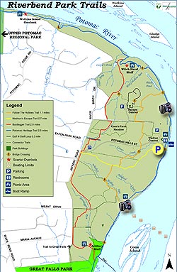
The hiking trails at Riverbend Park can be done in a number of different combinations to suit the abilities of any hiker. Here we have marked out the longest possible circuit route of 4.5 miles.

From the parking area, directly behind the main visitors center, walk through the picnic area, and head upstream on the Potomac Heritage Trail that follows the banks of the Potomac River.

In 0.5 miles pass the Follow The Hollows Trail, and in another 0.2 miles cross another small footbridge then arrive at the intersection of the Bootleger Trail.

The Bootlegger Trail will head uphill on a wider gravel path for a short distance before passing a pond on the right.

Continue uphill for 0.2 miles where the Bootlegger Trail passes a connector trail that heads over to the Duff N Stuff loop trail.

Continue on the Bootlegger Trail for another 0.2 miles where the trail passes through the Conn's Farm Meadow area. From this point the trail runs along the western edge of the park.

1.4 miles after passing through the Conn's Meadow Farm area on the Bootlegger Trail, the Bootlegger Trail will turn left downhill at the intersection of the Great Falls Park connector trail.

Turn left downhill for 0.2 miles passing the Artillery Bluff overlook and arrive at the Potomac Heritage Trail and Potomac River.

At the banks of the Potomac River turn left upstream on the Potomac Heritage Trail. In 0.6 miles pass the Follow The Hollows Trail, then pass through a picnic area in 0.2 miles.

From this point the Potomac Heritage Trail will become wider, and arriving back at the Riverbend Park Center, and lower parking area, in another 0.7 miles.

Explore 18 trails near Great Falls, VA

Know Before You Go

  • Riverbend Park in Great Falls, VA, offers a relatively easy hiking experience compared to nearby Scott's Run and Difficult Run, making it suitable for various skill levels.
  • The park features interconnecting trails, allowing hikers to customize their route and distance, with the longest circuit being 4.5 miles.
  • The suggested route includes highlights like the Potomac Heritage Trail, Bootlegger Trail, Conn's Farm Meadow, and Artillery Bluff overlook, with options for side trails along the way.
Interactive topographic map for Riverbend Park Hike located in Great Falls, VA. Click the "View Map" button to load GPS coordinates and trail markers.
Get directions
Distance
3.5 mi
Difficulty
Easy
Type
Loop
Est. Time
1.8 hrs
Elev. Gain
307'
Rating
3.2
Added
April 03, 2025
Updated
April 06, 2025

Weather Forecast

Tonight
Low 17°F
Heavy Snow
Sunday
High 26°F
Heavy Snow
Sunday Night
Low 19°F
Sleet
Monday
High 27°F
Chance Freezing Rain then Mostly Sunny
Monday Night
Low 3°F
Mostly Clear
Tuesday
High 23°F
Sunny
Tuesday Night
Low 4°F
Partly Cloudy
Wednesday
High 22°F
Partly Sunny
Wednesday Night
Low 9°F
Mostly Cloudy then Slight Chance Light Snow
Thursday
High 19°F
Slight Chance Light Snow then Partly Sunny
Thursday Night
Low 6°F
Mostly Clear
Friday
High 20°F
Mostly Sunny
Friday Night
Low 8°F
Mostly Clear
Saturday
High 25°F
Mostly Sunny
Loading...
Total Change
165'
Ascent
307'
Descent
307'
Loading...

Download the GPX Data for Offline Use

Supporters get exclusive access to download trail routes to the MyHikes app for offline use. Stay prepared on your adventure, even without an internet connection! Become a Supporter today to unlock this feature and hike with confidence.

Download Riverbend Park Hike GPX Data to the MyHikes Mobile App

Features

Vista / Lookout Point
Dogs

Points of interest

  1. Parking

    39.01887, -77.24635
  2. Main Trailhead

    39.018417, -77.245839

Safety information

For your own safety: plan ahead, let someone know where you'll be, and hike at your own risk.

Hazards

Snakes (Rattlesnakes, Copperheads, others)
Poison Ivy or Poison Oak

Availability

All seasons

Surface type

Dirt

Trip Reports (Reviews)

Rated 3.21 out of 5 based on 14 ratings.

Ready to help fellow hikers? Add a trip report to share your experience and provide valuable insights for other hikers!

By: Mark
3.5 miles / 5.6 km
July 09, 2017
Was a beautiful Sunday out and tried to get into Great Falls Park with some nephews to go hiking there, but at 9:45 the line to get in was nearly 1/2 mile long and not moving so we drove to Riverbend Park with the idea to hike down the riverside trail to Great Falls. About 1/2 down the trail we ran into many groups that warned us about yellow jacket nests in various trees that had fallen with about 80% of the people having been stung (as well as some dogs). With two younger boys we did a detour on some of the trails in the woods to get to Great Falls which would have OK (pretty boring, but quick to traverse), but then as we got back to the riverside trail near the damn just before Great Falls there were some nests in the rocks there and myself and one of the boys was stung as were some other people. We had been in the visitors center talking to the nice lady there and not one warning about the nests from anyone with the park until we ran into a ranger from Great Falls preparing to put some signs up. Certainly not a quiet place on a summer Sunday, but definitely less crowded than Great Falls. Probably would rate it a four if not for the yellow jackets.
Legacy Review
By: Bryan
3.5 miles / 5.6 km
May 04, 2017
Nice hike with a good mix of terrain. Easy for beginners, but not challenging. Trails are well marked throughout the park if you follow the markers. The area is beautiful, but there's no spectacular vistas along the trail.
Legacy Review
By: Thea
3.5 miles / 5.6 km
May 15, 2015
The map here is not showing the exact track, so I had difficulties when trying to follow the printout of the HU map that I used for reference (I have been using this method for all of my hikes which follows HU directions, and so far succeed). Other than that this trail is pretty nice for a nearby walk/hike. Basically, follow green sign on the east side, and red sign on the west side. I finished in 1 hour and 45 minutes, total distance as per my gps is 4.02 miles - this includes several back and forth walk in an attempt to find the red sign after crossing the Conn's Meadow Farm area.
Legacy Review
No community routes found. To add your own hike as a Community Route for this Trail guide, leave a Trip Report with an attached GPX file.

Popular categories

Scenic mountain view representing vista trails
Vista trails
Scenic gorge of cascades representing waterfall trails
Waterfall hikes
Rugged mountain terrain representing summit trails
Summit trails
Scenic mountain view representing dog-friendly trails
Dog-friendly
Scenic campsite with a view representing camping trails
Camping trails
Appalachian Trail logo representing A.T. hikes
A.T. hikes

You May Also Like

25 Best Day Hikes in North Carolina - Discover the top 25 best day hikes in North Carolina, from breathtaking waterfalls to mountain peaks. Explore hidden gems, scenic views, and trails suitable for all skill levels, perfect for your next outdoor adventure.
Explore

25 Best Day Hikes in North Carolina

Discover the top 25 best day hikes in North Carolina, from breathtaking waterfalls to mountain peaks. Explore hidden gems, scenic views, and trails suitable for all skill levels, perfect for your next outdoor adventure.

Read
🍪 We use cookies to learn about site usage and to serve map tiles. You may block cookies manually in the browser. By continuing you agree. Learn more