Loading...

❄️ WINTER SALE! 50% OFF on Supporter Accounts — now through January 31st. Unlock a full year of exclusive website & app perks. Learn More.

Riprap Hollow Hike

Riprap Hollow is one of the best circuit hikes in the southern section of the Shenandoah National Park. The views from Chimney Rock, and along the ridge of Rocks Mountain, offer great vistas to the west and north. The spring fed stream in Cold Spring and Riprap Hollow is very scenic, and has a 50ft wide swimming hole fed by yet another mountain spring.

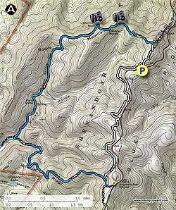
From the Riprap parking area walk the 50 yards along the blue blazed trail to the intersection of the white blazed Appalachian Trail. Turn right uphill on the white blazed trail for 0.4 miles to the intersection of the Riprap Trail.

Turn left on the blue blazed Riprap Trail as it descends through a hollow on the ridge before climbing and arriving at the first vista point in 0.7 miles. In another 0.3 miles reach the second vista and Chimney Rock. From Chimney Rock the trail will begin to descend into Cold Springs Hollow. In 1.7 miles from Chimney Rock the spring fed stream that has come in on the left of Riprap Trail will pass through a small gorge and over a 20ft waterfall.

After passing the waterfall follow the blue blazed Riprap Trail for another 0.3 miles to a large swimming hole. Just past the swimming hole the trail will cross the stream, and pass a trail marker and an overgrown trail that leads to an old Riprap Shelter on the right. Continue straight on the blue blazed Riprap Trail next to the stream for another 0.7 miles to the intersection of the Wildcat Ridge Trail.

Turn left on the blue blazed Wildcat Ridge Trail and shortly cross the stream again before the trail starts heading uphill through a small gorge. In 0.6 miles the Wildcat Ridge Trail will make several switchbacks and become much steeper, as it follows the Wildcat Ridge for another 2.0 miles to the four way intersection with the white blazed Appalachian Trail.

Turn left on the while blazed Appalachian Trail for the remaining 2.8 miles back to the Riprap parking area.

Explore 56 trails near Crimora, VA

Know Before You Go

  • Offers scenic views from Chimney Rock and Rocks Mountain.
  • Features a spring-fed stream with a 20ft waterfall and a 50ft wide swimming hole.
  • Includes a moderately challenging loop with varied terrain and stream crossings.
Interactive topographic map for Riprap Hollow Hike located in Crimora, VA. Click the "View Map" button to load GPS coordinates and trail markers.
Get directions
Distance
9.2 mi
Difficulty
Hard
Type
Loop
Est. Time
4.6 hrs
Elev. Gain
2,207'
Rating
4.1
Added
March 18, 2025
Updated
April 05, 2025

Weather Forecast

Loading...
Total Change
1,363'
Ascent
2,207'
Descent
2,207'
Loading...

Download the GPX Data for Offline Use

Supporters get exclusive access to download trail routes to the MyHikes app for offline use. Stay prepared on your adventure, even without an internet connection! Become a Supporter today to unlock this feature and hike with confidence.

Download Riprap Hollow Hike GPX Data to the MyHikes Mobile App

Features

Vista / Lookout Point
Dogs
Waterfalls
Camping
Water Source
Appalachian Trail logo Appalachian Trail hike

Points of interest

  1. Parking

    38.177108, -78.765093
  2. Main Trailhead

    38.177667, -78.765171

Safety information

For your own safety: plan ahead, let someone know where you'll be, and hike at your own risk.

Hazards

Snakes (Rattlesnakes, Copperheads, others)
Poison Ivy or Poison Oak

Markers

Blaze Color

Blue

Availability

All seasons

Surface type

Dirt

Trip Reports (Reviews)

Rated 4.07 out of 5 based on 83 ratings.

Ready to help fellow hikers? Add a trip report to share your experience and provide valuable insights for other hikers!

By: mark
9.2 miles / 14.8 km
March 05, 2017
First, Thank You Hiking Upward! You have a fantastic and much appreciated site. Review: You know how you can go to a restaurant and everyone shares the sampler appetizer? After tasting it, you kind of wish you just ordered this for yourself rather than ordering an entree? That is this trail. It doesn't have the best stream and swimming hole, but it is really nice. It has nice vistas, but there are better. It has a nice hike through mountain laurel, it has pine forest with dirt trail, nice bottom hardwoods with a rocky trail, and so on. Each time I can think of better, but none that gives me a nice taste of everything like this trail. Depending on how you like samplers, this trail could be rated anything from a 2-5. I gave it a 4 because it is a great hike that I'll definitely come back to, but I still have my favorite entrees elsewhere. I hiked this clockwise (opposite of description) having seen a number of reviews suggesting this and I believe they are right. Just feels like I've earned the vistas if they are near the end and I think it makes the climb a little easier. Other than that, trail was in great shape with only a few rough spots or fallen trees. Impressive fire damage near Chimney Rock. Next, having hiked lots of trails in this guide that are rated a 3 or 4 for difficulty, I think a 4 is probably overstating it here. It is a little longer, but I've hiked 3's that I thought had more strenuous sections.
Legacy Review
By: Don Mac
9.2 miles / 14.8 km
February 07, 2017
Did this hike on Tuesday Feb 7. Views were spectacular. We started from the Rip Rap trail off the AT. Trail was in great shape although we came upon numerous trees down but were able to navigate over them. The stream crossing in several places was a challenge...not wanting to get real wet this time of year we had to carefully choose our steps on slick rocks. The toughest part of this loop came on the return up Rip Rap trail to the Wildcat Ridge trail to the AT. The elevation gain was tough and the trail quite rocky. Overall it was a good hike and took us 5 1/2 hours which included a lunch break.
Legacy Review
By: Stu S
9.2 miles / 14.8 km
December 10, 2016
Did this one on a very cold (mid 20's) but sunny Saturday. Did not see a single other person all day. We parked at the Wildcat lot and hiked in the opposite direction of the write up. There was a stream crossing at the bottom of the Wildcat Ridge trail that required us to get wet. I actually fell in while my buddy crossed it barefoot. It was surprising and sad to find a few huge old eastern hemlocks in the hollow. Just like at Ramsey's Draft they were all dead from woolly adelgid. The views from higher up were fantastic, I suspect this one is best in the winter with no leaves on the trees. Will definitely do this one again in summer to get in the swimming hole.
Legacy Review
No community routes found. To add your own hike as a Community Route for this Trail guide, leave a Trip Report with an attached GPX file.

Popular categories

Scenic mountain view representing vista trails
Vista trails
Scenic gorge of cascades representing waterfall trails
Waterfall hikes
Rugged mountain terrain representing summit trails
Summit trails
Scenic mountain view representing dog-friendly trails
Dog-friendly
Scenic campsite with a view representing camping trails
Camping trails
Appalachian Trail logo representing A.T. hikes
A.T. hikes

You May Also Like

25 Best Day Hikes in North Carolina - Discover the top 25 best day hikes in North Carolina, from breathtaking waterfalls to mountain peaks. Explore hidden gems, scenic views, and trails suitable for all skill levels, perfect for your next outdoor adventure.
Explore

25 Best Day Hikes in North Carolina

Discover the top 25 best day hikes in North Carolina, from breathtaking waterfalls to mountain peaks. Explore hidden gems, scenic views, and trails suitable for all skill levels, perfect for your next outdoor adventure.

Read
🍪 We use cookies to learn about site usage and to serve map tiles. You may block cookies manually in the browser. By continuing you agree. Learn more