The Rim Trail at Robert H. Treman State Park in Ithaca, New York is a difficult 2.5-mile one-way trail that features two waterfall lookout points, including a vista point high above the 115-foot Lucifer Falls which cascades into the Enfield Gorge below.
Trail Description
Mileage listed below is based on the GPS track provided, unless otherwise stated from the trailhead -- meaning the eastern trailhead.
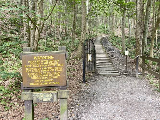
This trail was hiked during COVID-19 along the one-way route heading east to west. The recording begins at the main parking lot and follows signs for the "Rim Trail". If there are no signs, hikers can cross the main bridge south of the parking lot to then hike in along the road adjacent to rental cabins. Just after the rental cabins, hikers will cross a metal gate and just before Cabin #9 is the trailhead for the Rim Trail.
The hike follows several steep staircases but there are about three main climbs throughout the whole Rim Trail. For physically-fit individuals, this trail may be more moderate than difficult, but for the average hiker, these staircases are not easy.
Lower Falls Vista
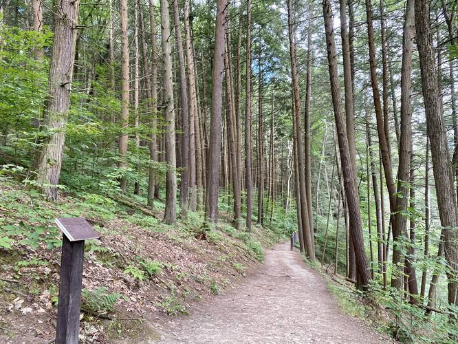
The first climb leads to a beautiful vista above Lower Falls around mile 0.4 (in the track provided) or 0.15-miles from the trailhead. From here, the trail does not have much noteworthy sights other than a beautiful tall Hemlock forest. The trail will undulate a bit before the last two climbs.
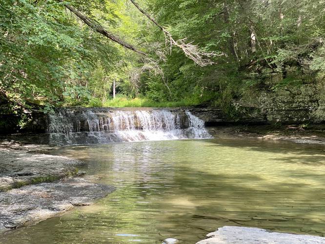
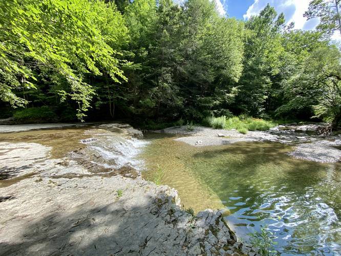
After the Lower Falls vista, the trail will reach a beautiful Hemlock grove around mile 0.55. After the Hemlock grove, the trail does not have much for hikers to see except for one seasonal waterfall along the trail, but it was not flowing at this time and hence I did not take a picture. Around mile 1.7 and mile 1.85 hikers will reach two unnamed smaller waterfalls within Enfield Creek that are not more than 5-feet tall. There will be several small offshoot trails that lead out to Enfield Creek and these waterfalls.
Bridge Crossing and Stairs to Lucifer Falls
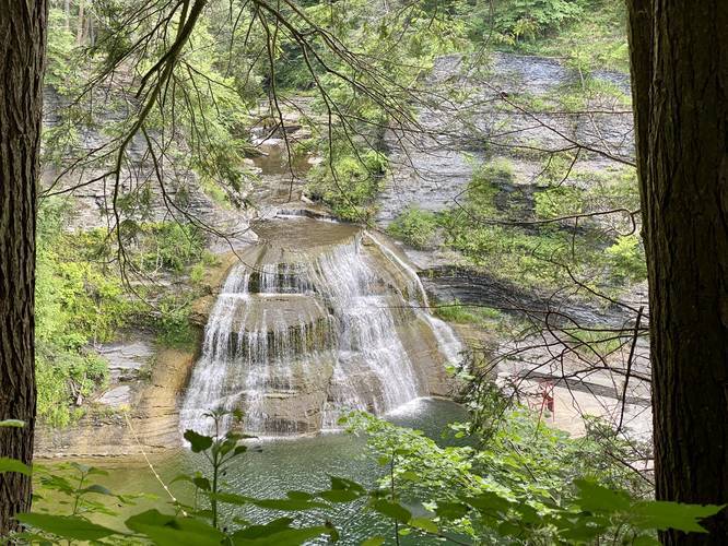
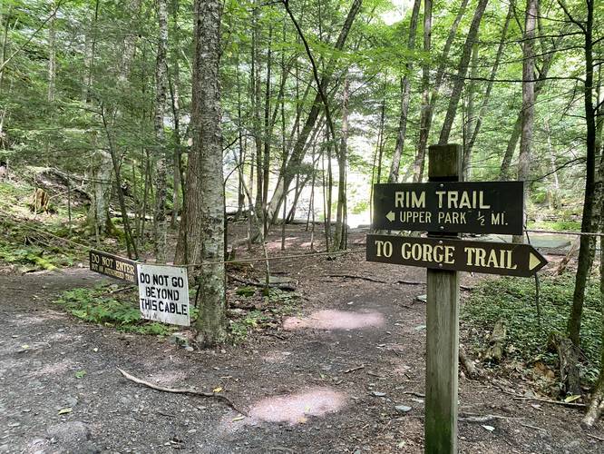
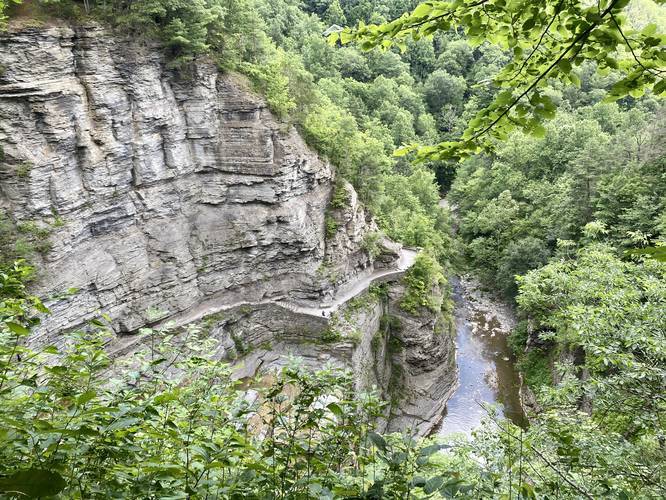
Around mile 1.9, hikers will reach a point in the trail where Lucifer Falls cascades down into the creek straight ahead; however, there are signs labeled "Danger, stay out" with a fork in the trail -- here, hikers can choose to skip hiking uphill to the Lucifer Falls vista and they can hike across the bridge, over Enfield Creek, to the Gorge Trail. Otherwise, the left-hand turn leads up a seemingly-endless series of hand-made stone stairs that climbs for about 140-feet. This climb is not easy at all, but it includes one beautiful vista point along the way up. Just after this climb is the vista for Lucifer Falls.
Lucifer Falls Vista
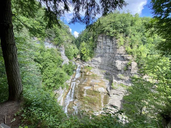
Within the last climb on the trail, hikers will reach the main attraction on this trail -- the Lucifer Falls vista which is about 2.1 miles from the start of this hike or 1.7 miles from the eastern trailhead. Lucifer Falls is a 115-foot waterfall that cascades down Enfield Creek into the gorge below. This vista is unique in that the Gorge Trail, that follows Enfield Creek, boasts a stunning hand-made stone trail consisting of bridges that looks like something out of Lord of the Rings.
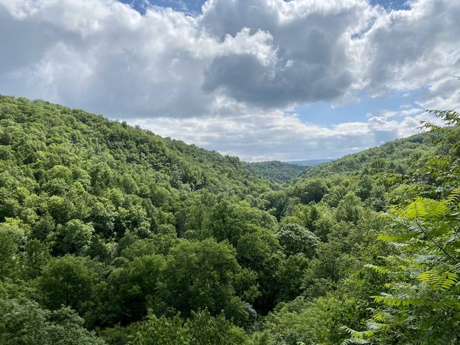
After visiting Lucifer Falls, the trail will meander its way out of the woods with a short 0.3-mile hike to the western trailhead; however, there is one last steep climb before the trail ends. There's one last vista that sits above Enfield Gorge that hikers can stop at for one last point of interest along the hike that sits just before the main climb.
From the western trailhead, hikers can take the Gorge Trail back to parking and enjoy the scenic stonework of the Enfield Gorge and Lucifer Falls up-close.
Trail Length
The hike from the eastern parking lot to the western trailhead is 2.5-miles. The Robert H. Treman State Park map shows the trail is 2.09-miles one-way. Hikers should note this extra mileage when planning their loop hike with the Gorge Trail.
Robert H. Treman Loop Hike
To complete this scenic hike as a loop, hikers can take the Gorge Trail back for a total of 5 miles.
Parking
Hikers can find parking at the eastern main parking lot - listed here under Get Directions. Hikers can also park in the western lot.
Hiking During COVID-19
During COVID-19 and in July, 2020 this trail, and the Gorge Trail at the park, are both one-way trafficked trails, which helps reduce exposure to the disease. Please respect the park rules and hike this trail only one-way. One-way traffic along this trail is from east to west.
Pets
Dogs are allowed if leashed and their waste must be carried out by the hiker.
Restrooms
Hikers will find restrooms at both parking lots.
Blaze Color
Despite the state park map's colors, this trail follows blue circles blazes.
Difficulty
This trail is rated as "Hard" because of the steep hill climbs hikers face when hiking this trail in either direction. Some may find the trail to be "Moderate".
Trail Description
Mileage listed below is based on the GPS track provided, unless otherwise stated from the trailhead -- meaning the eastern trailhead.
This trail was hiked during COVID-19 along the one-way route heading east to west. The recording begins at the main parking lot and follows signs for the "Rim Trail". If there are no signs, hikers can cross the main bridge south of the parking lot to then hike in along the road adjacent to rental cabins. Just after the rental cabins, hikers will cross a metal gate and just before Cabin #9 is the trailhead for the Rim Trail.
The hike follows several steep staircases but there are about three main climbs throughout the whole Rim Trail. For physically-fit individuals, this trail may be more moderate than difficult, but for the average hiker, these staircases are not easy.
Lower Falls Vista
The first climb leads to a beautiful vista above Lower Falls around mile 0.4 (in the track provided) or 0.15-miles from the trailhead. From here, the trail does not have much noteworthy sights other than a beautiful tall Hemlock forest. The trail will undulate a bit before the last two climbs.
After the Lower Falls vista, the trail will reach a beautiful Hemlock grove around mile 0.55. After the Hemlock grove, the trail does not have much for hikers to see except for one seasonal waterfall along the trail, but it was not flowing at this time and hence I did not take a picture. Around mile 1.7 and mile 1.85 hikers will reach two unnamed smaller waterfalls within Enfield Creek that are not more than 5-feet tall. There will be several small offshoot trails that lead out to Enfield Creek and these waterfalls.
Bridge Crossing and Stairs to Lucifer Falls
Around mile 1.9, hikers will reach a point in the trail where Lucifer Falls cascades down into the creek straight ahead; however, there are signs labeled "Danger, stay out" with a fork in the trail -- here, hikers can choose to skip hiking uphill to the Lucifer Falls vista and they can hike across the bridge, over Enfield Creek, to the Gorge Trail. Otherwise, the left-hand turn leads up a seemingly-endless series of hand-made stone stairs that climbs for about 140-feet. This climb is not easy at all, but it includes one beautiful vista point along the way up. Just after this climb is the vista for Lucifer Falls.
Lucifer Falls Vista
Within the last climb on the trail, hikers will reach the main attraction on this trail -- the Lucifer Falls vista which is about 2.1 miles from the start of this hike or 1.7 miles from the eastern trailhead. Lucifer Falls is a 115-foot waterfall that cascades down Enfield Creek into the gorge below. This vista is unique in that the Gorge Trail, that follows Enfield Creek, boasts a stunning hand-made stone trail consisting of bridges that looks like something out of Lord of the Rings.
After visiting Lucifer Falls, the trail will meander its way out of the woods with a short 0.3-mile hike to the western trailhead; however, there is one last steep climb before the trail ends. There's one last vista that sits above Enfield Gorge that hikers can stop at for one last point of interest along the hike that sits just before the main climb.
From the western trailhead, hikers can take the Gorge Trail back to parking and enjoy the scenic stonework of the Enfield Gorge and Lucifer Falls up-close.
Trail Length
The hike from the eastern parking lot to the western trailhead is 2.5-miles. The Robert H. Treman State Park map shows the trail is 2.09-miles one-way. Hikers should note this extra mileage when planning their loop hike with the Gorge Trail.
Robert H. Treman Loop Hike
To complete this scenic hike as a loop, hikers can take the Gorge Trail back for a total of 5 miles.
Parking
Hikers can find parking at the eastern main parking lot - listed here under Get Directions. Hikers can also park in the western lot.
Hiking During COVID-19
During COVID-19 and in July, 2020 this trail, and the Gorge Trail at the park, are both one-way trafficked trails, which helps reduce exposure to the disease. Please respect the park rules and hike this trail only one-way. One-way traffic along this trail is from east to west.
Pets
Dogs are allowed if leashed and their waste must be carried out by the hiker.
Restrooms
Hikers will find restrooms at both parking lots.
Blaze Color
Despite the state park map's colors, this trail follows blue circles blazes.
Difficulty
This trail is rated as "Hard" because of the steep hill climbs hikers face when hiking this trail in either direction. Some may find the trail to be "Moderate".