Loading...

📌 Love our trails? Set MyHikes as your preferred Google source. Add Now ⛰️

Lower Falls Trail

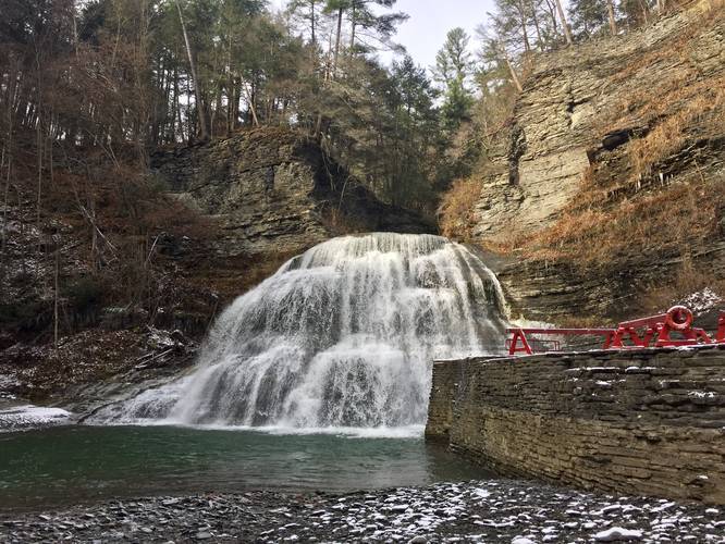
The Lower Falls Trail at Robert H. Treman State Park in Ithaca, New York is an easy 0.3-mile out-and-back trail that leads to a large 40-foot tall waterfall.

This short paved trail is open year-round, giving hikers access to the beautiful Lower Falls cascade. The trail itself is very flat and very short. As it approaches the waterfall and public swimming area, the trail loops (not shown in the GPS data), as it runs both alongside the gorge canyon walls and alongside Enfield Creek.

At the waterfall, take in the views and/or take a swim in Enfield Creek during warmer months.

Parking
Hikers can find parking at the coordinates provided. The parking lot is large enough to fit dozens of cars.

Fee
Between the dates of April 20th to October 20th, the park charges a vehicle entry fee of $8, as of 2019. The fee is collected daily between 8:30AM and 6:00PM.

Pets
Dogs are allowed if leashed and their waste must be carried out by the hiker.
Explore 64 trails near Ithaca, NY

Know Before You Go

  • Lower Falls Trail is an easy, 0.3-mile paved trail in Robert H. Treman State Park, Ithaca, NY, leading to a 40-foot waterfall and swimming area.
  • The trail is open year-round and features a looped section near the waterfall, with parking available at the coordinates provided.
  • A vehicle entry fee of $8 is charged between April 20th and October 20th, and dogs are allowed on leash with waste carried out.
Interactive topographic map for Lower Falls Trail located in Ithaca, NY. Click the "View Map" button to load GPS coordinates and trail markers.
Get directions
Distance
0.3 mi
Difficulty
Easy
Type
Out-and-Back
Est. Time
9 min
Elev. Gain
48'
Rating
5.0
Added
November 11, 2019
Updated
January 26, 2024

Weather Forecast

Juneteenth
High 76°F
Sunny then Chance Showers And Thunderstorms
Tonight
Low 54°F
Chance Showers And Thunderstorms then Partly Cloudy
Saturday
High 74°F
Mostly Sunny
Saturday Night
Low 53°F
Mostly Clear
Sunday
High 77°F
Mostly Sunny
Sunday Night
Low 54°F
Mostly Cloudy then Rain Showers Likely
Monday
High 72°F
Showers And Thunderstorms
Monday Night
Low 55°F
Showers And Thunderstorms
Tuesday
High 75°F
Slight Chance Rain Showers then Mostly Sunny
Tuesday Night
Low 54°F
Partly Cloudy
Wednesday
High 78°F
Mostly Sunny then Slight Chance Showers And Thunderstorms
Wednesday Night
Low 56°F
Chance Showers And Thunderstorms
Thursday
High 79°F
Showers And Thunderstorms Likely
Thursday Night
Low 56°F
Showers And Thunderstorms Likely

Don't let Google decide who you trust.

Loading...
Total Change
48 ft.
15 m
Ascent
48 ft.
15 m
Descent
48 ft.
15 m
Loading...

Download the GPX Data for Offline Use

Supporters get exclusive access to download trail routes to the MyHikes app for offline use. Stay prepared on your adventure, even without an internet connection! Become a Supporter today to unlock this feature and hike with confidence.

Download Lower Falls Trail GPX Data to the MyHikes Mobile App

Features

Dogs
Waterfalls
Water Source

Points of interest

  1. Parking

    42.398063, -76.55688
  2. Main Trailhead

    42.397749, -76.557851
  3. Waterfall

    42.397219, -76.561067
    Waterfall

Safety information

For your own safety: plan ahead, let someone know where you'll be, and hike at your own risk.

Availability

All seasons

Surface type

Universal Access

Trip Reports (Reviews)

Rated 5.0 out of 5 based on 1 rating.

Ready to help fellow hikers? Add a trip report to share your experience!

0.3 miles / 0.5 km
November 09, 2019
Hiking
No community routes found. To add your own hike as a Community Route for this Trail guide, leave a Trip Report with an attached GPX file.

You may also like

Colorado's Million Dollar Highway - Plan a day's drive adventure along the iconic Million Dollar Highway in Colorado. Explore the best short trails, roadside stops, waterfalls, vistas, ghost towns, and hot springs within a ~6 hour road trip.
Explore

Colorado's Million Dollar Highway

Plan a day's drive adventure along the iconic Million Dollar Highway in Colorado. Explore the best short trails, roadside stops, waterfalls, vistas, ghost towns, and hot springs within a ~6 hour road trip.

Read
Glacier's Going-to-the-Sun Road - Discover the breathtaking beauty of Glacier National Park along the iconic Going-to-the-Sun Road. From stunning roadside stops to picturesque waterfalls and vistas, this engineering marvel offers endless opportunities for exploration.
Explore

Glacier's Going-to-the-Sun Road

Discover the breathtaking beauty of Glacier National Park along the iconic Going-to-the-Sun Road. From stunning roadside stops to picturesque waterfalls and vistas, this engineering marvel offers endless opportunities for exploration.

Read
🍪 We use cookies to learn about site usage and to serve map tiles. You may block cookies manually in the browser. By continuing you agree. Learn more