The Gorge Trail at Robert H. Treman State Park in Ithaca, New York is a difficult 2.5-mile one-way trail that features a scenic stonework trail that runs through Enfield Gorge and boasts multiple waterfalls, including the 115-foot tall Lucifer Falls. This trail, like the Watkins Glen Gorge Trail, feels like something out of Lord of the Rings while hiking through.
Trail Description
This trail was recorded during COVID-19 and was a one-way only trail starting from the western trailhead and ending at the eastern trailhead. The hike begins at the trail junction with the Rim Trail, just beyond the restrooms near the western parking lot and follows a flat path for approximately 0.1-miles before reaching the beginning to Enfield Gorge.
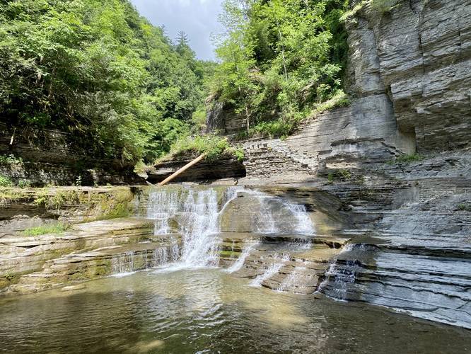
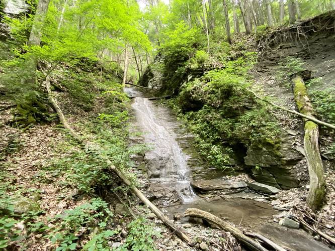
Right where the trail meets Enfield Gorge is where the beautiful trail stonework begins. Hikers will meander their way along the gorge and above Enfield Creek before crossing a stone bridge -- here, hikers will find scenic views of the creek and small waterfalls along the stone handmade trail. Just beyond the first stone bridge, around mile 0.4, is a waterfall that cascades approximately 12-feet down Enfield Creek.
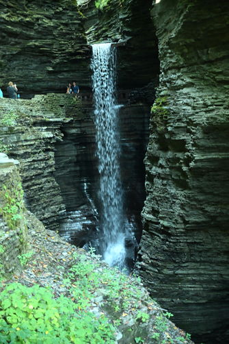
Reaching Lucifer Falls
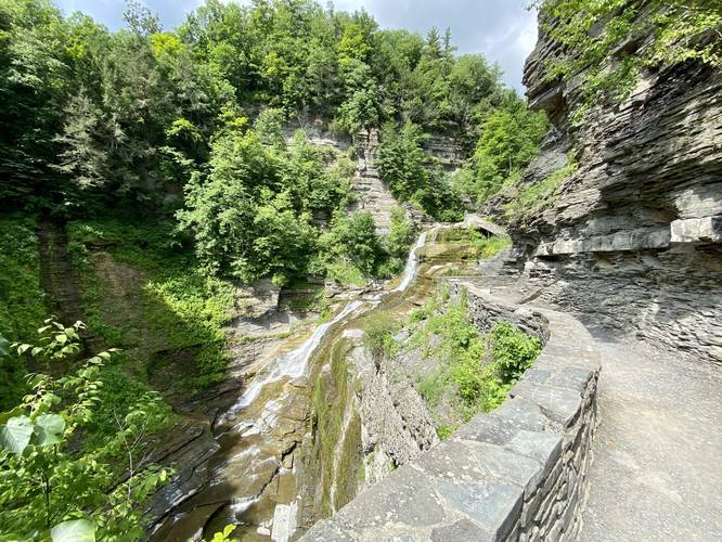
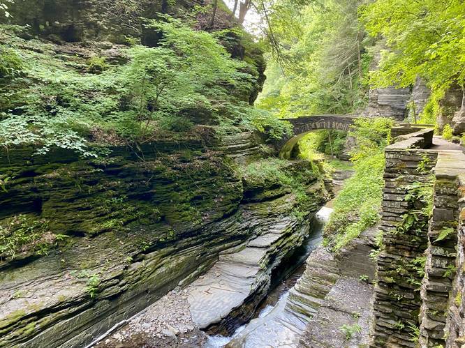
After hiking about 0.55-miles from the western trailhead, hikers will reach the main attraction on this hike -- Lucifer Falls. Lucifer Falls is 115-feet tall and runs strong even during mid Summer. This waterfall is quite the sight to see as the stone staircase wind its way down the side of the waterfall giving hikers different views from the side on their way down.
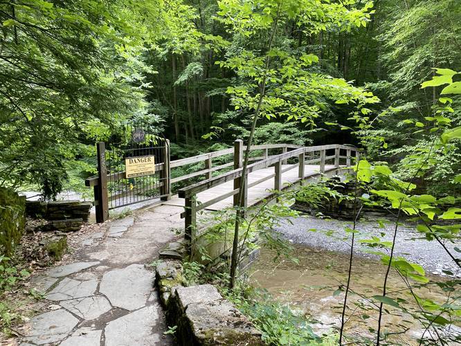
After visiting Lucifer Falls, the trail will turn from beautiful stonework to more of a regular dirt trail. There will be a large staircase that leads downhill toward the Rim Trail connector bridge around mile 0.66 -- here, hikers can choose to hike back along the Rim Trail if they wish.
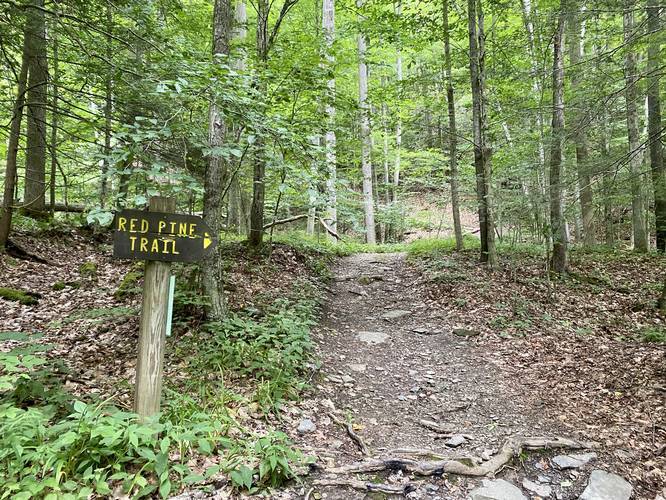
The hike out from the Rim Trail bridge crossing has several sights along the way. There are several smaller waterfalls within Enfield Creek as well, but not all of them are visible during the Summer due to the foliage. At mile 0.85 hikers will reach a junction with the Red Pine Trail.
Hikers can note an additional (unofficial) trail that leads to a little-known waterfall just off of the trail around mile 0.97. This short spur trail looks like a deer trail, but there's a 20-foot waterfall cascading down the hillside at the end. This short spur trail adds 0.1-miles to the hike.
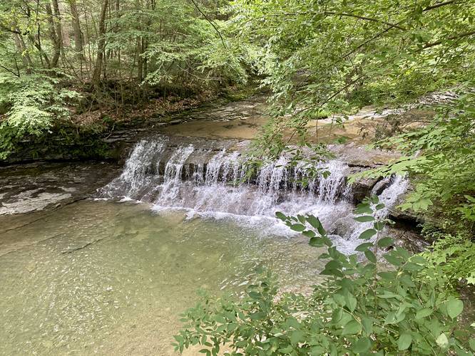
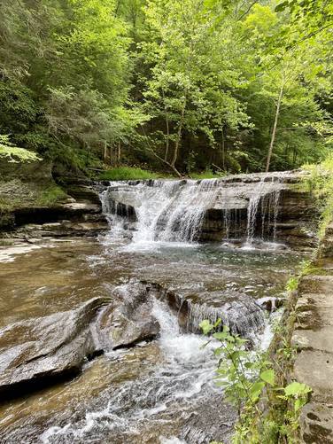
Finally, the last waterfall that hikers get to see with a decent view is around mile 1.25. This waterfall is no more than 5-feet tall, but the stone staircase adjacent to the falls makes for a scenic waterfall view. After this waterfall, there's really not much to see along the trail. The hike from here on out will become more difficult as the trail will have two ascents and two steeper descents. During July 2020, this trail was under construction with brand new stairs being built to alleviate some of the steep hill ascents and descents.
Hikers will reach the parking lot after approximately 2.5-miles of hiking.
Robert H. Treman Loop Hike
To complete this scenic hike as a loop, hikers can take the Rim Trail back for a total of 5 miles.
Parking
Hikers can find parking at the eastern main parking lot - listed here under Get Directions. Hikers can also park in the western lot.
Hiking During COVID-19
During COVID-19 and in July, 2020 this trail, and the Rim Trail at the park, are both one-way trafficked trails, which helps reduce exposure to the disease. Please respect the park rules and hike this trail only one-way. One-way traffic along this trail is from west to east.
Pets
Dogs are allowed if leashed and their waste must be carried out by the hiker.
Restrooms
Hikers will find restrooms at both parking lots.
Blaze Color
Despite the state park map's colors, this trail follows purple circles blazes.
Difficulty
This trail is rated as "Hard" because of the steep hill climbs hikers face when hiking this trail in either direction. Some may find the trail to be "Moderate".
Trail Description
This trail was recorded during COVID-19 and was a one-way only trail starting from the western trailhead and ending at the eastern trailhead. The hike begins at the trail junction with the Rim Trail, just beyond the restrooms near the western parking lot and follows a flat path for approximately 0.1-miles before reaching the beginning to Enfield Gorge.
Right where the trail meets Enfield Gorge is where the beautiful trail stonework begins. Hikers will meander their way along the gorge and above Enfield Creek before crossing a stone bridge -- here, hikers will find scenic views of the creek and small waterfalls along the stone handmade trail. Just beyond the first stone bridge, around mile 0.4, is a waterfall that cascades approximately 12-feet down Enfield Creek.
Reaching Lucifer Falls
After hiking about 0.55-miles from the western trailhead, hikers will reach the main attraction on this hike -- Lucifer Falls. Lucifer Falls is 115-feet tall and runs strong even during mid Summer. This waterfall is quite the sight to see as the stone staircase wind its way down the side of the waterfall giving hikers different views from the side on their way down.
After visiting Lucifer Falls, the trail will turn from beautiful stonework to more of a regular dirt trail. There will be a large staircase that leads downhill toward the Rim Trail connector bridge around mile 0.66 -- here, hikers can choose to hike back along the Rim Trail if they wish.
The hike out from the Rim Trail bridge crossing has several sights along the way. There are several smaller waterfalls within Enfield Creek as well, but not all of them are visible during the Summer due to the foliage. At mile 0.85 hikers will reach a junction with the Red Pine Trail.
Hikers can note an additional (unofficial) trail that leads to a little-known waterfall just off of the trail around mile 0.97. This short spur trail looks like a deer trail, but there's a 20-foot waterfall cascading down the hillside at the end. This short spur trail adds 0.1-miles to the hike.
Finally, the last waterfall that hikers get to see with a decent view is around mile 1.25. This waterfall is no more than 5-feet tall, but the stone staircase adjacent to the falls makes for a scenic waterfall view. After this waterfall, there's really not much to see along the trail. The hike from here on out will become more difficult as the trail will have two ascents and two steeper descents. During July 2020, this trail was under construction with brand new stairs being built to alleviate some of the steep hill ascents and descents.
Hikers will reach the parking lot after approximately 2.5-miles of hiking.
Robert H. Treman Loop Hike
To complete this scenic hike as a loop, hikers can take the Rim Trail back for a total of 5 miles.
Parking
Hikers can find parking at the eastern main parking lot - listed here under Get Directions. Hikers can also park in the western lot.
Hiking During COVID-19
During COVID-19 and in July, 2020 this trail, and the Rim Trail at the park, are both one-way trafficked trails, which helps reduce exposure to the disease. Please respect the park rules and hike this trail only one-way. One-way traffic along this trail is from west to east.
Pets
Dogs are allowed if leashed and their waste must be carried out by the hiker.
Restrooms
Hikers will find restrooms at both parking lots.
Blaze Color
Despite the state park map's colors, this trail follows purple circles blazes.
Difficulty
This trail is rated as "Hard" because of the steep hill climbs hikers face when hiking this trail in either direction. Some may find the trail to be "Moderate".