-
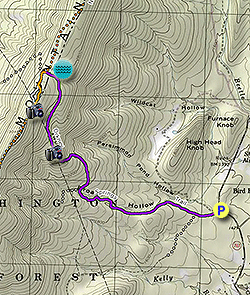
Mile 0.0 - From the parking area DO NOT take the forestry road at the closed gate. Instead, follow the purple blazed Orkney Springs Trail in the opposite direction. The trail is wider here and will shortly pass through a stand of small pine.
-
Mile 0.25 - Turn right at the first intersection continuing to follow the purple blazes. The trail will become more steep, and the creek in Broad Hollow becomes apparent on the right. Cross the creek three times within 0.3 miles.
-
Mile 1.25 - Shortly after crossing the creek for the third and final time, arrive at the next intersection. Stay right and the trail will become steeper. Where the trail makes a turn back to the left it passes through a seam of iron ore that supplied the furnaces during the 1800's. Many of the rocks along the trail are heavily oxidized, and you can find them where the iron ore seam is easily visible.
-
Mile 1.8 - Arrive at Riddle's Cut which is visible extending for miles into the Shenandoah Valley. The Orkney Springs Trail will now follow the cut uphill. In 50 yards there is a rock outcrop on the right. If you climb to the top of the outcrop catch a nice view of the valley and small man made lake. Continue for another 50 yards uphill, at which point the purple blazed Orkney Springs Trail re-enters the forest. Just before arriving at the ridge look for a side trail on the right. This leads to a spring fed pond. Continue the short distance to the ridge.
-
Mile 2.5 - At the ridge follow the orange blazed North Mountain Trail to the left and south. In 100 yards stay left again uphill where the Long Mountain Trail now follows a wider service road. Continue up the trail for 0.17 miles at which point the North Mountain Trail turns left off the service road. Stay straight on the service road, and follow it for another 0.1 miles to the western side of Riddle's Cut.
-
Mile 2.75 - From the cut look west into the Lost River Valley in West Virginia. Turn left uphill and crest the mountain where the orange blazed North Mountain Trail crosses. Just beyond the crest is a beautiful spot in the cut looking east into the Shenandoah Valley and hike turn around point. Retrace your route to return.
- Mile 5.6 - Arrive back a the parking area off VA 717.
Riddle's Cut Hike
Know Before You Go
- Distance
- 5.6 mi
- Difficulty
- Hard
- Type
- Out-and-Back
- Est. Time
- 2.8 hrs
- Elev. Gain
- 1,483'
- Rating
- 0.0
- Added
- February 17, 2025
- Updated
- April 05, 2025
Weather Forecast
Don't let Google decide who you trust.


<strong>Trail map and elevation chart not rendering in print mode?</strong> Simply scroll to the trail map section, then try printing again!
449 m
452 m
451 m
Features
Points of interest
-
Parking
38.818095, -78.797686 -
Main Trailhead
38.818095, -78.797686
Safety information
For your own safety: plan ahead, let someone know where you'll be, and hike at your own risk.
Hazards
Markers
Blaze Color
PurpleAvailability
Surface type
Trip Reports (Reviews)
Ready to help fellow hikers? Add a trip report to share your experience!


You may also like

25 Best Day Hikes in Virginia
Explore the top hikes in Virginia, from iconic trails in Shenandoah National Park to hidden gems in the Blue Ridge Mountains. Find your next unforgettable outdoor adventure.

25 Best Day Hikes in West Virginia
Discover 25 of the best day hikes in West Virginia, from scenic overlooks to wilderness trails—perfect for every level of hiker.

25 Best Day Hikes in North Carolina
Discover the top 25 best day hikes in North Carolina, from breathtaking waterfalls to mountain peaks. Explore hidden gems, scenic views, and trails suitable for all skill levels, perfect for your next outdoor adventure.

Best of the Alps: Hiking, Adventure & Scenery
Plan your ultimate European Alps adventure! Discover the best hiking trails, epic scenery, and villages in the Swiss Alps, Dolomites, Chamonix, and Lake Como.

