Loading...

❄️ WINTER SALE! 50% OFF on Supporter Accounts — now through January 31st. Unlock a full year of exclusive website & app perks. Learn More.

Rich Hole Hike

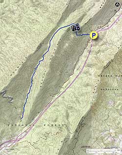
The Rich Hole Wilderness is perhaps Virginia’s most accessible federally designated wilderness, located just off of Interstate 64 west of Lexington. One trail cuts through this wilderness, and it must be hiked as either an out-and-back or with a car shuttle. Although you can start at either end, the stiffer climb is on the northern end of the wilderness. Because the northern end is the more interesting part of this hike, we recommend you start and end here, which gives you more flexibility on the hike’s length. There are no established campsites along this route, though camping possibilities exist.

This area was designated federal wilderness in 1988 and comprises 6,532 acres, making it the seventh largest National Forest Wilderness in Virginia. A bill is in Congress to expand this wilderness to over 11,000 acres, which would make it the second largest contiguous wilderness in the commonwealth. Despite its proximity to the interstate, it is seldom visited outside of hunting season.

  • Mile 0.0 – Park on the side of County Road 850, just west of the Rockbridge County/Highland County line. There is a wilderness sign here and a kiosk visible from the road, but the parking comes up fast, so watch for the Highland County sign when driving to the trailhead.

  • Mile 0.1 – Pass a small creek just after a trail kiosk.

  • Mile 0.6 – A large boulder on the left side of the trail provides a wonderful view of North Mountain and the Simpson Creek valley through which Interstate 64 traverses. To the right on North Mountain is a set of radio antennae, located near the start of the Pete’s Cave hike. This is the best vista on this hike.

  • Mile 1.0 – After the vista, you will climb along the edge of the Simpson Creek headwaters. Along the way, look for evidence of the April 2012 fire that devastated much of this wilderness and continues to affect trail conditions today. Fortunately for us hikers, this trail has a very dedicated trail maintainer. Of the three times Hiking Upward traversed this trail in preparation for this write up, we encountered the trail maintainer twice and helped him with trail work once. Trail workers were the only other people we ever encountered on this trail! At this one mile mark, the trail reaches a ridge and takes a left turn before an exceptionally steep climb on the ridge. Halfway up this climb, a break in the trees allows for a view to the north towards Goshen Pass and Great North Mountain. There are no blazes on this trail, as it is nearly entirely within federally designated wilderness. Should you have any trouble following the trail during this climb, remember keep to the right side of the ridge as you climb and look for a depressed line of ground, which is the trail.

  • Mile 1.2 – The trail reaches its highest point as it curves to the left onto the north slope of Brushy Mountain. Because the trail now follows the north slope, it can become very icy during the colder months, even if it has been dry and clear until now. From here, the trail slowly descends in a valley over the next five miles.

  • Mile 1.9 – Cross North Branch Simpson Creek. There will be 15 additional crossings over the next 4+ miles, and the same number of crossings on the way back. You may think that the stream is the trail at times! Anticipate wet feet, and do not consider this hike when water levels are high. Or, if this hike is out-and-back, turn around whenever it suits you. There are no more views along this hike, just a peaceful trek through a wilderness valley.

  • Mile 5.6 – Reach the shuttle parking lot. Turn around here to return to your car if you did not drop a shuttle car here.
  • Mile 11.3 – Reach the parking lot after hiking in full out-and-back
By HikingUpward Contributor: Jeff Monroe
Explore 37 trails near Goshen, VA

Know Before You Go

  • The Rich Hole Hike is an 11.3-mile out-and-back trail located in the Rich Hole Wilderness near Goshen, VA, offering a relatively accessible wilderness experience.
  • The trail features a challenging climb on the northern end with the best vista at mile 0.6 and numerous creek crossings after mile 1.9, requiring hikers to anticipate wet feet and avoid during high water levels.
  • The Rich Hole Wilderness is seldom visited outside of hunting season, lacks blazes, and is maintained by dedicated trail workers, with potential camping opportunities, but no established campsites along the route.
Interactive topographic map for Rich Hole Hike located in Goshen, VA. Click the "View Map" button to load GPS coordinates and trail markers.
Get directions
Distance
11.3 mi
Difficulty
Hard
Type
Out-and-Back
Est. Time
5.7 hrs
Elev. Gain
2,895'
Rating
3.0
Added
February 17, 2025
Updated
April 05, 2025

Weather Forecast

Loading...
Total Change
1,919'
Ascent
2,895'
Descent
2,895'
Loading...

Download the GPX Data for Offline Use

Supporters get exclusive access to download trail routes to the MyHikes app for offline use. Stay prepared on your adventure, even without an internet connection! Become a Supporter today to unlock this feature and hike with confidence.

Download Rich Hole Hike GPX Data to the MyHikes Mobile App

Features

Vista / Lookout Point
Dogs
Camping
Water Source

Points of interest

  1. Parking

    37.86978, -79.625004
  2. Main Trailhead

    37.86978, -79.625004

Safety information

For your own safety: plan ahead, let someone know where you'll be, and hike at your own risk.

Hazards

Snakes (Rattlesnakes, Copperheads, others)
Poison Ivy or Poison Oak

Markers

Blaze Color

Blue

Availability

All seasons

Surface type

Dirt

Trip Reports (Reviews)

Rated 3.0 out of 5 based on 1 rating.

Ready to help fellow hikers? Add a trip report to share your experience and provide valuable insights for other hikers!

By: JLP
11.3 miles / 18.2 km
September 27, 2019
So, I'm possibly being a little unfair to this hike by giving it three stars instead of four, because it's not the hike's fault I couldn't set up a shuttle. I intended to do this as an out-and-back from the north end, heading down to almost the southern terminus and then retracing my steps (I don't really enjoy backtracking, especially uphill, though.) Once I got going, I just decided to do the whole thing and walk the road back. Possibly not a great decision because there's not a lot of shoulder there, but there also wasn't much traffic for midday Friday five cars passed me the whole time. It definitely saved me some elevation gain while the road had some subtle elevation gain itself, it wasn't nearly as bad as the trail. Anyway, things I would have liked to have known/confirmed ahead of time: a) I would have felt comfortable driving my non-high clearance car on FDR 108 to the southern parking - I've definitely driven it on worse. b) The viewpoint is exactly as advertised - lovely, if only you didn't have 64 right there. c) the climb after the viewpoint is STEEP. STEEP STEEP. Take the time to grab glimpses through the trees as you catch your breath, because it is a nice view. d) the trail down from there is lovely and not too steep - no more overlooks, but nice woods views. It's a bit rocky in places, and not always well-defined, but not that faint, either. I was surprised to see some old trail blazes when I was well into the hike, but don't count on them it is a wilderness area, after all. e) yes, there are lots of stream crossings, but don't break out your watershoes, especially if it's late summer/fall. Maybe the crossings are interesting in the spring, but the stream is a tiny little thing that you could practically jump in spots, regardless of depth, and in the fall it's not much more than an inch in most places. I did spot a few pools that you could actually wade in (as in, water above your ankles but probably below your knees), but those were few and towards the lower end of the trail. f) I'm betting this is a definite 5 for solitude. If it were closer to where I lived, such that I could set up that shuttle hike with friends, I would definitely do it again. As it is, I probably won't. Side note: the trail registers on both ends could stand to be replaced.
Legacy Review
No community routes found. To add your own hike as a Community Route for this Trail guide, leave a Trip Report with an attached GPX file.

Popular categories

Scenic mountain view representing vista trails
Vista trails
Scenic gorge of cascades representing waterfall trails
Waterfall hikes
Rugged mountain terrain representing summit trails
Summit trails
Scenic mountain view representing dog-friendly trails
Dog-friendly
Scenic campsite with a view representing camping trails
Camping trails
Appalachian Trail logo representing A.T. hikes
A.T. hikes

You May Also Like

25 Best Day Hikes in North Carolina - Discover the top 25 best day hikes in North Carolina, from breathtaking waterfalls to mountain peaks. Explore hidden gems, scenic views, and trails suitable for all skill levels, perfect for your next outdoor adventure.
Explore

25 Best Day Hikes in North Carolina

Discover the top 25 best day hikes in North Carolina, from breathtaking waterfalls to mountain peaks. Explore hidden gems, scenic views, and trails suitable for all skill levels, perfect for your next outdoor adventure.

Read
🍪 We use cookies to learn about site usage and to serve map tiles. You may block cookies manually in the browser. By continuing you agree. Learn more