The Red Spruce Trail at Sinnemahoning State Park near Austin, Pennsylvania is an easy 2.4-mile out-and-back trail that leads to a wildlife viewing area and passes wetlands through a mixed forest of dense hardwoods, hemlocks, and pines.
Trails
This hike follows the Lowlands Trail and the Red Spruce Trail (yellow blazes). Note that as of March 2022, the park map for the Red Spruce Trail (in relation to 40 Maples Day Use Area) is a bit outdated. Hikers will want to follow the Lowlands Trail - heading east - for a short while before finding the trailhead for the Red Spruce Trail. This GPS data includes that section of the walk. Note that the length of the Red Spruce Trail is closer to 0.9-miles one-way starting at each marked trailhead. This hike includes 0.6-miles out-and-back along the Lowlands Trail to reach the Red Spruce Trail.
Hike Description
Hikers will start at the 40 Maples Day Use Area at the parking coordinates provided before walking west to reach the Lowlands Trail. Here, take a right-hand turn to follow the Lowlands Trail for a short while (less than 0.3-miles). The Lowlands Trail will pass behind the day use area (which include restrooms) and a small section of wetland before reaching the Red Spruce Trail. After the trail passes a bend - and a small section of wetland off-trail - the Lowlands Trail will straighten out before reaching a wooden post (trailhead) for the Red Spruce Trail.
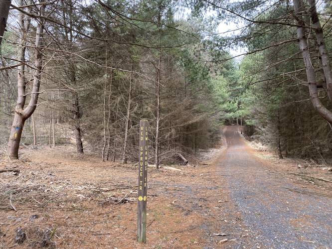
Red Spruce Trail trailhead - Mile 0.3
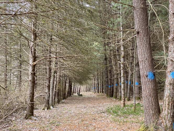
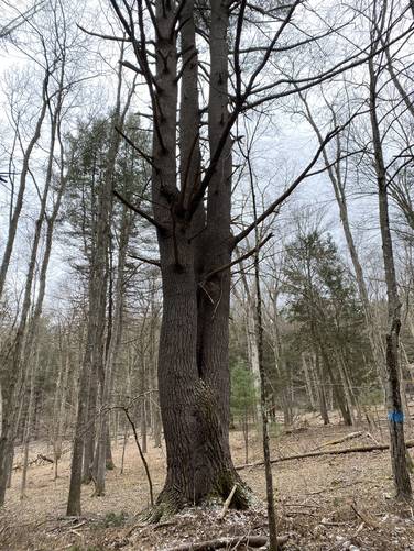
At mile 0.3, take a left-hand turn for the Red Spruce Trail. Immediately after, the trail will head uphill slightly before it passes underneath a beautiful evergreen forest which feels like a "tree tunnel". There's a bench located half-way through this "tree tunnel", which allows hikers to take a break and enjoy their surroundings. As of March 2022, when this trail was tracked, there were extra paint marks on the trees here from loggers which unfortunately took away from the natural beauty. On the northern end of this trail is a single old-growth Hemlock tree located just off-trail.
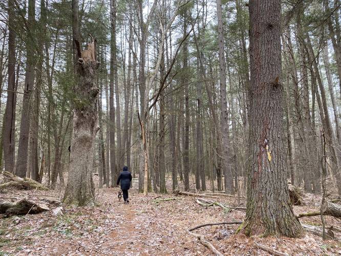
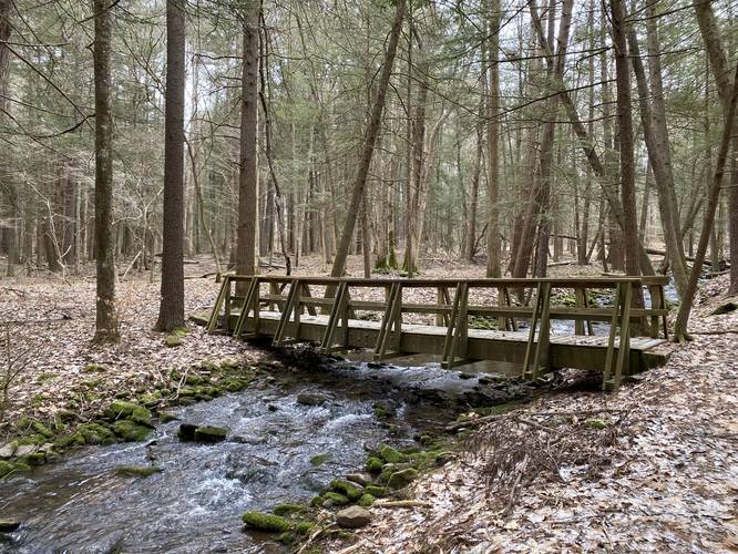
Hemlock Forest - Mile 0.6
After passing the evergreen "tree tunnel" the trail will shortly lead into a more open space with what appear to be some old-growth hemlock trees. The forest here is more open with massive trees that stretch high into the sky. This section of forest is by far the most scenic along the trail. At the opposite end, hikers will find a small footbridge that crosses a creek.
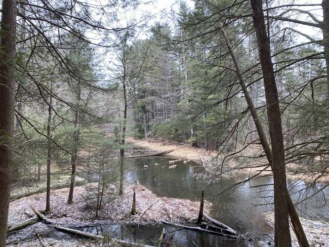
Wildlife Viewing Area - Mile 0.9
At mile 0.9, hikers will reach 2 benches that face First Fork Sinnemahoning Creek which serves as a wildlife viewing area. Here, hikers can take another break before heading onward.
Campground at End of Trail
Finally, hikers will make their way to the end of the trail, which leads to the paid-campsites at Sinnemahoning State Park. This is where the out-and-back hike is halfway complete and where the hiker can make their way back, unless they wish to walk along the road instead.
Parking
Hikers will find parking at the coordinates provided which lead to the 40 Maples Day Use Area at Sinnemahoning State Park.
Pets
Dogs are allowed if leashed and their waste must be carried out by the hiker.
Camping
Camping is not allowed on this trail, unless the camper has a reservation at the pre-paid campsites located at the northern terminus of this trail.
Restrooms
Hikers will find day use area restrooms near the trailhead at the 40 Maples Day Use Area. There are also bathrooms at the Sinnemahoning Wildlife Center located in the middle of the park.
Trails
This hike follows the Lowlands Trail and the Red Spruce Trail (yellow blazes). Note that as of March 2022, the park map for the Red Spruce Trail (in relation to 40 Maples Day Use Area) is a bit outdated. Hikers will want to follow the Lowlands Trail - heading east - for a short while before finding the trailhead for the Red Spruce Trail. This GPS data includes that section of the walk. Note that the length of the Red Spruce Trail is closer to 0.9-miles one-way starting at each marked trailhead. This hike includes 0.6-miles out-and-back along the Lowlands Trail to reach the Red Spruce Trail.
Hike Description
Hikers will start at the 40 Maples Day Use Area at the parking coordinates provided before walking west to reach the Lowlands Trail. Here, take a right-hand turn to follow the Lowlands Trail for a short while (less than 0.3-miles). The Lowlands Trail will pass behind the day use area (which include restrooms) and a small section of wetland before reaching the Red Spruce Trail. After the trail passes a bend - and a small section of wetland off-trail - the Lowlands Trail will straighten out before reaching a wooden post (trailhead) for the Red Spruce Trail.
Red Spruce Trail trailhead - Mile 0.3
At mile 0.3, take a left-hand turn for the Red Spruce Trail. Immediately after, the trail will head uphill slightly before it passes underneath a beautiful evergreen forest which feels like a "tree tunnel". There's a bench located half-way through this "tree tunnel", which allows hikers to take a break and enjoy their surroundings. As of March 2022, when this trail was tracked, there were extra paint marks on the trees here from loggers which unfortunately took away from the natural beauty. On the northern end of this trail is a single old-growth Hemlock tree located just off-trail.
Hemlock Forest - Mile 0.6
After passing the evergreen "tree tunnel" the trail will shortly lead into a more open space with what appear to be some old-growth hemlock trees. The forest here is more open with massive trees that stretch high into the sky. This section of forest is by far the most scenic along the trail. At the opposite end, hikers will find a small footbridge that crosses a creek.
Wildlife Viewing Area - Mile 0.9
At mile 0.9, hikers will reach 2 benches that face First Fork Sinnemahoning Creek which serves as a wildlife viewing area. Here, hikers can take another break before heading onward.
Campground at End of Trail
Finally, hikers will make their way to the end of the trail, which leads to the paid-campsites at Sinnemahoning State Park. This is where the out-and-back hike is halfway complete and where the hiker can make their way back, unless they wish to walk along the road instead.
Parking
Hikers will find parking at the coordinates provided which lead to the 40 Maples Day Use Area at Sinnemahoning State Park.
Pets
Dogs are allowed if leashed and their waste must be carried out by the hiker.
Camping
Camping is not allowed on this trail, unless the camper has a reservation at the pre-paid campsites located at the northern terminus of this trail.
Restrooms
Hikers will find day use area restrooms near the trailhead at the 40 Maples Day Use Area. There are also bathrooms at the Sinnemahoning Wildlife Center located in the middle of the park.