The Lowlands Trail is a 4.8-mile one-way scenic hike that follows the First Fork Sinnemahoning Creek through the upper end of the Sinnemahoning State Park.
Trails
The Lowlands Trail was built on the former Buffalo & Susquehanna railroad bed, that operated in the early 1900's. The railroad was then purchased in 1932 by the Baltimore and Ohio Railroad. This rail-line was closed after being badly damaged in the devastating flood of 1942.
Today, the Lowland Trail is a multi-use trail (hiking, biking, cross-country skiing and snowmobile).
Blazes are Orange Diamonds used as the Snowmobile Trail Markers. There are a number of wooden trail posts and signs, and several Interpretive displays about the wildlife and the local ecosystem can be viewed along the way. The pathways of the Lowlands Trail easy to follow and are either topped with crushed limestone fines on the northern section to the 40 Maples Day Use Area or mowed grass to the south of the 40 Maples Day Use Area.
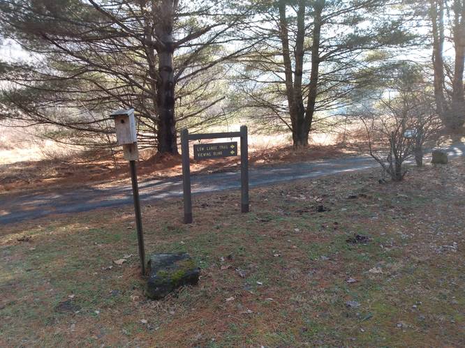
As of February 2023, the trails (Lowlands and Red Spruce) had some work in-progress at the 40 Maples Day Use Area. There has been brush clearing and clean-up work done to open up the area (see pictures) and there is a new Wildlife Viewing Blind added to view the marshland. The Lowlands Trail passes behind the 40 Maples Day Use Area, and it was a little confusing how different trails intersect, and how to stay on the Lowlands Trail when hiking on that trail. The Sinnemahoning State Park Trail map has a enlarged insert that helps to show the trails in the 40 Maples Day use Area.
Hike Description
Hikers can start at the Wildlife Viewing Area at the parking coordinates provided and walk a short distance to the south end of the parking area for about 200 feet to reach the Lowlands Trailhead post.
The Lowlands Trail has innumerable sights for the hiker to take in. Below highlights just a few of the main ones.
North Lowlands Trail Trailhead - Mile 0.0
Hikers will find a large wooden sign pointing the direction to follow which will pass by an information kiosk. It is a good idea to pick-up a trail map to carry along on the hike. There is also a picnic area that has a table and charcoal grill right at the parking lot area. This trailhead area is perfect for families, walkers, and day hikers since this is an easily accessed stopping point.
Wildlife Viewing Area - Mile 0.1
At mile 0.1, hikers will reach a gazebo that faces a meadow toward the First Fork Sinnemahoning Creek which serves as a wildlife viewing area. Here, hikers can take a wildlife viewing break before heading onward. This area is known to have wild elk grazing at times.
Wetlands Viewing Area - Mile 0.3
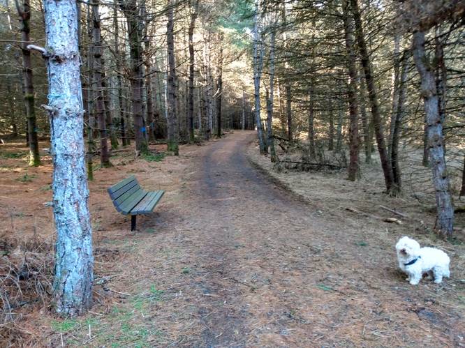
At mile 0.3, on the right-side of the trail lays a marsh populated with cattails. There is a spur trail that goes to the crest of the embankment. A bench and table provide a good spot to watch for a variety of birds, water foul and semiaquatic creatures who call this marsh home such as turtles and frogs, salamanders, and muskrats.
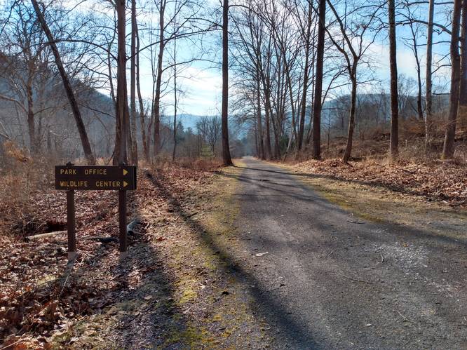
Lowlands Trailhead at Wildlife Center (Park Office) - Mile 1.1
At mile 1.1, hikers will find a marker pointing the way to the Park Office and Wildlife Center. This side trail leads to a bridge that crosses Upper Logue Run and then goes slightly uphill through the woods for about 0.1 miles to the Sinnemahoning Wildlife Center. Although there is a lot to see at the Wildlife Center, hikers may opt to continue on the Lowlands Trail and pass-on-by the Wildlife Center excursion.
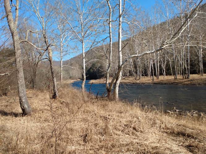
Lowlands River Walk - Miles 1.3 to 2.4
Not far beyond the Wildlife Center, the hiker will find that the Lowlands Trail begins to closely follow the bank of the First Fork Sinnemahoning Creek. This section offers many scenic views of not only the creek and also the hillside across the stream. One of the best views here, is at mile 1.3. The dark blue water of the First Fork Sinnemahoning Creek contrasts against the groves of white Buttonwood Trees (American Sycamores) on the far bank.
Lowlands Pine Forest - Miles 2.4 to 3.3
After leaving creek side, hike travels through a dense pine forest. At mile 2.8, the hiker will find a trail bench for hikers to soak in the woodland surroundings. Not far beyond this point, the hiker will emerge from the forest and enter an open area, where the Lowlands Trail intersects with the Red Spruce Trail at a wooden trail posts to indicate which direction to continue on the Lowlands Trail. The Lowlands Trail will pass behind the 40 Maples Day Use Area (which include restrooms).
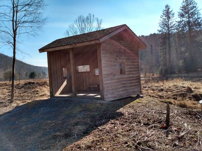
Wildlife Viewing Blind - Mile 3.4
At mile 3.4, on the right-side of the trail lays another marshland area. There is a spur trail that goes to a newly constructed Wildlife Viewing Blind to view the marshland. The three-sided building has a number of open windows in the wall that faces the wetlands and provides a "hot diggity dog" viewing opportunity to watch and enjoy those wetland creatures in their natural environment.
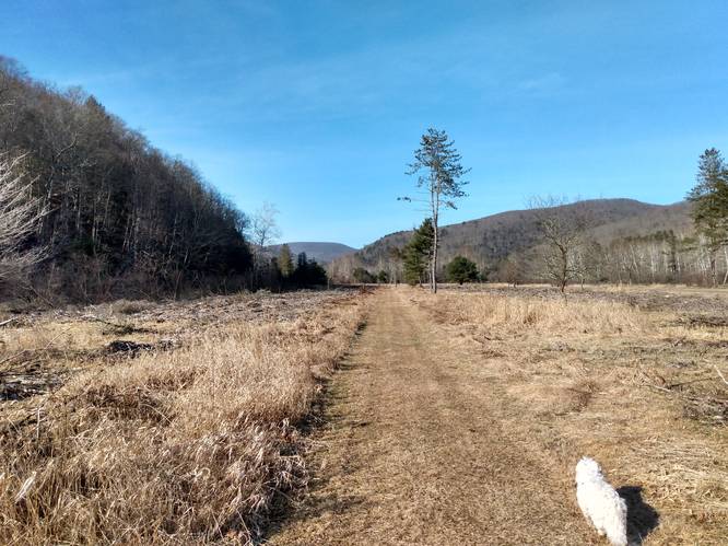
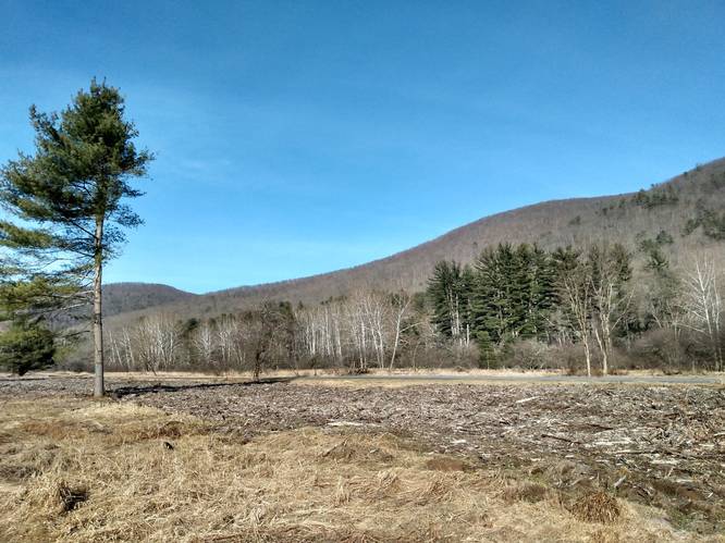
Lowlands Meadow Walk - Miles 3.4 to 4.8
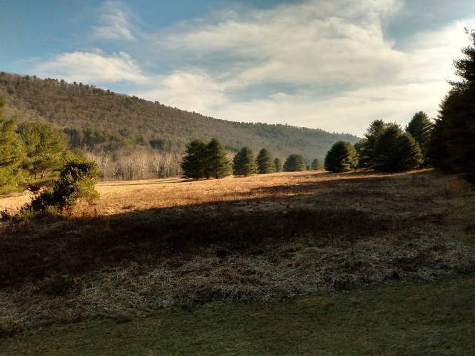
Beyond the 40 Maples Day Use Area, the hiker will find that Lowlands Trail enters meadowlands. This is the most remote section of trail. Although technically not a vista, the views in the open flatland are the most scenic. One of the best views here, is at mile 3.7 looking to the north. The blue sky above the muted (winter-time) distance hills with the wide open valley floor stretching out below gives the hiker the feeling of a vast sparseness. Maybe even to the point that the hiker might for a brief moment imagine, "I must be in heaven".
Ending the Lowlands Trail Hike
At mile 4.6, the Lowlands Trail turns to the west and finishes with a slightly steep climb out of about 80 feet in elevation change in last 800 feet of trail. At the end of the climb, the hiker arrives at the southern most trailhead of the Lowlands Trail. This trailhead is located along the Park Paved Road but has no parking area for parking vehicles. The hiker has a bit of a quandary, and must choice one of three options. The first option is to continue to hike south on the Park Paved Road for one more mile to the Lake Day Use Area. A second option is to hike on the Park Paved Road north for about one mile back to the 40 Maples Day Use Area. Third option is to hike back on the Lowlands Trail heading this time in the northerly direction.
Wildlife Viewing Tips
No elk were observed at the Sinnemahoning State Park on this hike. However, a small herd of elk were seen on private property on the drive along Route 872 about 10 miles north of the Sinnemahoning State Park near the village of Costello. Due to the fact that it would have been dangerous to park along the highway, and in respect to the property owner, no attempt was made to stop, watch or take pictures.
One of these elk was a large bull with impressive antlers, and a notable sighting. The herd was only about 50 feet from the highway.
The Lowlands Trail has several areas having the advantage of wildlife viewing vistas, and here is certainly a splendid wildlife viewing place, especially for the elk. The strategy is to know the best times and where to look and find the elk in their seasonal migrations. In the spring as the weather warms and food becomes more plentiful, elk do move to the meadows to feed on the grasses at the edges of the woods. In the winter, they are more likely to be in the more wooded areas of the forest and down in the sheltered hollows.
To be successful, the best times are early in the morning or at dusk in the evening. Find a comfortable viewing spot and to sit quietly for long intervals of time, to make that elk sighting and this a great place to do just that. Binoculars are recommended. Hiking the Lowlands Trail in its entirety, to cover the distance, leaves very little time for sitting and watching for wildlife, so the likelihood of seeing elk or any other wildlife greatly diminishes on longer hikes where the hiker is continuously moving.
Parking
Hikers can find parking at the coordinates provided at the Wildlife Viewing Area at Sinnemahoning State Park which is near the north trailhead of the Lowlands Trail.
The southern most trailhead of the Lowlands Trail is located along the Park Paved Road (joint use road for both Autos and snowmobiles) but has no parking area for parking vehicles while hiking or cross country skiing or bicycling. For that reason, it is recommended to start hiking at the Wildlife Viewing Area near the north trailhead of the Lowlands Trail. Two additional parking options, are described below to access the Lowlands Trail in between the trail end points.
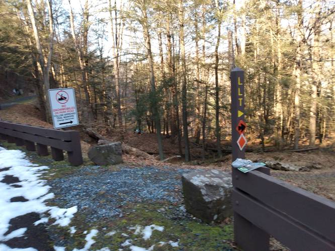
Hikers can find parking at the Park Office and Wildlife Center at Sinnemahoning State Park. Hikers starting at the Wildlife Center can begin by walking a short distance south along the Park Paved Road for about 300 feet to reach the Lowlands Trailhead post. At the "LLT" Post, take a left-hand turn on the Lowlands Trail access path. Continue across the lawn for about 200 feet to the next "LTT" post with orange diamond and turn right. The trail will head downhill slightly through the woods to a bridge that crosses Upper Logue Run and onto the Lowlands Trail immediately beyond the bridge. The Lowlands Trail passes below the Park Office and Wildlife Center in both directions.
Hikers can also start at the parking area at the 40 Maples Day Use Area at Sinnemahoning State and begin by walking west to reach the Lowlands Trail. The Lowlands Trail passes behind the 40 Maples Day Use Area in both directions.
Pets
Dogs are allowed if leashed and their waste must be carried out by the hiker.
Camping
Camping is not allowed on this trail, unless the camper has a reservation at the pre-paid campsites located at the park campground located about 1 mile south of this trail.
Restrooms
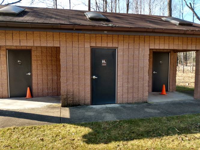
Hikers will find non-flush restrooms near the north trailhead at the Wildlife Viewing Area which are open year-around. There are flush bathrooms available during office hours inside the Sinnemahoning Wildlife Center located in the middle of the park. Hikers will also find non-flush restrooms at the 40 Maples Day Use Area which are open year-around.
Trails
The Lowlands Trail was built on the former Buffalo & Susquehanna railroad bed, that operated in the early 1900's. The railroad was then purchased in 1932 by the Baltimore and Ohio Railroad. This rail-line was closed after being badly damaged in the devastating flood of 1942.
Today, the Lowland Trail is a multi-use trail (hiking, biking, cross-country skiing and snowmobile).
Blazes are Orange Diamonds used as the Snowmobile Trail Markers. There are a number of wooden trail posts and signs, and several Interpretive displays about the wildlife and the local ecosystem can be viewed along the way. The pathways of the Lowlands Trail easy to follow and are either topped with crushed limestone fines on the northern section to the 40 Maples Day Use Area or mowed grass to the south of the 40 Maples Day Use Area.
As of February 2023, the trails (Lowlands and Red Spruce) had some work in-progress at the 40 Maples Day Use Area. There has been brush clearing and clean-up work done to open up the area (see pictures) and there is a new Wildlife Viewing Blind added to view the marshland. The Lowlands Trail passes behind the 40 Maples Day Use Area, and it was a little confusing how different trails intersect, and how to stay on the Lowlands Trail when hiking on that trail. The Sinnemahoning State Park Trail map has a enlarged insert that helps to show the trails in the 40 Maples Day use Area.
Hike Description
Hikers can start at the Wildlife Viewing Area at the parking coordinates provided and walk a short distance to the south end of the parking area for about 200 feet to reach the Lowlands Trailhead post.
The Lowlands Trail has innumerable sights for the hiker to take in. Below highlights just a few of the main ones.
North Lowlands Trail Trailhead - Mile 0.0
Hikers will find a large wooden sign pointing the direction to follow which will pass by an information kiosk. It is a good idea to pick-up a trail map to carry along on the hike. There is also a picnic area that has a table and charcoal grill right at the parking lot area. This trailhead area is perfect for families, walkers, and day hikers since this is an easily accessed stopping point.
Wildlife Viewing Area - Mile 0.1
At mile 0.1, hikers will reach a gazebo that faces a meadow toward the First Fork Sinnemahoning Creek which serves as a wildlife viewing area. Here, hikers can take a wildlife viewing break before heading onward. This area is known to have wild elk grazing at times.
Wetlands Viewing Area - Mile 0.3
At mile 0.3, on the right-side of the trail lays a marsh populated with cattails. There is a spur trail that goes to the crest of the embankment. A bench and table provide a good spot to watch for a variety of birds, water foul and semiaquatic creatures who call this marsh home such as turtles and frogs, salamanders, and muskrats.
Lowlands Trailhead at Wildlife Center (Park Office) - Mile 1.1
At mile 1.1, hikers will find a marker pointing the way to the Park Office and Wildlife Center. This side trail leads to a bridge that crosses Upper Logue Run and then goes slightly uphill through the woods for about 0.1 miles to the Sinnemahoning Wildlife Center. Although there is a lot to see at the Wildlife Center, hikers may opt to continue on the Lowlands Trail and pass-on-by the Wildlife Center excursion.
Lowlands River Walk - Miles 1.3 to 2.4
Not far beyond the Wildlife Center, the hiker will find that the Lowlands Trail begins to closely follow the bank of the First Fork Sinnemahoning Creek. This section offers many scenic views of not only the creek and also the hillside across the stream. One of the best views here, is at mile 1.3. The dark blue water of the First Fork Sinnemahoning Creek contrasts against the groves of white Buttonwood Trees (American Sycamores) on the far bank.
Lowlands Pine Forest - Miles 2.4 to 3.3
After leaving creek side, hike travels through a dense pine forest. At mile 2.8, the hiker will find a trail bench for hikers to soak in the woodland surroundings. Not far beyond this point, the hiker will emerge from the forest and enter an open area, where the Lowlands Trail intersects with the Red Spruce Trail at a wooden trail posts to indicate which direction to continue on the Lowlands Trail. The Lowlands Trail will pass behind the 40 Maples Day Use Area (which include restrooms).
Wildlife Viewing Blind - Mile 3.4
At mile 3.4, on the right-side of the trail lays another marshland area. There is a spur trail that goes to a newly constructed Wildlife Viewing Blind to view the marshland. The three-sided building has a number of open windows in the wall that faces the wetlands and provides a "hot diggity dog" viewing opportunity to watch and enjoy those wetland creatures in their natural environment.
Lowlands Meadow Walk - Miles 3.4 to 4.8
Beyond the 40 Maples Day Use Area, the hiker will find that Lowlands Trail enters meadowlands. This is the most remote section of trail. Although technically not a vista, the views in the open flatland are the most scenic. One of the best views here, is at mile 3.7 looking to the north. The blue sky above the muted (winter-time) distance hills with the wide open valley floor stretching out below gives the hiker the feeling of a vast sparseness. Maybe even to the point that the hiker might for a brief moment imagine, "I must be in heaven".
Ending the Lowlands Trail Hike
At mile 4.6, the Lowlands Trail turns to the west and finishes with a slightly steep climb out of about 80 feet in elevation change in last 800 feet of trail. At the end of the climb, the hiker arrives at the southern most trailhead of the Lowlands Trail. This trailhead is located along the Park Paved Road but has no parking area for parking vehicles. The hiker has a bit of a quandary, and must choice one of three options. The first option is to continue to hike south on the Park Paved Road for one more mile to the Lake Day Use Area. A second option is to hike on the Park Paved Road north for about one mile back to the 40 Maples Day Use Area. Third option is to hike back on the Lowlands Trail heading this time in the northerly direction.
Wildlife Viewing Tips
No elk were observed at the Sinnemahoning State Park on this hike. However, a small herd of elk were seen on private property on the drive along Route 872 about 10 miles north of the Sinnemahoning State Park near the village of Costello. Due to the fact that it would have been dangerous to park along the highway, and in respect to the property owner, no attempt was made to stop, watch or take pictures.
One of these elk was a large bull with impressive antlers, and a notable sighting. The herd was only about 50 feet from the highway.
The Lowlands Trail has several areas having the advantage of wildlife viewing vistas, and here is certainly a splendid wildlife viewing place, especially for the elk. The strategy is to know the best times and where to look and find the elk in their seasonal migrations. In the spring as the weather warms and food becomes more plentiful, elk do move to the meadows to feed on the grasses at the edges of the woods. In the winter, they are more likely to be in the more wooded areas of the forest and down in the sheltered hollows.
To be successful, the best times are early in the morning or at dusk in the evening. Find a comfortable viewing spot and to sit quietly for long intervals of time, to make that elk sighting and this a great place to do just that. Binoculars are recommended. Hiking the Lowlands Trail in its entirety, to cover the distance, leaves very little time for sitting and watching for wildlife, so the likelihood of seeing elk or any other wildlife greatly diminishes on longer hikes where the hiker is continuously moving.
Parking
Hikers can find parking at the coordinates provided at the Wildlife Viewing Area at Sinnemahoning State Park which is near the north trailhead of the Lowlands Trail.
The southern most trailhead of the Lowlands Trail is located along the Park Paved Road (joint use road for both Autos and snowmobiles) but has no parking area for parking vehicles while hiking or cross country skiing or bicycling. For that reason, it is recommended to start hiking at the Wildlife Viewing Area near the north trailhead of the Lowlands Trail. Two additional parking options, are described below to access the Lowlands Trail in between the trail end points.
Hikers can find parking at the Park Office and Wildlife Center at Sinnemahoning State Park. Hikers starting at the Wildlife Center can begin by walking a short distance south along the Park Paved Road for about 300 feet to reach the Lowlands Trailhead post. At the "LLT" Post, take a left-hand turn on the Lowlands Trail access path. Continue across the lawn for about 200 feet to the next "LTT" post with orange diamond and turn right. The trail will head downhill slightly through the woods to a bridge that crosses Upper Logue Run and onto the Lowlands Trail immediately beyond the bridge. The Lowlands Trail passes below the Park Office and Wildlife Center in both directions.
Hikers can also start at the parking area at the 40 Maples Day Use Area at Sinnemahoning State and begin by walking west to reach the Lowlands Trail. The Lowlands Trail passes behind the 40 Maples Day Use Area in both directions.
Pets
Dogs are allowed if leashed and their waste must be carried out by the hiker.
Camping
Camping is not allowed on this trail, unless the camper has a reservation at the pre-paid campsites located at the park campground located about 1 mile south of this trail.
Restrooms
Hikers will find non-flush restrooms near the north trailhead at the Wildlife Viewing Area which are open year-around. There are flush bathrooms available during office hours inside the Sinnemahoning Wildlife Center located in the middle of the park. Hikers will also find non-flush restrooms at the 40 Maples Day Use Area which are open year-around.